Two hundred yards from the Churchill Airport in Manitoba, Canada, John Gunter pulls the van to the side of the road. There’s one, he says, pointing across the snow-speckled tundra to a small white smudge, purportedly ambling along a line of willows. I squint my eyes and think I see it, but to be honest I’m not totally sure. Aren’t polar bears supposed to be…_ bigger?_
In town, I begin to see them everywhere: Polar bears bookend the sign above Gypsy’s Bakery (“The Place to Be in Churchill”), where the wait staff, plunking down croissants and hot coffee, wear polar bear nametags. A mural above the dining tables at the Seaport Inn shows the bears interacting with snowy owls. At the end of the main drag, populated by a handful of Arctic-themed hotels and souvenir shops, a polar bear statue stands sentinel. Churchill, population 813, calls itself the “polar bear capital of the world”—and for good reason. It’s been a thoroughfare for the animals since long before there were tourists here to appreciate them.
Churchill sits along the western shore of the Hudson Bay, which freezes up completely every winter. The bay also melts entirely every summer, and the last of that ice, moving counterclockwise with the currents, ends up adjacent to the western coastline. That’s where polar bears, which ride out their hunting platform as long as they can, hop off for a several-month-long fast. “When I was young, my exposure to polar bears was as world’s largest land-roving carnivore that wants to eat me,” says Gunter, the president of outfitter Frontiers North Adventures. “Parents make very clear places you shouldn’t walk alone or at night.”
The Park Service does the same for visitors: Avoid the coast, advises a cheerful ranger with a thick Canadian accent. Avoid areas with restricted mobility. You should be most aware leaving the bar at 2 a.m. “Polar bears are almost always lying around, yawning and passive,” she says, “but they can change speed in the blink of an eye and charge at 40 kilometer per hour.” If you must, sprint for someone’s front door; everyone in Churchill leaves theirs unlocked for that reason. Or call a hotline and, if it’s being cheeky, Manitoba Conservation officers will take the offender to “polar bear jail.”
Humans, of course, aren’t high on polar bears’ list of preferred menu items. Our nutritional value is far inferior to that of, say, ringed seals. But the bears are hungry. Because the Bay melts earlier every spring and freezes up later every winter, scientists have found that polar bears now spend 30 more days ashore than three decades ago. And data suggests they lose nearly two pounds of body weight a day while on land. Polar bears, in other words, are supposed to be bigger. The Earth’s rising temperature has induced a physical change so far captured in the field notes of scientists and the snapshots of tourists. And now, it’ll also be documented in the 360-degree panoramas of Google Street View, so the entire world can explore this moment in time.

Since outrunning polar bears is not an option, the best way to view them—whether a person or an expensive camera system—is from the relative comfort of a monster vehicle. That’s why, one late-October morning, BJ Kirschhoffer crouches on the roof of a Tundra Buggy—a three-ton truck frame covered by aluminum siding, with bench seats, school bus windows, a 366 big-block engine, and an Oshkosh fire truck drive train and differentials. It’s 24 degrees Fahrenheit, too cold for me to scribble in my notebook, but Kirschhoffer, the director of field operations for Polar Bears International (PBI), gamely attempts to attach Google’s Trekker to the roof.
“It’s fun doing stuff like this,” he says, as he tries unsuccessfully to drill a threaded hole for a fourth Rivnut. Next to him, James Wilson, a Google technician first described to me as “a human Swiss Army knife,” supports the Trekker’s improvised aluminum frame—only his nose is visible through the fur trim of his parka. “When I first got out here, I was working with a guy who had all this expensive equipment,” Kirschhoffer says. “He drilled a computer monitor right into his desk and I thought, Ah! You’re not supposed to do that! Well…maybe you can.”
The buggy is on permanent loan from Frontiers North, which manufactures the vehicles here in Churchill and, for a couple of months every fall, drives tourists out into the Churchill Wildlife Management Area east of town. That’s where polar bears, fanned out across the landscape during the summer, tend to converge as they wait for the ice on the Hudson Bay to freeze up again. PBI turns its Tundra Buggy into a roving broadcast studio, featuring a rotating cast of scientists, and uses it to connect remote classrooms to the tundra. This year, it will also spend several weeks gathering imagery as part of Google’s new Trekker loan program
A backpack version of the Street View camera system, the Trekker contains 15 cameras that peer out from a basketball-size geodesic dome. They snap photos every three seconds while low-power lasers collect 3D geometry data. Software later stitches the images together into 360-degree, street-level maps. Google staffers have traveled around the world with the Trekker on their backs and custom fit it to vehicles like boats and dogsleds. Recently, the company also partnered with Parks Canada to begin collecting imagery of national parks—many of which are remote and inaccessible even to Canadians.
“The best way to describe it is that we’d like to map the whole world,” says Karin Tuxen-Bettman, the project lead for Arctic Street View. “We want to have the most complete, comprehensive map. But we realize we can’t get everywhere. We also realize, with the places that are sometimes the most amazing, we don’t know them like the other groups do.”

Bundled in a red parka, emblazoned with a patch that has “Google” written in Inuktitut, Tuxen-Bettman climbs the rickety ladder to the buggy’s roof to check on the installation. She and Wilson are here to get the Trekker up and running and then train Kirschhoffer how to use it once Google leaves in a few days. A GIS specialist, Tuxen-Bettman’s job is to bridge the gap between mapping tools and the nonprofits that want to tell a story with their data. She’s excited about this challenge: “If people can go from their house, fly up and all the way down to just outside of Churchill, and see a polar bear? That is contemporary mapping. That’s the bleeding edge of technology, in my opinion.”
But as someone who also has a PhD in environmental science, she’s particularly excited to tell this story. “This is the first Street View project that has really involved climate-change science,” she tells me. “But even though I believe climate change is happening, I’m also someone who lets data and imagery speak for itself. I want to bring this up a year from now, five years from now, ten years from now, because I do believe it’ll look very different in ten years. And if PBI wants to take it to a completely different area in the future, that’s great. I feel like I’m an enabler for access to technology that could the change way they map an ecosystem.”
Is there an optimal speed we should be going?” Kirschhoffer has to shout to be heard over the noise of the engine as Tundra Buggy heaves along, rocking severely each time one of its massive tires drops into a pool of water filled with frozen slush.
“Less than 10 miles per hour,” Tuxen-Bettman replies. She suddenly looks nervous. “Are you going more? They have the Trekker set on ATV mode. More than 10 would be a raft…”
Kirschhoffer laughs. “Noooo,” he says. “We’re going like five.”
The landscape is flat and expansive, a palette of brown shrubs checkering a light layer of white snow. We’re tracing one of the old military trails that crisscross the Churchill Wildlife Management Area, forming a 20-mile network used by outfitters. Soon, we encounter two other buggies parked side by side with tourists crowded onto the rear decks. They’re furiously photographing a polar bear, and when they notice the Trekker mounted to our buggy’s roof, they swing their cameras toward us in unison, still clicking, and wave.
The bear sniffs up at the open windows and we all involuntarily take a step back.
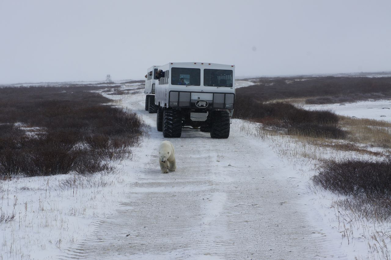
The bear keeps moving and so do we, along a trail that’s headed in roughly the same direction. Kirschhoffer accelerates to a blistering 11 miles per hour—raft speed. I put my hand on the wall for balance as I try to keep binoculars focused on the polar bear, now picking its way around a low pond. The bear switches direction, and then again, as it tests the icy surface. It lies down for several minutes by some willows. Kirschhoffer idles the vehicle to assess the situation. If there was an award for the slowest-motion chase scene, I think, this would win it.
Kirschhoffer parks the buggy along a trail that he thinks lies in the bear’s path. He guesses correctly. The animal ambles our way. When it reaches the buggy, it hoists itself into a standing position and slaps its massive paws onto the vehicle’s aluminum siding. It easily stretches 11 feet tall. The bear sniffs up at the open windows and we all involuntarily take a step back. Then it swings its head over to the red strap anchoring the Trekker to the buggy’s frame and gives it a test chew.


The two polar bear scientists peering out the windows next to me seem equally awed. It turns out even they rarely get this close to the animals—at least while the bears are awake. “Polar bears are extremely intelligent and curious,” says a lanky biologist named Kevin Middel. “They like to know what’s around them and what’s going on. We can see that in trail cameras. They’ll put their nose right at them and sniff.”
In his job for the Ontario Ministry of Natural Resources, Middel studies polar bears in the Southern Hudson Bay population neighboring this one. His work involves tranquilizing female bears (the necks of males are so thick the collars would slide right off) and attaching GPS collars that email their locations every other day. Scientists have a fairly long history of tracking polar bears, Middel says, and that’s brought crucial insights regarding the bears’ behavior.
“They’re such a cryptic species because they go out onto the ice and move huge distances,” he says. “Before this, with hours and hours of observation, we didn’t know where they were. Now we can see where they’re traveling and what boundaries separate them into populations.” By comparing the tracking data to satellite imagery, scientists can also look at how they move with respect to changes in ice conditions.
Once thought to be a single sprawling population that moved throughout the Arctic, polar bears actually make up 19 distinct subpopulations, only five or six of which are well studied. Of those, some are declining, some are stable, and one even appears to be increasing (although it’s still reduced from its historic level). “People want simple answers and it’s often more complex,” says Jay Olson, a graduate student at Brigham Young University who studies bears along the Beaufort and Chukchi Seas in Alaska. “The main thing is that bears need ice.”
The Western Hudson Bay provides the easiest access to bears, and so it’s the best-studied population: Data stretches back nearly 40 years. Here, the number of animals has steadily declined, dropping 22 percent from 1987 to 2004, as the ice breaks up earlier each spring and the ice-free season stretches longer. If spring ice melt continues at its current rate, according to a 2013 paper published in Global Change Biology, polar bears in the Western Hudson Bay will struggle to persist after 2050.
Along the open waters of the Arctic coast, sea ice doesn’t melt completely in the summer, Olson says, but it does pull away from the continental shelf and the bears’ most productive hunting grounds. As a result, all polar bears go through a feast-fast cycle that forces them to live on fat reserves. But over the past several decades, the Arctic has warmed at twice the global rate, and sea ice loss has accelerated. Now, the ice edge moves farther and farther offshore, sometimes several hundred miles. Summer ice extent hit an all-time low in 2012, and though it bounced back slightly last year, it’s continued a 30-year dramatic overall decline.

In the morning, the Google team puts fresh batteries in the Trekker and we head back out in the buggy. As we approach the coast, we hear chatter over the radio. “Looks like Eleanor. Acts like Eleanor,” one driver says. When we pull up to the other buggies we see the bear in question. She’s nose-deep in mounds of kelp along the very edge of the Hudson Bay.
Denver Holt, a wildlife biologist from the Owl Research Institute, extends a fingerless-glove with his Nikon binoculars. “BJ, what’s the score?” he asks. Kirschhoffer lifts the lenses to his eyes. “Belly’s kind of rounded. Big Butt,” he says. “Think it’s a three.” For this time of year, a three out of five isn’t bad on the Polar Bear Condition Score Card, a scale jointly developed by PBI and WWF so that observers can assess a bear’s fitness on the fly. But when researchers like Middel get close enough to handle a sedated bear, they use a more precise body index based on length and girth and analyze fat samples to see what it’s been eating.
In the Hudson Bay population, researchers have documented declining body condition over the past 20 years. With less time on the ice, bears come ashore lighter. And they have fewer, smaller cubs, which have a tougher time surviving until the ice reforms. As a result, the proportion of yearlings has declined; the polar bear population, in the Western Hudson Bay, at least, has grown older. Though less well studied, Southern Hudson Bay is beginning to show the same trends.
Eleanor is really hunkered down. A raven flits from rock to rock, interested in getting in on the meal, but the bear rarely lifts its head. Kelp strikes me as a poor appetizer to seal meat, and Middel confirms that it is. “They’ll do what they can and scavenge,” he says. But there’s no real nutritional value in kelp. Recent studies have shown that landlocked bears will diversify their diets to include snow geese and eggs. “But they can’t fill energy requirements with goose eggs,” Middel says. “They need 43 ring-seal equivalents throughout the winter to survive the summer without food. That’s a lot of eggs.”

I later ask Steve Amstrup, PBI’s chief scientist, about this. He’d been in charge of polar bear research at the US Geological Survey for 30 years and had done extensive fieldwork in Alaska. There, grizzlies roam the tundra, he told me, but at very low populations. “The Arctic coastal landscape can only support small numbers of small bears because it’s very nutrient poor from the standpoint of a bear,” he says. “There are ecological experiments that Mother Nature has already done for us that suggest that there’s a reason polar bars have become such sea ice specialists— because in the Arctic that’s where the environment is that can support a large predator.”
Sea ice supports a lot of other life too, including algae and phytoplankton that form the basis of the Arctic food web. Ringed seals and walruses need the ice to breed and to rear pups. A paper published in Science in August outlined indirect effects of ice loss too, including greater genetic isolation in some species, the spread of pathogens and diseases, and the enhanced warming of adjacent land. But Amstrup coauthored a study, published in Nature in 2010, that he said provides reason to be optimistic: It found no tipping point for sea ice—no point of no return for its recovery. Rather, there’s a linear relationship between global mean temperature and sea ice cover, so controlling the former will save the latter.
“If you build a fence around the sea ice, it’s still gonna melt,” Kirschhoffer says.
That’s why PBI welcomes the Google team and its Trekker. The organization reaches thousands of students a year through its Tundra Connections program, but Google could reach millions with its Street View footage. “With a lot of other species it’s easy to build a fence around them to save them. If you build a fence around the sea ice, it’s still gonna melt. Polar bear habitat’s gone,” Kirschhoffer says. “The trade-off is that you don’t have to build a fence. People can directly impact the polar bears by reducing their carbon footprint.”
Eleanor doesn’t look like she’s going anywhere, so Kirschhoffer starts to convert the buggy into a studio for this afternoon’s class. He sets up a camera, adjusts studio lights, and queues B-roll. Everyone else takes a seat at a folding table behind a replica of a polar bear skull. When the classrooms connect, the biologists describe what they’ve learned about polar bears. Tuxen-Bettman tells them she wants to return in a few years for more Street View imagery, in order to provide a window into climate change. At one point, Kirschhoffer climbs on the roof with the camera to show off the Trekker. Eleanor chews on.
The PBI moderator opens the class up to a Q&A, and the scientists gamely field questions from fourth graders: How deadly is a polar bear? How far can they run? How long do they live? And then, one that catches them off guard: Will current technology stop sea ice from melting too fast and taking too long to refreeze?
Everyone pauses, thoughtful, and then Middel provides an answer. “Technology can record what’s happening, but it’s up to people to make the decisions to cut down on greenhouse gases,” he says. “Technology can help us with those decisions. But it’s not going to fix the problem.”
