In its two years and three months of exploring the Red Planet, NASA’s Perseverance Rover has been one busy moving Martian science lab. It has detected signs of past chemical reactions, begun building a Martian rock depot, and recorded audio of a dust devil for the first time.
[Related: Mars’s barren Jezero crater had a wet and dramatic past.]
Here are a few of the “six-wheeled scientist’s” most recent highlights this month.
New Belva Crater images
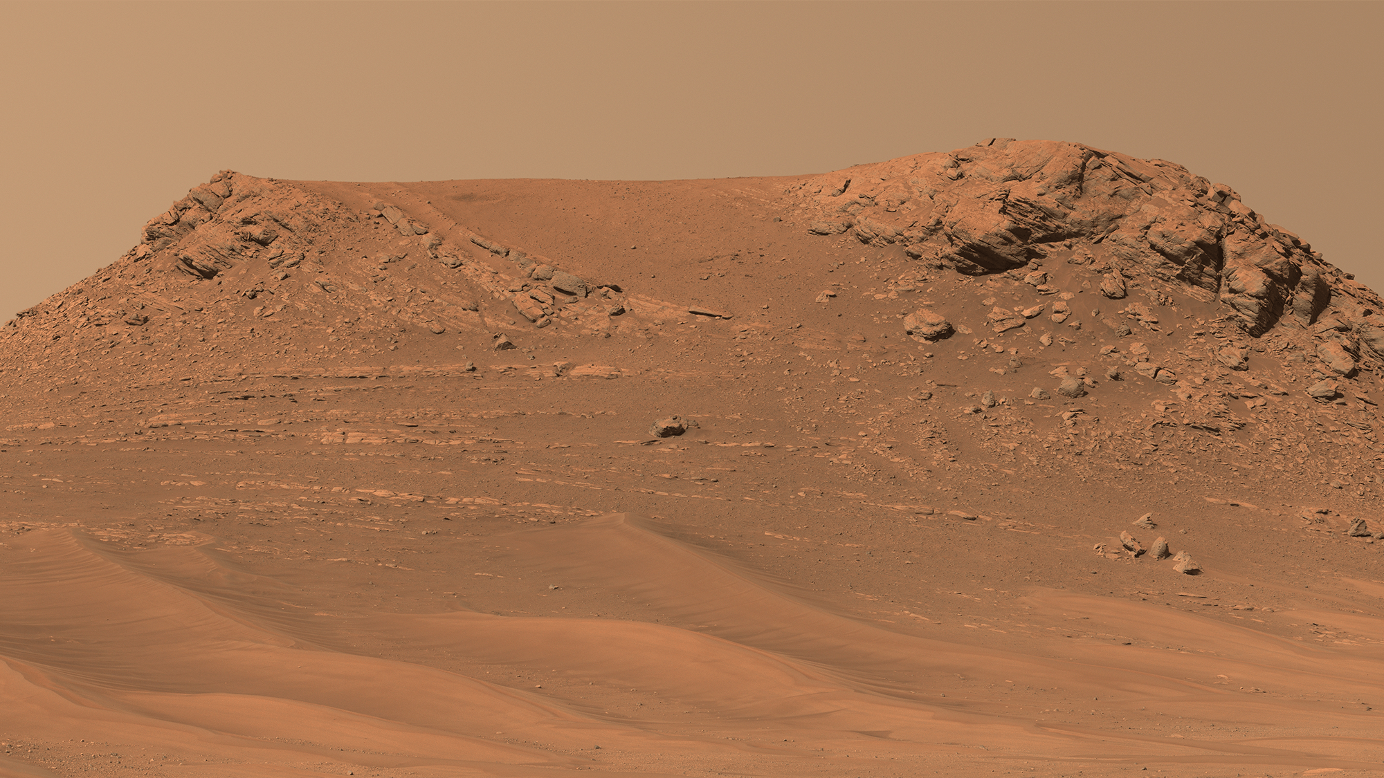
Perseverance’s Mastcam-Z instrument collected 152 images while looking deep into Belva Crater. Belva is a large impact crater that lies within the far larger Jezero Crater, which is where Perseverance landed in 2021. The new images are dramatic to look at, but also provide the science team with new insights into Jezero crater’s interior.
“Mars rover missions usually end up exploring bedrock in small, flat exposures in the immediate workspace of the rover,” deputy project scientist of Perseverance at NASA’s Jet Propulsion Laboratory Katie Stack Morgan said in a statement. “That’s why our science team was so keen to image and study Belva. Impact craters can offer grand views and vertical cuts that provide important clues to the origin of these rocks with a perspective and at a scale that we don’t usually experience.”
According to NASA, it is similar to a geology professor on Earth taking their students to visit highway “roadcuts.” These are places where rock layers and other geological features are visible after construction crews have sliced vertically into the rock. Belva Crater represents a natural Martian roadcut.

The rover took the images on April 22– the mission’s 772nd Martian day, or “sol”. It was parked just west of Belva Crater’s rim on a light-toned rocky outcrop that Perseverance’s science team calls “Echo Creek.” This 0.6-mile-wide crater was created by a meteorite impact eons ago, and shows multiple locations of exposed bedrock and a region where the sedimentary layers angle downward.
These steep “dipping beds” potentially indicate the presence of a large Martian sandbar that was deposited by a river channel flowing into the ancient lake that Jezero Crater once held. The science team believes that the large boulders in the crater’s foreground are either chunks of bedrock that the meteorite impact exposed, or the rocks were potentially carried to the crater by a long gone river system.
NASA says the team will continue to search for answers by comparing the features found in the bedrock near the rover with the larger larger-scale rock layers that are visible in the distant crater walls.
Ancient and wild Martian river
Perseverance’s Mastcam-Z instrument also took some new images that possibly show signs of an ancient Martian river. Some evidence shows that this rocky river was possibly very deep and incredibly fast. This now-dry river was part of a network of waterways that flowed into Jezero Crater.
[Related: Name a better duo than NASA’s hard-working Mars rover and helicopter.]
Better understanding of these watery environments could help scientists find signs of ancient microbial life that may have been preserved in the reddish-hued rocks of Mars.
The rover is exploring the top of an 820 feet tall fan-shaped pile of sedimentary rock, with curving layers that suggest water once flowed there. Scientists want to answer whether the water flowed into relatively shallow streams like one that NASA’s Curiosity rover found evidence of in Gale Crater or if Jezero Crater’s was a more powerful river system.
When stitched together, the images come together like a patchwork quilt with evidence of a more raging river because of the coarse sediment grains and cobbles.

“Those indicate a high-energy river that’s truckin’ and carrying a lot of debris. The more powerful the flow of water, the more easily it’s able to move larger pieces of material,” postdoctoral researcher at NASA’s Jet Propulsion Laboratory Libby Ives, said in a statement.
Ives has a background in studying Earth’s rivers, and spent the last six months analyzing images of Mars’ surface. “It’s been a delight to look at rocks on another planet and see processes that are so familiar,” Ives said.
Both of these discoveries will help Perseverance’s astrobiology mission that includes the search for signs of ancient microbial life. The rover will continue to characterize and study Mars’ geology and past climate, while paving the way for human exploration of the Red Planet, and will also be the first mission to collect and cache Martian rock and regolith.
