Typhoon Mawar pelted Guam with heavy rain and the strength of a Category 4 hurricane over about two days. The storm was upgraded to a ‘Super Typhoon’ when it reached maximum sustained winds of 150 miles per hour as it moved north of the island. President Joe Biden approved an emergency declaration for the US territory of about 150,000 people on Tuesday May 23.
[Related: What hurricane categories mean, and why we use them.]
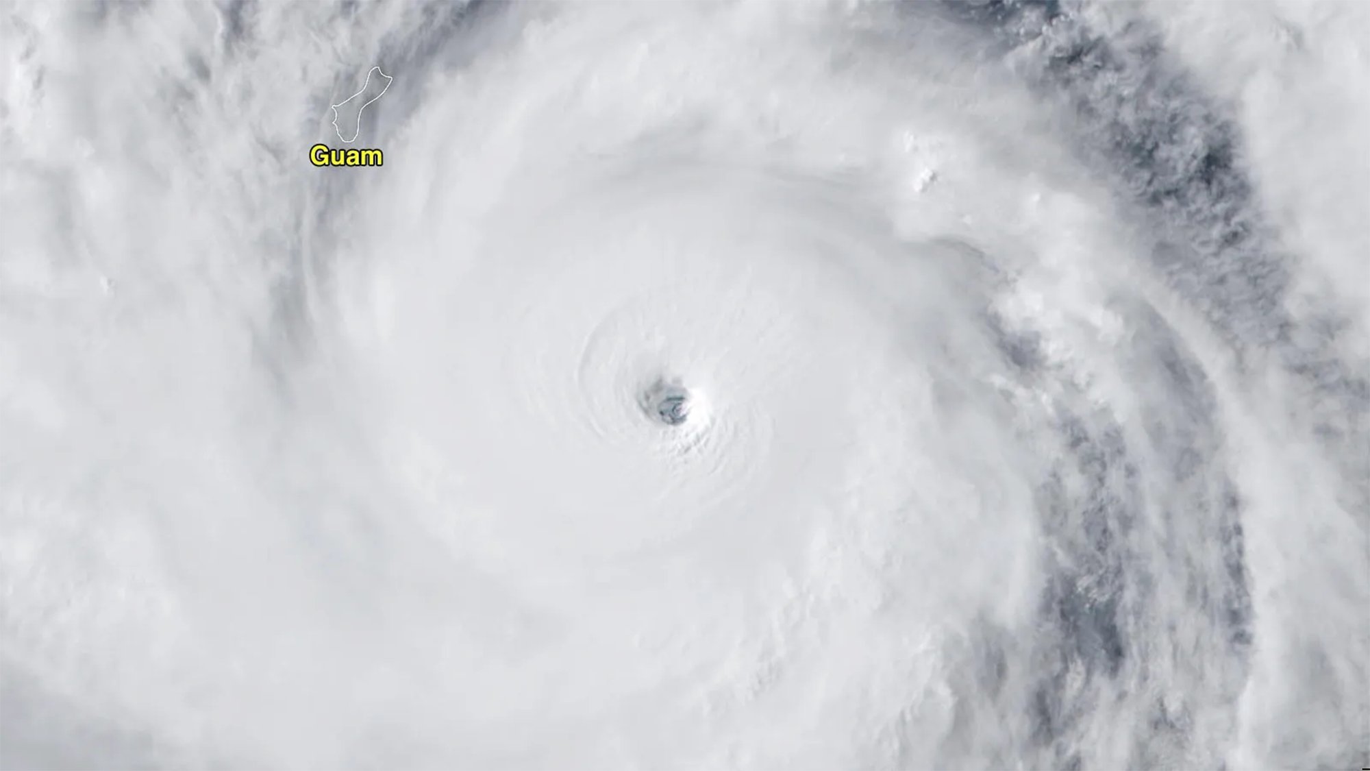
According to the National Weather Service Guam, the storm had Category 4-level winds of about 140 miles per hour just before midnight local time on Wednesday May 24 as it passed over Guam. Guam International Airport recorded sustained winds of 71 mph and a gust of 105 mph. The storm’s eye passed just north of the island, but the powerful eyewall hit the whole island.
Initial estimates say that close to a foot of rain fell and approached two feet in some parts of the territory. Guam is about the size of the city of Chicago and sits about 1,500 miles east of the Philippines.
Typhoons are the same type of warm-core tropical storm as hurricanes, except that they form west of the Northwest Pacific Ocean. Mawar was one of the strongest typhoons to hit Guam in decades. In 2002, Super Typhoon Pongsona struck the island with the force of a Category 4 hurricane and caused over $700 million in damage.
In an address on Facebook, Guam Governor Lou Leon Guerrero urged residents to stay home for their safety, as the island was still seeing 40 to 50 mph winds on Thursday morning. The governor reported that the strongest winds from the storm were felt throughout the island, but particularly in the north.
The Guam Power Authority reported that the island’s energy grid was providing power to only about 1,000 of its roughly 52,000 customers. As of Thursday morning, the government had not reported any deaths due to the storm.
According to The New York Times, strong building codes minimized damages and deaths from major storms in Guam. In most cases, “we just barbecue, chill, adapt” when a tropical cyclone blows through, says Wayne Chargualaf, who works at the local government’s housing authorities. However, since it has been over 20 years since Super Typhoon Pongsona, he told The Times that “we have an entire generation that has never experienced this. So a little bit of doubt started to creep into my mind. Are we really ready for this?”
[Related: Typhoon Merbok breaks records as it lashes the Alaskan coast.]
Human-caused climate change is contributing to an increasing number of intense tropical storm systems like Mawar. Tropical systems are generating more rainfall and bigger storm surges and are also more likely to intensify faster. Mawar rapidly intensified from Monday into Tuesday, with the storm’s top wind speeds increasing by 50 mph in only 18 hours.
Mawar will continue to track west-northwest away from Guam and towards the northern Philippines and Taiwan. It strengthened to the equivalent of a Category 5 hurricane with winds of 165 mph and gusts up to 200 mph, but slow weakening is likely and it is not expected to threaten land in the next several days.
The Atlantic Hurricane Season begins on June 1 and runs until November 30. The National Hurricane Center is already watching a system off the coast of Florida. An early forecast from Colorado State University released in April calls for slightly below-average hurricane activity, partially due to the current neutral conditions before El Niño likely begins in the Pacific Ocean.
