While much of Puerto Rico was in the dark due to Hurricane Fiona and surges of water from Typhoon Merbok inundated buildings in western Alaska, Japan faced its own major storm.
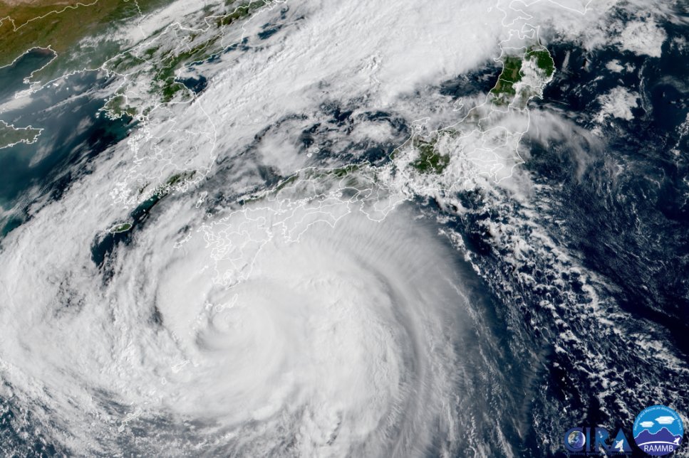
Typhoon Nanmadol made landfall near Kagoshima city on Sunday evening with winds of 110 miles per hour, the equivalent of a strong Category 2 hurricane. According to The Japan Meteorological Agency (JMA), its central pressure was 935 millibars at landfall, making it the fourth-strongest typhoon on record to make landfall in Japan since the agency began collecting the data in 1951.
The storm roared onto the main island of Honshu on Monday morning. Nanmadol began to weaken as it moved over land yesterday, but still brought heavy rains. By Monday evening, parts of Kyushu, Shikoku island, and the region of Chugoku experienced rainfall over seven inches in 24 hours. Shikoku’s Yanase saw more than 15 inches of rain.
According to Yale Climate Connections, the southern main island of Kyushu saw the heaviest rainfall, where observations showed five separate weather stations picked up 19.69 inches of rain in 24 hours on Sunday. Millions of people in southern and western Japan were asked to evacuate their homes before the typhoon hit and over 300,000 households across southwestern Japan were left without power.
Bullet trains and airlines suspended service, while store chains and delivery services temporarily shuttered in southwestern Japan. Around 130,000 homes in the region remain without power as of this morning.
[Related: This typhoon-resistant facility in Guam will power the tubes that give us the internet.]
According to reporting from Reuters, at least two people have died in the storm and dozens of other injuries have been reported. Close to 20,000 people rode out the storm on Sunday night in shelters in Kyushu’s Kagoshima and Miyazaki prefectures, where the JMA has issued a rare “special warning.” This is an alert that is issued only when it forecasts conditions seen once in several decades.
Today, Tokyo is forecast to experience up to 6 inches of rain, possibly at a rate of 2 inches per hour.
Prime Minister Fumio Kishida postponed leaving for the United Nations General Assembly in New York this week to assess the damage. “I postponed my scheduled departure from today to take stock of the damage caused by the typhoon and to take all possible measures for recovery,” Kishida told reporters on Monday evening. This morning, Kishida left for New York.
[Related: Proof Of Japan’s Kamikaze Typhoons Found In Ancient Rocks.]
The latest forecast has Nanmadol just offshore the Tottori prefecture in the Sea of Japan. Its sustained winds have fallen to 63 MPH and the storm is not expected to strengthen. It is expected to make another landfall as a weaker storm in mainland Japan, but heavy rainfall is still expected, before the storm turns out to sea tomorrow.

While typhoons can form all year in Japan, typhoon season typically peaks from July to October. Nanmadol is the 14th typhoon Japan has experienced in 2022 and follows record setting heatwaves in June. The heat caused millions of residents of Tokyo to lose power and several cases of heatstroke.
