

In the immediate aftermath of a natural disaster, emergency responders need clear images of the affected area as quickly as possible. When massive flooding hit Colorado last week, a local company called CLMax Engineering volunteered their drone to take aerial photos of submerged communities. The Falcon UAV began to create a map of the flooded areas, until the Federal Emergency Management Agency took over and told the company to stop.
The camera-carrying Falcon UAV weighs 9.5 pounds, can fly for an hour, and has a wingspan of 8 feet. It’s launched into the air by hand, like a giant paper airplane. With FAA approval, police in Mesa County, Colo., tested the drone for search and rescue missions, wildland fire monitoring, and broad area suspect searches, and the Falcon UAV is now cleared to fly with police in the county during daytime hours.
CLMax Engineering launched the drone into the storm on September 11 and partnered with Colorado-based DroneMapper to build maps out of the images collected during just a few flights.
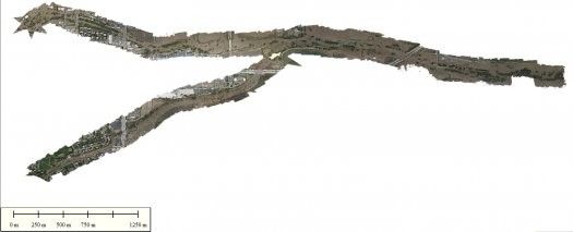
According to a post published Saturday on the Falcon UAV blog, for three days after the storm CLMax Engineering volunteered their services to the Boulder County Emergency Operations Center. Other aircraft were grounded due to weather. The Falcon UAV created this map of the flooded area:
From the same photos, here is an animation of the flooding overlaid on Google Maps:

Last Saturday, President Obama declared the flooding in Boulder County a major disaster, and FEMA took over emergency operations. According to the Falcon UAV blog, the company’s request to continue flying drones as part of rescue operations was denied. “More specifically we were told by FEMA that anyone flying drones would be arrested,” says the blog post.
At the same time that FEMA shut down drone flights, other aircraft were allowed back into the skies over Boulder. That’s actually… entirely reasonable. At present, drones are only cleared by the FAA in limited cases to fly in the U.S. The FAA plans to approve drones for flight in regular airspace starting in 2015, but right now the complicated nature of incorporating manned and unmanned aircraft into the same sky hasn’t really been figured out.
While drones can be very useful in emergencies, testing them in the middle of a disaster response without approval is a big unknown, and it’s probably wise for FEMA to want the skies as normal as possible.
Drones like the Falcon UAV have plenty to offer disaster relief, and it’s entirely possible that drone flights could co-exist with the operations of normal aircraft. Even more promising than concurrent manned and unmanned flights is the Falcon’s ability to fly in the storm and create maps when no other aircraft could.
FEMA was reached for comment but didn’t have a response at time of publication.
Update 5:10pm Tuesday: A FEMA official told us the decision to ground the drone was made locally by the county to prioritize emergency response efforts. According to 9News.com, the Boulder County emergency manager says “he’s shocked the drone operator – Falcon UAV – is making that claim” and “local emergency managers grounded the drone out of concern that it could collide with helicopters being used to evacuate residents.”
Popular Science has reached out to local authorities in Boulder and is currently waiting to hear back.
