The world’s biggest tornado hunt is stuck. I’m at an improvised command center in the conference room of the Holiday Inn Express in Perry, Oklahoma, and 35 scientists are trying to decide where, on this cloudy May morning, to deploy the 50 equipment-laden trucks parked outside. The first major storm system of the expedition is forming southwest of us, in Texas, and it’s likely to lead to supercells, massive rotating thunderstorms that may in turn spin off one or more twisters. Very promising. But Lou Wicker, a team leader from the National Severe Storms Laboratory, sees a problem. He looks up from a radar screen. “Fifty miles per hour,” he says. Too fast.
The popular image of the tornado hunt is of a few trucks speeding across the plains, dirt flying, in pursuit of monster funnels, but Wicker’s project, the second Verification of the Origin of Rotation in Tornadoes Experiment, known as VORTEX2, calls for a very different kind of chase. The goal of the two-year, $12-million government field experiment is not simply to get close to a tornado, but to surround it and capture enough data to accurately re-create it in a computer model. With an armada of trucks and vans, 140 crew members and several tons of gear—from 40-foot-tall portable radio masts to weather balloons to an unmanned aerial vehicle—success requires far more than just daredevil driving. It requires a great deal of methodical planning, which in turn requires a great deal of advance information. “It’s tough to do even on days with slow storms,” says Josh Wurman, a team leader from the Center for Severe Weather Research. “It’s bordering on impossible on a day like today.”

Now, with a mere five weeks left before the storm-chasing season ends, the VORTEX2 team is anxious to head out. Only about 1,000 tornadoes are reported in the U.S. every year, and that rarity is the central challenge of storm chasing. Tornadoes touch down unexpectedly, do terrible damage, and disappear. Researchers have sparse data to rely on while trying to determine where and when the next one will strike. This makes chasing them hard, and offering reliable warnings even harder. In fact, 70 percent of tornado warnings are false alarms. As a result, people tend to take the next warning far less seriously. “We detect rotation, and we issue a warning because we’re scared not to,” says Don Burgess, a team leader who works part-time as a research meteorologist at the University
of Oklahoma.
In trying to improve the situation, the VORTEX2 team is faced with a chicken-and-egg quandary: Intercepting more tornadoes requires better prediction models, but better prediction models require intercepting more tornadoes. When VORTEX2 completed last year’s hunt, the team had managed to surround only one twister, in LaGrange, Wyoming. It was a major catch but, as Wurman says, “one tornado is not enough.”
Wicker puts his finger on a map. “Here,” he says, pointing to the predicted center of storm activity, a spot about 40 miles to the east. Because most tornadoes lumber along at about 15 mph, the typical chase strategy is to drive alongside them and deploy sensors and instruments to collect data on the fly. But a fast-moving storm calls for much different maneuvering. The team members must spread out quickly, Wicker explains, get ahead of the storm, and set up a perimeter of instruments capable of measuring whatever happens within an area of about 1,000 square miles and then wait for a tornado to spin through it. Still, he cautions, even with several hours’ preparation and a large footprint, surrounding a moving disaster area will not be easy. “It’s difficult to chase 50-mile-per-hour storms when you’re by yourself, let alone with 50 vehicles,” he says. “With this many people, it’s like trying to run errands with a car full of kids who all have to take bathroom breaks at different times.”
At the moment, better drivers would help too. A technician interrupts the meeting to announce that there’s been an accident, and Wurman heads to the parking lot to assess the damage. In all of the preparatory rush, one of the fleet’s 10 Doppler-radar trucks has backed into another, damaging the connection between the radars and the internal computers, an essential part of both trucks. Repairs could take hours.
Wurman looks at the trucks and shakes his head. “We’ve duct-taped a lot of broken parts on my trucks in the past 10 years,” he says, “but this is just about the worst possible scenario.”

WHY CHASE?
The VORTEX project is the world’s most ambitious effort to understand tornadoes. When the National Severe Storms Laboratory conducted the original VORTEX field experiments in 1994 and 1995, Wicker and Wurman, along with meteorologists Harold Brooks and Don Burgess, became the first scientists to surround a tornado with radar trucks. With their “Doppler on wheels,” they were able to capture rare ground-level views of tornadoes and document for the first time a twister’s entire life cycle.
But fundamental questions remain. For example, why do funnels form in the first place, and what makes some tornadoes strong while others are barely a wisp? What fuels them? By understanding the basic mechanics of twisters, Wicker and his team are looking to improve tornado-warning times from 13 minutes to 50 and, ultimately, mitigate property damage and save lives.

VORTEX2 includes more researchers, new mobile weather sensors and improved forecasting techniques. The revamped effort is already paying off. Last year’s catch in LaGrange is the most extensively documented tornado in history. This month, scientists will meet in Colorado to divide the data for analysis. From there, one of the big goals is to develop dozens of computer models that will run simultaneously, analyzing real-time storm data on a minute-by-minute basis, each of them calculating different inputs: bigger raindrops, heavier winds, greater humidity. The combined results would generate far more specific guesses about future conditions, so that weather forecasters confronted by, say, a supercell formation 10 miles north of Chicago could avoid issuing a blanket warning for the entire metropolitan area and instead announce more-accurate probabilities for a far smaller area.
Today’s severe-weather warnings draw heavily on data gathered by NEXRAD, the network of 159 stationary Doppler radars operated by the National Weather Service. But stationary radar is often too far away from thunderstorms. Its signals spread out like a flashlight beam, becoming more diffuse the farther they go. Radar also travels along in a single plane, so it misses the lower regions of the atmosphere as the Earth curves away beneath it.

The VORTEX2 solution is to get closer and record the supercell from every conceivable angle. A radio-controlled unmanned plane canvasses the clouds, collecting data on the streams of air that feed the supercell. Team members drive vehicles with roof-mounted instruments underneath the storm to sample conditions like temperature and humidity. Video cameras mounted on tornado-resistant platforms photograph activity inside the funnel.
The robust storm forecasts that should result from this kind of surveillance will deliver better storm warnings and also improve airport flight patterns, forest-fire indexes and city planning. They could even lower electricity bills. Utility companies rely on storm warnings to determine how much electricity they need to generate, and if the forecasts are wrong, the companies must buy energy at the last minute at a premium, passing the cost on to consumers. “I wouldn’t be surprised,” Brooks says, “if we look back 30 years from now and the models turn out to be, from a societal standpoint, more important than anything to do with tornado warnings.”
This year, the National Oceanic and Atmospheric Administration will begin upgrading NEXRAD with new dual-polarization radars, already a standard part of VORTEX2’s armament, which send out horizontal and vertical microwaves to read the sky more accurately and distinguish among snow, ice and raindrops. A project is also in the works to outfit cellphone towers and rooftops across the country with thousands of Doppler units. For now, though, the best way to find tornadoes is still to get in a truck and go look for them. “I don’t think we’ll ever be doing this work from armchairs,” Wicker says.

SETTING THE TRAP
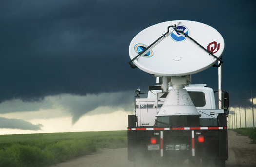
Wicker and other leaders have made their best guess: The storm will strike northeast of Oklahoma City by 4 p.m., leaving the crew just a few hours to perfectly position 50 vehicles across a grid the size of Rhode Island. But at 10:30 a.m., we’re still organizing in the hotel parking lot. Finally, at 11, Wicker rushes me and one of his graduate students into a minivan, and we drive off, later followed by two of the 10 radar trucks that make up the mobile Doppler system. We are headed for the northern border of the grid, about 25 miles distant, where our radar dishes will trace the storm from afar.
The technicians, meanwhile, have managed to repair the damaged radar trucks, which are now headed 40 miles southeast of us toward Stroud, closer to the center of the grid. Individual Doppler-radar data sets are useful to track a storm’s development, but coordinated data from multiple units is far more revealing, just as slightly different visual images combined, as in a three-dimensional view, can provide more information about depth.

We arrive in the general vicinity of Coyle in 30 minutes, but we can’t simply park and wait. The radar requires an open line of sight, so we spend the next two hours looking for a perch unobstructed by houses, trees or hills. We eventually find a flat, open stretch of land and pull over. The overcast sky makes me nervous. We are at the edge of the grid, as far as we can be from the predicted epicenter of the storm, but no position is safe. In the U.S., a tornado generally moves southwest to northeast, swept along by the combined action of the jet stream and warm currents rising from the Gulf of Mexico, but it can change course suddenly.
I consider this fact as we exit the van and pay special attention to how the rising wind is bending the tall grass flat. A red pickup truck slows to a halt alongside us. “We gonna get hit?” the driver asks. Wicker points skyward at the available evidence: an indentation at the rear of a patch of grayish, puffy clouds. “That’s where the warm downdraft’s wrapping around the back of the storm,” he says. “This thing will probably produce a tornado in another hour.” The driver nods. “I appreciate it,” he says, and drives off.
Lightning flashes, and Wicker directs me back into the minivan. Heavy drops of rain start to smack against the windows. He takes another chug of Dr Pepper, his third can of the day, and we wait, scanning radar data and instant messages from the rest of the team. Nothing. An hour later, the storm changes course and starts moving south toward Oklahoma City, and I begin to see how little anyone really knows about tornadoes, and how dangerous that is. Wicker receives an instant message from the National Weather Center, 100 miles away in Norman. A tornado has been sighted, but not near Oklahoma City, as predicted. In fact, it has touched down in Wicker’s hometown, Norman, not 200 yards from the National Weather Center. Then come the news reports: Hailstones pounding houses near Moore. Cars flipped on Interstate 40. A gas station obliterated in Shawnee. There are at least 58 twisters in Oklahoma, and by day’s end, they will have killed three people. Wurman’s cellphone rings. It’s his father, calling to check that he’s safe. “Too safe,” Wurman answers.

MODELING THE STORM
Most of the tornadoes got away, Wicker says, three months later at his desk in Norman, and that near miss had cast a pall over the project for a week. “After that, we made a deliberate decision to bust our butts.” That meant leaving earlier in the morning and taking fewer breaks during the day. With some cooperation from the weather, VORTEX2 went on to intercept 20 tornadoes by the time the expedition ended in June. “A lot of serendipitous stuff came into play,” Wicker says.
Over the course of the two-year project, the team collected more than 50 terabytes’ worth of data, and they now stand to produce the most detailed anatomy of tornadoes ever compiled. “It’s an embarrassment of riches,” Wurman says. “We’ll have data to chew on for years.”
Researchers are paying particular attention to wind data inside and around the tornado storm that could reveal how twisters peel roofs off homes and flatten towns, in an effort to improve building codes. “An F-5 tornado will blow anything down,” Wicker says. “But for smaller events, you can make your house survive quite well. It just costs more money.”
As I pass the post-tornado wreckage from May 10 on the way to the Oklahoma City airport, such an investment seems wise. Enormous uprooted trees line the highway. The storm has sheared off the roof and blown down the walls of a Love’s gas station, leaving only its twisted metal support beams. The cab driver tells me his sister hid from a tornado in the gas station’s walk-in freezer. She called him, terrified, but by the time he could reach her, the storm had passed. “It was over so quick,” he says, snapping his fingers.

THE HOMEMADE TORNADO TANK
A tornado can pack as much kinetic energy as a bomb, so veteran storm chaser Reed Timmer and his team, who star in the Discovery Channel series Storm Chasers, built themselves a four-ton tank dubbed the Dominator to stay safe on the job.
The team started by gutting a 2007 Chevy Tahoe and then wrapped it in a 16-gauge-steel shell. To fortify the sheet metal, they sprayed it with a quarter-inch-thick, bulletproof combination of Kevlar and polyurethane called Rhino Lining. “You can hit it with a sledgehammer, and it’ll bounce right back,” Timmer says. They also installed bulletproof windows made of half-inch-thick sheets of polycarbonate, plastic that’s strong enough to withstand hailstones the size of watermelons and debris flying at speeds of up to 150 miles an hour.
When heading into storms, the crew straps in with five-point safety harnesses fit for Nascar, although Timmer admits that during a chase, he’s often too busy launching weather probes from miniature potato guns to buckle up. (He can track the probes on his laptop as they measure GPS position, temperature, pressure and moisture five times a second.) If wind speeds reach 100 mph and threaten to toss the truck, the crew flips a James Bond-style switch to activate battery-powered hydraulics that lower Dominator to the ground. A rubber sheath around the truck’s bottom flares out and creates a vacuum seal to keep out debris and help anchor the vehicle. And, as tanks go, the Dominator sips fuel, getting 14 miles to the gallon.