
Hurricane Irma continues its steady march toward the Contiguous United States this evening as a dangerous category five hurricane, threatening to slam into southern Florida as the strongest storm seen there in a generation. Just about every major city in Florida stands to see dangerous conditions, and the threat doesn’t stop there. Hurricane Irma will likely continue on to the southeastern United States after hitting the sunshine state, potentially bringing strong winds and heavy rain to Georgia and the Carolinas early next week.
What Irma is doing now
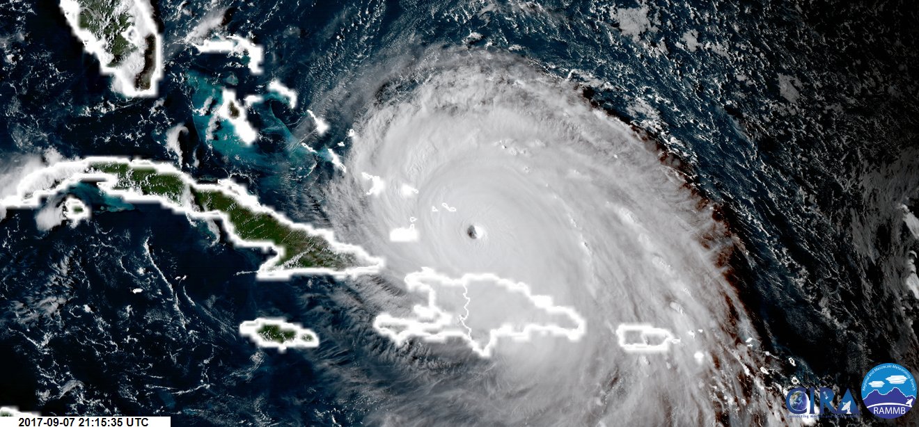
The storm will move over the Turks and Caicos Islands on Thursday night before reaching The Bahamas on Friday. A hurricane watch is currently in effect for all of southern Florida—including inland counties—which means that hurricane conditions are possible within the next 72 hours. The watches will be upgraded to warnings (which mean conditions are imminent) during the day on Friday, with additional watches and warnings going into effect for locations up the coast as we get closer to landfall.
Hurricane Irma’s intensity and longevity is a remarkable feat for any tropical cyclone, let alone one in the Atlantic Ocean—where the environment isn’t typically supportive of such a monstrous storm. The National Hurricane Center’s update at 5:00 PM EDT on September 7 found that Irma had maximum sustained winds of 175 MPH, which makes the storm a powerful category five on the Saffir-Simpson Hurricane Wind Scale. Irma has maintained category five intensity since 7:45 AM EDT on September 5, and it’s expected to remain there until Friday afternoon, likely breaking the record for longest-lived category five hurricane ever observed in the Atlantic and cementing it as one of the most persistent ever recorded on Earth.
What happens next
The hurricane’s future is a little more uncertain once it moves past The Bahamas. Forecasters are increasingly confident that the hurricane will have significant impacts on the U.S. mainland, but Hurricane Irma’s exact track will determine where the worst destruction will occur, and just how much damage residents will have to deal with once the skies clear out.
The latest forecast from the National Hurricane Center puts the worst part of the hurricane into southern Florida during the day on Sunday. If the forecast were to hold true, this would expose Miami and its suburbs to the intense winds and storm surge of a category four hurricane. The storm would traverse the entire length of the state of Florida before entering Georgia, and eventually the Carolinas, as a weakening but potent system capable of producing widespread flooding and wind damage.
Unfortunately, a track straight up the Florida peninsula would be worse than a head-on strike. When a storm hits the shoreline at a perpendicular angle, the most intense winds and storm surge are focused on one particular location. However, in Irma’s case, the strongest winds will scrape across hundreds of miles of land, exposing tens of millions of people to intense winds and extreme flooding.
A significant storm surge—sea water that’s pushed inland by strong, persistent winds—is possible along the coast during the height of the storm. The National Hurricane Center expects a storm surge of five to ten feet along the Florida coast in the hurricane watch, but exact surge levels there and farther north will be refined as the track and intensity forecasts are adjusted over the next few days.

Flooding from heavy rain is a significant concern. Hurricane Harvey (and many storms before it) proved that it’s not only the wind and sea water that poses a grave threat when a tropical cyclone makes landfall. The latest forecasts indicate that five to ten inches of rain are possible along Irma’s path, with higher amounts likely in some areas. This much rain in a short period of time will likely lead to flash flooding.
Uncertainty ahead
It will only take a small change in Irma’s track to dramatically alter which areas see the worst conditions. We saw this when Hurricane Matthew came perilously close to making landfall on Florida’s east coast last year, but the most intense winds of the eyewall stayed just one or two dozen miles offshore. If Irma wobbles to the west or the east by just a few dozen miles, it could mean the difference between a historic disaster and an incredibly close call. These small meanders will also dictate how intense the storm is once it reaches Georgia and South Carolina. If Irma stays east and misses Florida, it will lead to a much more dire situation for these areas.
Adding insult to injury is the fact that Irma is a large hurricane, more than twice the size of both Hurricane Charley, which hit Florida’s west coast in 2004, and Hurricane Andrew, which slammed the Miami area in 1992. Hurricane Irma’s tropical storm force winds (greater than 39 MPH) extend nearly 200 miles away from the center of the storm, while the extent of hurricane force winds stretch 75 miles from the eye. Even communities far away from the center of the storm will experience a period of dangerous weather conditions as it makes its way inland.
The National Hurricane Center has ordered at least four reconnaissance flights into Hurricane Irma during the day on Friday, with two additional missions for aircraft to fly at an altitude of 45,000 feet to sample the atmosphere around the hurricane. Additionally, we’ll get more data from 51 observing stations across the United States as they continue launching weather balloons four times a day—up from the typical twice-daily launches—to help sample the atmosphere. All of this extra data will be loaded into the weather models to help us get a better idea of exactly where Hurricane Irma will travel over the next five days.