Bad weather is bad business. That’s especially true if you’re an airline or commercial pilot, though it impacts everyone. Weather-related delays and cancellation tax the economy for billion of dollars in lost productivity each year, much of which is borne by the airlines themselves. And of course there’s the occasional human cost of weather as well. Every so often, a rapidly forming weather event or a bad decision by a pilot costs lives. People die flying through severe weather (you mostly hear about this when it’s a larger passenger jet, but smaller planes crash more often than you probably realize). That’s why technology giant Honeywell sends engineers out flying in a 60-year-old twin-propellor aircraft looking for storms. And that’s why today I’m going with them.
Honeywell is a technology solutions company that you know but may not realize you know (they build everything from the fire safety system in your office building to better body armor materials for police officers to longer-lasting brake pads for our cars), and today it is showing off a solution to a shared problem that we perhaps don’t realize we have: When we board a flight bound for anywhere, the pilot or pilots in the front seat have a really poor view of the weather ahead. In a sense, they are flying (nearly) blind into an atmosphere that can quickly turn hostile.
Honeywell’s newest weather radar system for aircraft removes that uncertainty by painting a detailed picture of the weather ahead in three dimensions, and even predicts–with 90 percent accuracy–where within a storm system the most inclement weather is hiding. That accuracy allows pilots to deviate from their flight paths only when necessary, and when they do they can plot an optimal course through or around foul weather–saving fuel, time, and money in both instances. Better information in the cockpit should lead to fewer delays, more direct journeys, and huge cost and fuel savings (not to mention a smoother travel experience). And in that rare but terrifying case, such a system could save lives.
THE OLD WAY
Our airliners are largely legacy machines–old aircraft with old systems onboard. Weather radar is no exception. Mounted in the nose of the plane, conventional radar antennas send a flat, horizontal beam out into the space in front of an aircraft and sense whatever signal bounces back off of objects–like clouds–in the sky. On their displays, pilots see just a thin horizontal slice of the sky in front of them, represented as the bird’s-eye view of cloud coverage like the one we see on the morning meteorology broadcast. Pilots can tilt the radar beam up or down to sample a different slice of the sky, but at any given moment they can only see what the radar is pointed at.
Given that storm systems are complex and three-dimensional, 2-D horizontal radar provides a weak profile of a storm ahead. A pilot wishing to locate the top of an incoming thunderhead, for instance, must tilt the radar up and down looking for the elevation where the storm no longer appears on the display, then calculate its distance from the plane against the angle of the radar tilt while accounting for the fact that the plane is speeding through the air. If the math is correct–and there’s plenty of room for human error here; the pilot is doing this while also operating the aircraft–cockpit personnel get a decent estimate of how high they must climb to miss the storm.
That’s if the radar sees the storm at all. Radar systems–particularly those working at shorter wavelengths–are susceptible to what’s known as attenuation. Simply put, this is when a radar beam is scattered or absorbed by the storm and a very weak echo is returned. It tends to happen at longer ranges and when the beams have to pass through many hydrometeors (water droplets or ice crystals in the atmosphere). So the bigger and more moisture laden a storm is, the more likely it is to attenuate a radar beam. And an attenuated radar beam, on a radar screen, looks like nothing. It’s black, like empty space. The biggest storms can look like no storm at all.
Really nasty weather is tracked by more sophisticated ground radar and satellite as well, and air traffic controllers do offer better information to pilots when they have the time. But the job of keeping tabs on the weather and using that information to adjust flight paths optimally falls to the pilots alone. And you might be surprised to learn how scarce that information can be. The pilot doesn’t know a whole lot, and what he or she does know is subject to both technological and human error.
SEEING 320 MILES INTO THE FUTURE
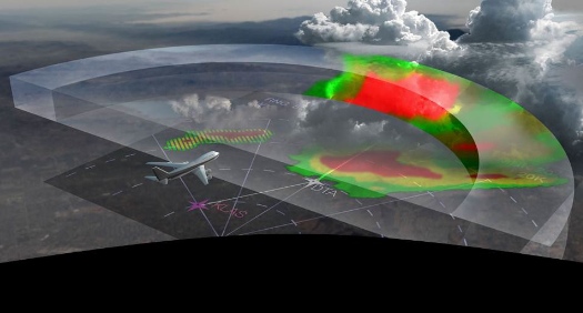
“You can’t see this on conventional radar,” Dr. Ratan Khatwa says, both his face and the radar screen mounted in the plane’s passenger cabin lighting up almost simultaneously. Khatwa is a senior chief engineer at Honeywell Aerospace and today’s emcee as we lift off from Dulles International Airport and cruise across Virginia at roughly 20,000 feet in Honeywell’s Convair 580 test aircraft, a twin-engine turboprop that turned 60 years old this year (it used to fly passenger routes for United Airlines). What he means is you couldn’t see what we’re seeing on the radar screen in front of us with a standard 2-D radar unless you were both a trained pilot and a trained meteorologist and also very lucky. Even then, you couldn’t see it like this. You’d have to infer it from the data and imagine what it really looks like.
Honeywell calls its technology IntuVue, and it’s clear why: lacking any real background in aviation or meteorology, I can read this screen intuitively. That’s by design. Khatwa tells us the training manual is only ten pages, and pilots who aren’t enthusiastic about even a ten-page read can take a quick online training course. That’s because by adding a layer of automated computing to a new kind of radar antenna, IntuVue ensures that the pilot has to do a minimal amount of work to receive excellent radar interpretation. It’s taken the beam tilting, the arithmetic, and the guesswork out of the enterprise and given pilots a rather complete view of the sky ahead.

IntuVue’s big innovation is that it takes something analogous to a 3-D snapshot of the sky for the entire 180 degrees forward of the aircraft. It doesn’t simply pulse a horizontal radar beam out to capture a single flat slice of atmosphere, but rapidly pans and tilts to capture radar data from the ground up to 60,000 feet (it uses topographic map data to remove signal noise generated by radar bouncing off the ground), then quickly computes that data into a single picture of that entire space in front of the aircraft out to 320 nautical miles (it refreshes this image every couple of seconds). It captures the density of the clouds and the movement of reflectors (moisture) within them, extrapolating the intensity of the weather within in the standard green-to-red scale familiar to the local news station’s Doppler map. Churning clouds indicative of turbulence appear as bright magenta blobs. IntuVue even has a sense for when it’s being tricked by an attenuated signal, designating with cross-hatched purple lines the areas where it is not registering anything but it thinks storm activity may be hiding.
In automatic mode, the system visually shows the pilot only the weather relevant to his or her flight path–that is, the weather within 4,000 feet above or below the aircraft. But because the entire navigable sky has been imaged, a pilot considering an altitude or course change can easily explore the weather at other altitudes or along other headings. Pilots can even get something 2-D radar simply can’t provide in any kind of timely manner: a vertical profile display, showing what a storm cell looks like from top to bottom as viewed from the side (rather than the usual bird’s-eye view) so they can determine if the storm is more intense at higher or lower altitudes.
But the aspect of IntuVue that really pulls weather radar into the 21st century–the technology that is still largely stuck in the 1960s and 1970s, at least in commercial aviation–is its power of prediction. Khatwa’s radar screen hasn’t just lit up with varying green, yellow, and red blobs of atmospheric activity as we make our way toward a line of storms we’re targeting in the western Carolinas. It’s also lighting up with symbols within those storm clusters indicating where the system thinks the is lightning and hail.

It’s here the technology goes beyond both radar as we know it and pilot intuition into something even the best human mind working a 2-D radar could only make a semi-educated guess at. The radar data is all raw, gathered by the antenna in the nose of the airplane, Khatwa says. But augmented with some computing power, the system can also draw inferences beyond what the raw data can see. By rapidly running the radar data through some probabilistic algorithms, it can infer where exactly within a storm cell there is likely to be the kind of activity that is dangerous to aircraft (for now that’s limited to lightning and hail, though in the future the algorithms are bound to get better and broader). Honeywell has checked IntuVue’s predictions against other meteorological data from the ground and claims that nine times out of ten its lighting and hail predictions are correct.
From where we sit in the cabin of the aircraft, we can see not only what weather is on the way but where and what kind of weather it’s going to be, even hundreds of miles away. Right now, our screen is showing a massive storm cell about 80 nautical miles out dotted with jagged yellow lines, the universal symbol for electricity. It’s the thunderstorm we’ve been looking for and we’re heading straight for it.
STORM CHASING
Out in front of our storm there is the usual sprawl of overcast clouds, and IntuVue is showing patches of turbulence throughout. The pilot advises us to buckle back into our seats, and things do begin getting choppy, shaking the Convair and putting us through a series of those little lurches you experience every so often on a passenger jet, the kind that put butterflies in your stomach and that are more pronounced in our smaller twin-prop. Outside the aircraft, we are enveloped by clouds. “It’s like a blizzard out there,” a disembodied voice says over the headset, though I can’t tell who said it. As we lurch again the pilot comes on: “We probably shouldn’t go closer than ten or 20 miles.” No one argues.

What does bad weather look like? On the screen, it looks big–green around the fringes then yellow as you move inward, with patches of red indicating the strongest parts of the storm–and is dotted with lightning bolt symbols as well as a few lollipop-looking symbols that indicate a likelihood of hail. It is also layered with magenta–lots and lots of magenta–indicating turbulence, and along with lighting and hail that’s what pilots want to stay away from.
Our storm actually shows fairly light lightning and hail presence, but lots of strong turbulence. And it looks massive. As we get closer to the edge of the major cell things actually smooth out and we climb out of the layer of clouds surrounding it and into the sunshine. Grabbing my camera I move up to the cockpit hoping to snap some images of the monstrous thunderhead in front of us, but I’ve only clicked the shutter a few times before the pilot tells me we have to make our turn. The thunderhead we’ve been searching for is looming dead ahead and we’re closing the distance. “Do you have what you need?” the pilot asks? I don’t (the shooting light is horrible in an aircraft cockpit) but we have to turn anyhow. The point is, we know we have to turn around, and fast. Our trained test pilots have the right information in front of them to know that even they don’t want to tangle with this storm.
But sometimes as a pilot you don’t have a choice. In high-traffic corridors, air traffic controllers are juggling so many aircraft that pilots must stay on a very confined path, with very little room to deviate. Our pilots had elected not to fly any closer to the turbulence-laden thunderhead we’d set out to see, but on the return trip to Dulles we received our real, if unplanned, demo of IntuVue. During our approach through the traffic-heavy East Coast corridor around Washington D.C. we ran headlong into another storm, and this time there was no way around and no turning back.
On our radar display in the cabin, we could see both the storm and what our pilots were doing about it. The storm cell itself was long and narrow in shape but broadside to us, showing patches of severe activity at either end–lighting to our left, hail to our right. The cabin went dark again as we punctured the clouds. Moisture began streaming along the window panes toward the rear of the aircraft, and a single wave of hail slapped against the right side of the fuselage, startling those of us against the windows. And then we were through it–we watched on the radar screen as the pilots had carefully threaded us right between the two most severe parts of the storm, which now moved off the radar screen behind us. We landed in sunshine.
