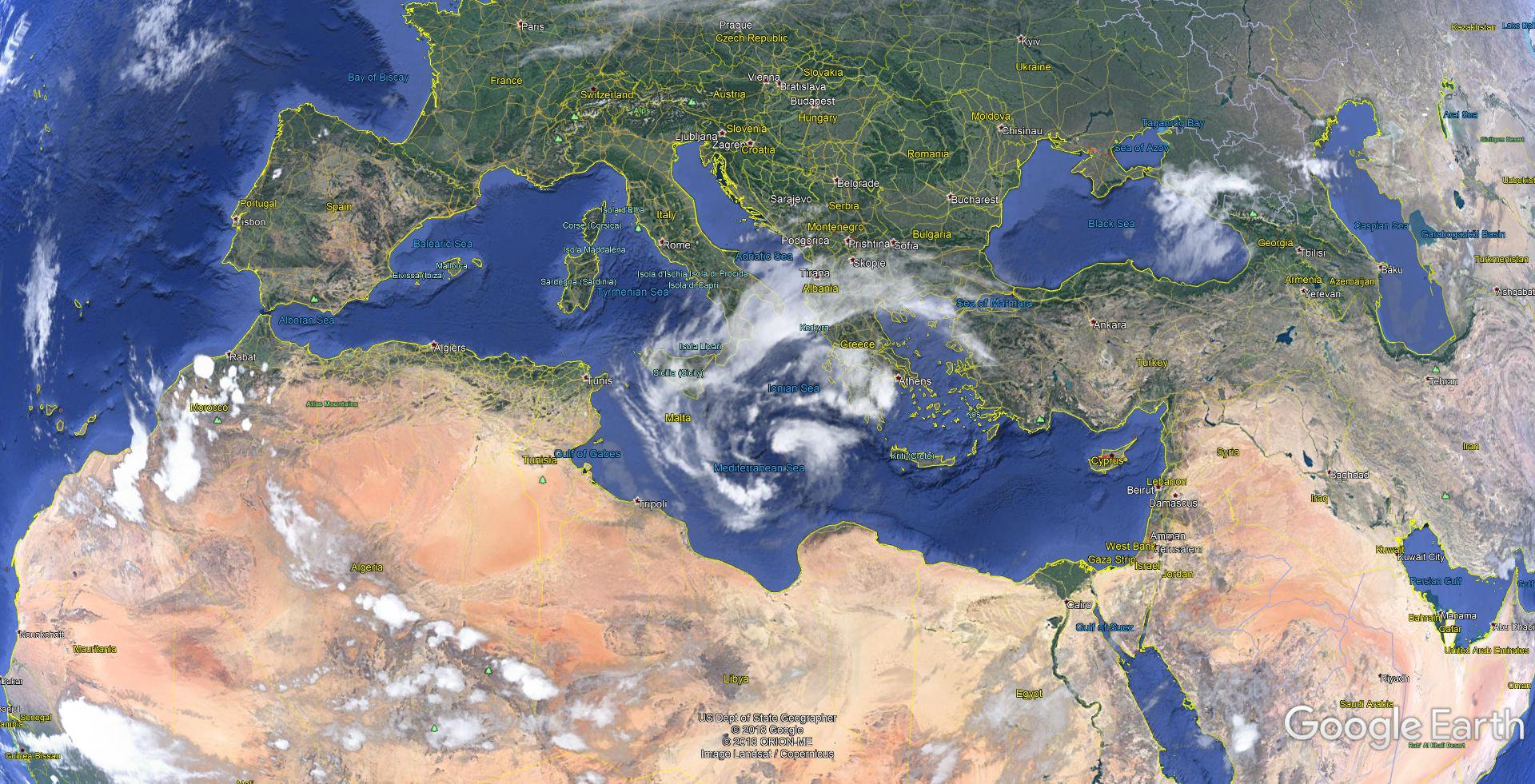
An uncommon type of storm known as a “Medicane” is swirling to life in the eastern Mediterranean Sea. The nickname—a portmanteau of Mediterranean and hurricane—is given to low-pressure systems that form over the sea and take on tropical or subtropical characteristics. Storms of this nature only form once or twice a year due to the Mediterranean sea’s cool waters.
The Medicane forming near Greece will bring several inches of rain, damaging wind gusts, and rough seas to the country and other parts of eastern Europe as it moves inland over the weekend. The storm’s size, strength, and winds—possibly gusting to 60 MPH at times—make it comparable to a tropical storm, and it’ll have similar effects to one as it makes landfall.
Medicanes have a lot in common with subtropical storms in the Atlantic Ocean. A subtropical cyclone is powered by different processes than a tropical cyclone, but they’re close enough in characteristics and impacts that they’re treated the same way by meteorologists. The National Hurricane Center names and issues forecasts for subtropical storms all the time—we’ve had quite a few of them in the Atlantic this year.
A tropical cyclone is a low-pressure system driven by strong thunderstorms packed around the center of the storm. The thunderstorms that power a tropical cyclone feed off of warm ocean waters for energy. The air in a tropical cyclone is uniformly warm through the entire storm.
A subtropical cyclone, on the other hand, derives some of its energy from upper-level winds. Thunderstorms and the strongest winds can be far removed from the center of the storm. The air throughout the storm isn’t always uniformly warm and tropical.
This Medicane formed from a feature known as an upper-level cut-off low. Active weather patterns can feature a jet stream that’s so wavy, the base of a trough can split off and develop into an upper-level low-pressure system. This upper-level low, now cut off from the rest of the jet stream, can sit and spin over the same area for days without any winds to steer it along. The presence of an upper-level low can lead to the development of a low-pressure system at the surface, and it’s that process that led to the Medicane’s formation.
While the storm has earned the name “Zorba” in some news reports, no agency is officially tasked with naming Medicanes as we would see with similar storms in the Atlantic or Pacific Oceans. Some other low-pressure systems in Europe are assigned names by national weather agencies; for instance, strong storms in the United Kingdom are officially named by the Met Office.
Tropical and subtropical cyclones are relatively rare in the Mediterranean because the water doesn’t get nearly as warm as you would find in the active parts of the Atlantic or Pacific Oceans. Some Medicanes have grown quite strong, though. Two such storms, one in 1995 and another in 1996, resembled full-fledged hurricanes as they formed south of Italy. This Medicane shouldn’t be as bad as previous storms, but just as we warn folks in the United States ahead of a landfalling system, it doesn’t take a strong storm to make a mess. Flooding and mudslides are possible in areas that see heavy rain, and gusty winds could topple trees and power lines.
