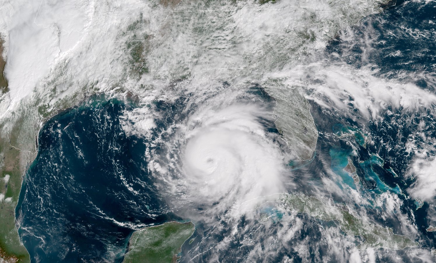

Hurricane Michael From Space on October 9
This post has been updated.
Hurricane Michael reached major hurricane status on Tuesday afternoon, and grew to a category 4 storm as it approached the Florida Panhandle on Wednesday. Widespread wind damage is likely where the eye makes landfall. For dozens of miles inland, and a life-threatening storm surge, flooding rains, and tornadoes are all possible as the storm makes its way into the southeast later this week. Governor Rick Scott tweeted on Wednesday morning that the time for safe evacuation had passed and that those along the coast should shelter in place immediately. Michael may hit land as the strongest hurricane the Panhandle region has ever seen, and prompted the National Weather Service Tallahassee to issue its first ever Extreme Wind Warning in anticipation of 130 MPH winds.
It didn’t take long for Hurricane Michael to get its act together. It grew from a disorganized tropical depression to a hurricane in about a day and a half, and its satellite appearance has improved dramatically with each passing hour. The storm developed a distinct eye on Tuesday morning, giving it that classic hurricane appearance as it gathered strength in the eastern Gulf of Mexico.

Hurricane Michael’s winds reached category three status on Tuesday with maximum sustained speeds of 120 miles per hour, with the environment ripe for the storm to continue strengthening over the next day. As of the NHC’s 10 a.m. update on Wednesday morning, Michael was a category 4 hurricane located 65 miles southwest of Panama City, with sustained winds of 145 miles per hour. Wind gusts at weather stations in Bald Point and Apalachicola were already close to 60 miles per hour.
Wind damage will be a significant concern with Hurricane Michael. Areas along and near the coast could see tornado-like damage from sustained winds of 100 miles per hour or higher, with even stronger gusts. The region that experiences the strongest winds in the hurricane’s eastern eyewall could see tornado-like damage as the storm pushes inland. Parts of Alabama and Georgia are also at risk. Actual tornadoes are also possible throughout the region.
The NHC expects the storm to maintain tropical storm strength as it passes north through the Carolinas on Thursday. This would expose hundreds of miles of land—stretching from Florida to North Carolina—to damaging winds. Fallen trees will block roads and damage homes and vehicles. Damage to power lines will leave hundreds of thousands—if not millions—of people without power for at least a little while after the storm. The hardest-hit areas may see power outages lasting a week or longer.
As we’ve seen so many times in recent years, it isn’t just the wind that will pose a danger to folks in the path of the storm. Heavy rain will accompany Hurricane Michael across the southeast. The storm will move quickly, which should stave off an epic flooding catastrophe like we saw with Florence or Harvey, but some parts of the Florida Panhandle, southeast Alabama, and central Georgia should see between four and eight inches of rain—with as much as a foot falling in some areas. A widespread swath of three to six inches of rain is possible elsewhere across the southeast. This much rain over a short period of time will lead to flash flooding concerns from Florida to North Carolina, especially in areas affected by Florence just a couple of weeks ago.
The concave coastline and flat, marshy terrain between Apalachicola and Cedar Key on Florida’s Big Bend makes storm surge a real threat. The unique geography allows landfalling storms to push seawater deep inland from strong, persistent onshore winds.
The National Hurricane Center expects a potential storm surge of up to 14 feet from Tyndall Air Force Base to Aucilla River, and up to 9 feet along other parts of the coast. You can check your area’s storm surge warnings here.
A storm like Michael is especially dangerous because it ramped up in a hurry. Forecasters had two weeks to watch Hurricane Florence wind up and get ready to drench the Carolinas, but it’s possible that news of this storm took people in its path by complete surprise, especially if they didn’t check weather forecasts over the weekend.
There’s not much time left to prepare, and it’s too late to evacuate, but if you are in Michael’s path you can find a list of tasks to complete before the storm arrives using Ready.gov’s hurricane preparedness checklist. Michael is expected to make landfall on Wednesday afternoon.
