What it's like to fly through Hurricane Florence
Hurricane Florence could come close to the United States next week—but for now, its path is highly uncertain. The hurricane is meandering into a complicated environment that makes it tougher than usual for meteorologists to figure out where the storm will go. While it’s still unknown whether the storm will affect the United States, residents along the East Coast have about a week to get ready just in case it turns toward land.
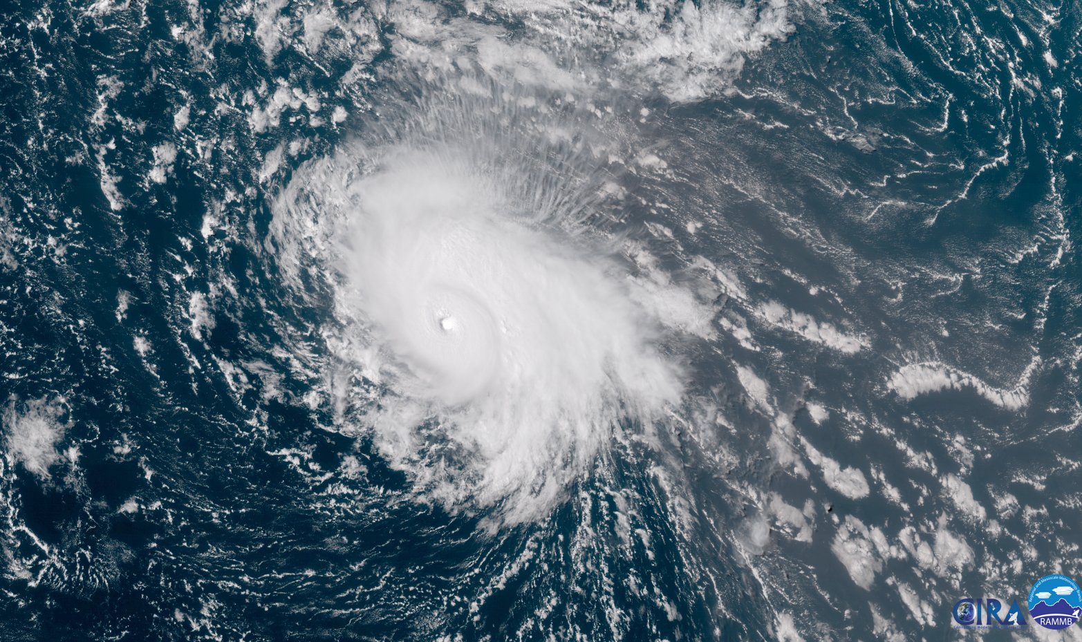
Florence is halfway across the Atlantic Ocean as of Thursday afternoon, swirling more than 2,000 miles from where it sprang to life off the western coast of Africa one week ago. The storm brought foul weather to the Cabo Verde Islands as it crossed into a more favorable environment for strengthening. It defied the odds on Wednesday to briefly balloon into a picture-perfect category four hurricane in the central Atlantic, strengthening far beyond what forecasters expected. The storm managed to insulate itself from surrounding dry air and strong winds that would otherwise have hindered its growth. Wind shear took its toll, though, and the storm has since lost some of its thunder.
Despite its shaggy appearance on Thursday afternoon, Florence is still a hurricane, and it should win-out against subsiding wind shear over the next couple of days. The latest forecast from the National Hurricane Center shows Florence regaining major hurricane status (category 3 or higher) as wind shear subsides and the storm approaches Bermuda early next week. What happens after it clears Bermuda, however, is still a bit of a mystery.
We can split hurricane forecasting into two categories: track and intensity. Thanks to improvements in weather models, forecasting methods, and the experience and skills of forecasters, track forecasting has improved dramatically even compared to just 10 years ago. Intensity forecasting is iffier—while wind forecasts are usually in the right ballpark, predicting rapid intensification of a storm is still a challenge.
No matter how good predictions have gotten, we still have to grapple with the fact that weather forecasts beyond about seven days aren’t all that accurate. Neither the science nor the technology is there yet to create a solid, accurate weather forecast beyond a week in advance. The best you can do that far ahead of time is recognize patterns and get a general idea of what could happen. That’s especially true for hurricanes, where even the smallest features in the atmosphere can have a tremendous effect on the eventual track and intensity of a storm. Florence is a perfect example of these limitations.

History and climatology both say Florence should curve out to sea. A quick look at all previous tropical cyclones that passed within 200 nautical miles of Hurricane Florence’s current position shows that each save for one—an unnamed storm back in 1901—recurved out to sea and never posed a serious threat to the United States. However, history is a guide rather than a rule. The atmosphere is fluid, and it acts accordingly. There are several factors influencing Florence’s eventual track, all acting to push and pull the hurricane closer to land or farther out to sea, and it’s too soon to tell which will prevail.
There’s currently a strong ridge of high pressure over the eastern United States. This is the ridge that’s keeping most everyone east of the Plains unusually warm and humid for early September, and the same ridge that’s forcing the remnants of Tropical Storm Gordon to dump flooding rains on the Midwest. This ridge will slowly break heading into the weekend as a trough in the jet stream dives south out of northern Canada.
This upper-level trough will also erode a ridge over the northern Atlantic that’s preventing Florence from racing north to its demise in cooler waters. The first uncertainty is the strength of the trough. If the trough is stronger and the ridge erodes quickly, the storm has better chances of curving back out to sea. If the trough is weaker, the hurricane could keep marching west, increasing the odds that it’ll affect the United States in some way.
A strong ridge of high pressure will start to build in place across the Northeast and eastern Canada early next week. If Florence keeps pushing toward the west, there’s a chance that the storm could essentially get blocked by that ridge and have little choice but to keep moving toward the U.S. East Coast.
We won’t know whether the odds of a U.S. impact are actually high until early next week. That’s an eternity when it comes to the weather. The major global weather models run several times a day. Weather balloons sample the atmosphere at least twice daily. NOAA will start running reconnaissance missions into the hurricane and atmosphere around it in a few days. All of that data gets fed into models and used by meteorologists to improve their forecasts, but we need to get a few days closer before it can tell us much.
It can be nerve-racking to follow every twist and turn of the weather models. Unfortunately, the deliberations of meteorologists and weather enthusiasts that used to happen in private now occur in daylight for everyone to follow on social media. This means that weather model graphics that could easily be wrong or misinterpreted catch fire on Facebook and Twitter as if they were official forecasts.
We’ll know more about Hurricane Florence’s future by this weekend. The best thing we can do right now is to watch and prepare. Make sure you stay up-to-date with the current forecasts by checking the National Hurricane Center a couple of times a day. If you live right on the coast, review what you’ll do if you’re told to evacuate due to storm surge flooding—the biggest killer in landfalling storms. Make plans for what to do if hazardous weather keeps your kids home from school, prevents you from going to work, or floods nearby roads and prevents you from getting around town.
It’s a good idea to stock up on emergency supplies even if you live hundreds of miles away from the coast. Good supplies to have are canned and prepackaged foods you don’t have to cook, bottled water, medicine, batteries, physical flashlights (not the feature on your cell phone), and a little bit of cash if you can swing it. Power outages can last for days after a tropical system makes landfall, and you truly don’t realize how much you use electricity until it’s gone.
