This article was originally featured on Knowable Magazine.
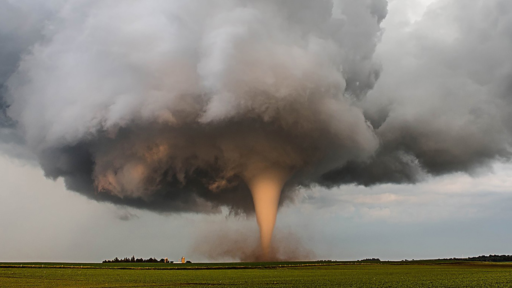
One muggy day in July 1986, a news helicopter was recording footage of a festival in Minneapolis when the pilot and photographer glimpsed a tornado over nearby Brooklyn Park. They moved toward it, filming the powerful twister for 25 minutes, mesmerizing viewers watching it live on TV.
Watching as the helicopter hovered within maybe a half-mile of the twister was Robin Tanamachi, who was a kid growing up in Minneapolis at the time. “We were seeing all this really beautiful interior vortex structure,” she says. “I was just absolutely hooked on that, and I know I was not the only one.” Today, Tanamachi is a research meteorologist at Purdue University in West Lafayette, Indiana, and one of many researchers delving into twisters’ mysteries, searching for details about their formation that may bolster future forecasts.
Tornadoes can be elusive research subjects. Through chasing storms and using computer simulations, scientists have worked out the basic ingredients needed to spin up a twister, but two crucial questions continue to vex them: Why do some thunderstorms form tornadoes while others don’t? And how exactly do tornadoes get their spin?
Despite the logistically and scientifically challenging nature of the work, scientists are motivated to keep trying: Tornadoes can kill dozens to hundreds of people in the United States every year and cause billions of dollars in damage. Now researchers are chasing the killer storms that spawn tornadoes with cutting-edge technology, flying drones into the storms and harnessing more computing power than ever to simulate them in search of answers.
“Today, we’re simulating the atmosphere with unprecedented spatial resolution. We’re observing storms with unprecedented temporal and spatial resolution,” says atmospheric scientist Howie Bluestein of the University of Oklahoma in Norman. “But there’s still a lot of problems and a lot of things that need to be solved.”
Scientists may be turning up new clues to tornado formation by studying what’s happening in the atmosphere around them and on the ground below them, and by comparing what they find in the field with new, higher-resolution models of the thunderstorms that generate them. Even as they chase these new leads, researchers are also trying to understand how climate change may affect when and where tornadoes form.
Chasing answers
Since scientists began studying tornadoes in earnest in the mid-20th century, they’ve put together a pretty good outline of the steps required to generate a twister. Most destructive tornadoes are spawned by supercell thunderstorms — giants that typically have a very tall cloud that widens into an anvil shape at the top. Supercells are characterized by a kilometers-wide rotating updraft called a mesocyclone that can last for hours. That rotation comes from wind shear, which sets wind nearer to the ground spinning horizontally like a spiraling football. These winds then become vertically oriented within an updraft like a spinning top.
A couple of things need to happen for a supercell to become tornadic: First, the giant mesocyclone at the heart of the storm needs to get air rotating closer to the ground. Then this vortex needs to be stretched upward. Stretching tightens the twister’s footprint, speeding its rotation, similar to what happens when figure skaters pull in their arms during a spin.

The first clues to the physics of tornadoes came from secondhand information and damage reports, as scientists tried to figure out what sorts of winds could blow down a barn or pluck a chicken, says Richard Rotunno, an atmospheric scientist at the National Center for Atmospheric Research in Boulder, Colorado, and the author of an overview of the fluid dynamics of tornadoes in the 2013 Annual Review of Fluid Mechanics.
The construction of the Interstate Highway System in the 1950s created a grid across the flat Great Plains that allowed enterprising scientists to get out in front of storms and sometimes directly observe tornadoes. A big advance came with the development of Doppler radar for meteorology. By emitting pulses of energy and detecting the reflected signal, the technology captures information about wind and precipitation. Radar allowed the detection of mesocyclones, which became the basis for tornado forecasts and a boon for chasers, who would stop at payphones periodically to call the lab for the latest radar intel.
But radar doesn’t catch all the clues scientists are after—such as the invisible forces in a storm that get winds moving—so they turned to models that simulate the physics of storms, says atmospheric scientist Paul Markowski at Penn State University in University Park. “In a computer simulation, we have all of those forces.”
The first three-dimensional simulations of supercells were created in the 1970s, helping scientists study the structures of updrafts and downdrafts and how precipitation evolves. As models improved over time, they revealed that updrafts can turn rotating areas of air into the massive mesocyclones in supercells. The models also showed how thunderstorms in the Northern Hemisphere can split into a left and a right cell, with the right one more likely to result in severe weather. These models were finally reproducing behavior observed in actual supercells and providing hints to how areas of cooler air, called cold pools, might play into tornado formation by shortening the time it takes for a twister to develop.
These models had relatively coarse resolution, but as computational power increased, simulations started to capture more detail about supercells, and researchers also worked to realistically capture the effects of rain, snow and hail. Still, the resolution was on the order of hundreds of meters—far too large to catch tornadoes, which tend to be closer to 20 meters wide.
Radar also got better and faster, and researchers started taking it into the field on trucks. In 1994, a host of scientists hoping to understand where tornadoes got their rotation began a multiyear campaign named Verification of the Origins of Rotation in Tornadoes Experiment, or VORTEX. They chased storms with all sorts of equipment, including sensor-loaded weather balloons, and instrumented cars that took temperature, pressure and wind measurements within supercells. But the scientists felt they needed further observations, leading to VORTEX-2 in 2009. “The big takeaway that we got from VORTEX-2 was that you can’t really tell whether a storm is going to be tornadic or non-tornadic just by how it looks on radar or what the weather balloons in its proximity show you,” Tanamachi says.

Other field campaigns followed, but scientists still haven’t definitively answered why some supercell thunderstorms create tornadoes while others don’t progress beyond a mesocyclone. Now they are looking to new strategies and tools to fill in the rest of the story.
Send in the drones
Despite the drama of a churning twister, the center of a tornado probably isn’t where the answers lie. “Getting something into the tornado—it makes for good television, but it actually doesn’t tell us a whole lot,” Markowski says. “It tells us that it’s windy there and the pressure is low.”
Instead, scientists are using new tools to glean clues from the environment that could help them sift the tornadic supercells from the non-tornadic. “Detailed data on the structure of the atmosphere—its temperature, pressure, wind—below cloud base is largely absent,” Rotunno says. Researchers are starting to fly drones into storms to capture these observations.
Drones can take detailed measurements at higher altitudes than cars. And unlike weather balloons, they can cross boundaries between areas of a storm with different pressure or air density. “The reason we think they’re important is because tornadoes tend to form on these boundaries,” says atmospheric scientist Adam Houston of the University of Nebraska-Lincoln. Houston and his colleagues have been pairing drone observations with radar and other techniques in the field as part of the TORUS project since 2019. Now Houston’s team is digging through the data, looking for trends across storms for hints about whether these relatively small features influence tornado formation.
Scientists are also gathering information on what’s going on near the ground where the tornado forms. Both modeling and observations have shown that this is where the highest speeds occur. How air interacts with the land surface—features such as hills and forests—may play a role in starting and intensifying twisters, but radar tends to miss at least the first hundred meters just above the ground because of the geometry of the beam. Atmospheric scientist Jana Houser of Ohio State University in Columbus is hoping to learn more about what’s going on in that gap.
Houser’s team chases storms, capturing radar measurements of a tornado’s size and intensity over time. Then they search for links between those data and the topography and roughness of the surface the storm has swept over. They’ve found that in most cases, changes in terrain affect the air getting sucked into the tornado and change the twister’s strength. This could be an important clue, but it’s proving difficult to puzzle out. “The problem,” Houser says, “is that sometimes the same type of occurrence in one case results in an intensification, and then in the next case, it results in a weakening.”
There may be a limit to how well researchers can understand and predict these storms, Markowski says. “When it comes tornadoes, I think we’re kind of butting up against chaos.” Perturbations that are so small they are essentially unmeasurable are everywhere in the atmosphere and may influence the formation of a tornado. Markowski and other scientists are starting to use machine learning to help better predict how these storms behave.
Finding the twist
Another big question has been swirling around twisters for decades: “We really don’t understand where the rotation that feeds the tornado ultimately comes from,” Houser says. The rotating air in a supercell’s mesocyclone is too high by the time it starts spinning vertically; the storms need additional rotation nearer to the ground to become tornadic. There are at least three hypotheses as to where this near-ground rotation comes from and, in any given twister, there may be multiple mechanisms at play, she says.
One hypothesis is based on how friction slows air moving near the ground. Air at higher altitudes moves faster and tumbles over the slower air and starts rolling like a barrel. The idea is that this rotating air could then be turned upright when it gets sucked into an updraft. Other hypotheses point to downdrafts related to precipitation and cooling air. The difference in density between cool air and neighboring warmer air can generate an air current that prompts spinning. Both observations and models have backed this idea and point to different areas of the storm where this may occur.
During either of these scenarios, there may also be many smaller pockets of swirling air that merge, combining into an area with enough rotation to get a tornado spinning. New support for this theory is emerging through higher-resolution storm simulations.
Most models working at coarser resolutions can’t actually see simulated tornadoes, inferring them instead based on areas of air with a lot of spin. Atmospheric scientist Leigh Orf of the University of Wisconsin-Madison has taken advantage of advances in supercomputing to build 10-meter-resolution models that can directly simulate tornadoes. At this scale, turbulence comes alive, Orf says. His models reveal how small areas of rotation could combine to kick off a tornado. “It fully resolves non-tornadic vortices that merge together in ways that are very compelling and I’ve never seen before,” he says.
Models can also provide hints of behavior to look for in the field. Orf’s models have helped him and his colleagues explore a feature they named the streamwise vorticity current, or SVC—a tail of swirling air off to the side of the storm that may amplify air rotation near the ground. Other scientists have now observed this feature in actual tornadic supercells.
Real-world observations don’t yet exist for the rotation mergers, but they may be coming. Plans to revamp the US radar system would employ a new generation of faster radar that can capture features that develop in a flash. “I am very confident that the things I’m seeing in the simulations will eventually be detected in the atmosphere, just like the SVC was,” Orf says.
High stakes
The landscape of tornado research has expanded from the Great Plains into the southeastern United States, driven by deadly storms and increasing tornado activity there. When a rash of tornadoes hit the region in 2011 starting in mid-April, more than 300 people were killed. “It was the largest outbreak on record since the super outbreak of 1974,” Tanamachi says. That motivated another campaign in 2015, VORTEX-SE, to study tornadoes there, but the work has proved difficult.
Not only do atmospheric conditions in the Southeast differ from the Great Plains, it’s also harder to observe twisters, Tanamachi’s team found. The hilly landscapes block views of storms, mucking up storm-chasing efforts. Instead, researchers have to forecast where a tornado might form and hunker down there. The one time this approach yielded a tornado sighting during VORTEX-SE, the radar was blocked by a stand of trees.
Much of what scientists have learned about tornadoes elsewhere doesn’t apply to the Southeast because many of the tornadoes that occur there are not seeded by supercells. Instead, they grow from a line of storms called a squall line. “We have no clue how these work,” says atmospheric scientist Johannes Dahl of Texas Tech University in Lubbock. While these tornadoes are typically weaker than those from supercells, they can still cause damage and death.
Despite the challenges, understanding tornadoes in the Southeast remains a priority, especially as tornado activity has kicked up in the region in the last four decades or so. It’s not clear yet if this is due to climate change or something else, such as the climate pattern known as El Niño, Dahl says. Still, researchers have started to see some trends related to climate. A look at 60 years of US tornado data revealed that while the number of tornadoes didn’t change, the number of days on which multiple twisters occur has increased. Climate change appears to be aiding some of the ingredients for tornadoes at the expense of others. But it seems that on a good day for tornadoes, the conditions are very favorable, Houser says.
With increasingly powerful models, a possible upgrade to the US radar system and the help of machine learning, researchers will continue in their quest to unveil the inner workings of tornadoes. “Although research in this area has been going on for decades,” Dahl says, “it always seems like there are surprises.”
Even after 20 years of studying tornadoes, Houser finds herself “giddy, excited” by the prospect of catching a tornado in action — ideally over a field where it isn’t destroying someone’s home. “There’s this weird dichotomy between the beauty that they have and the volatility and intensity and violence that they wreak,” Houser says. “They’re so mysterious.”
This article originally appeared in Knowable Magazine, an independent journalistic endeavor from Annual Reviews. Sign up for the newsletter.
