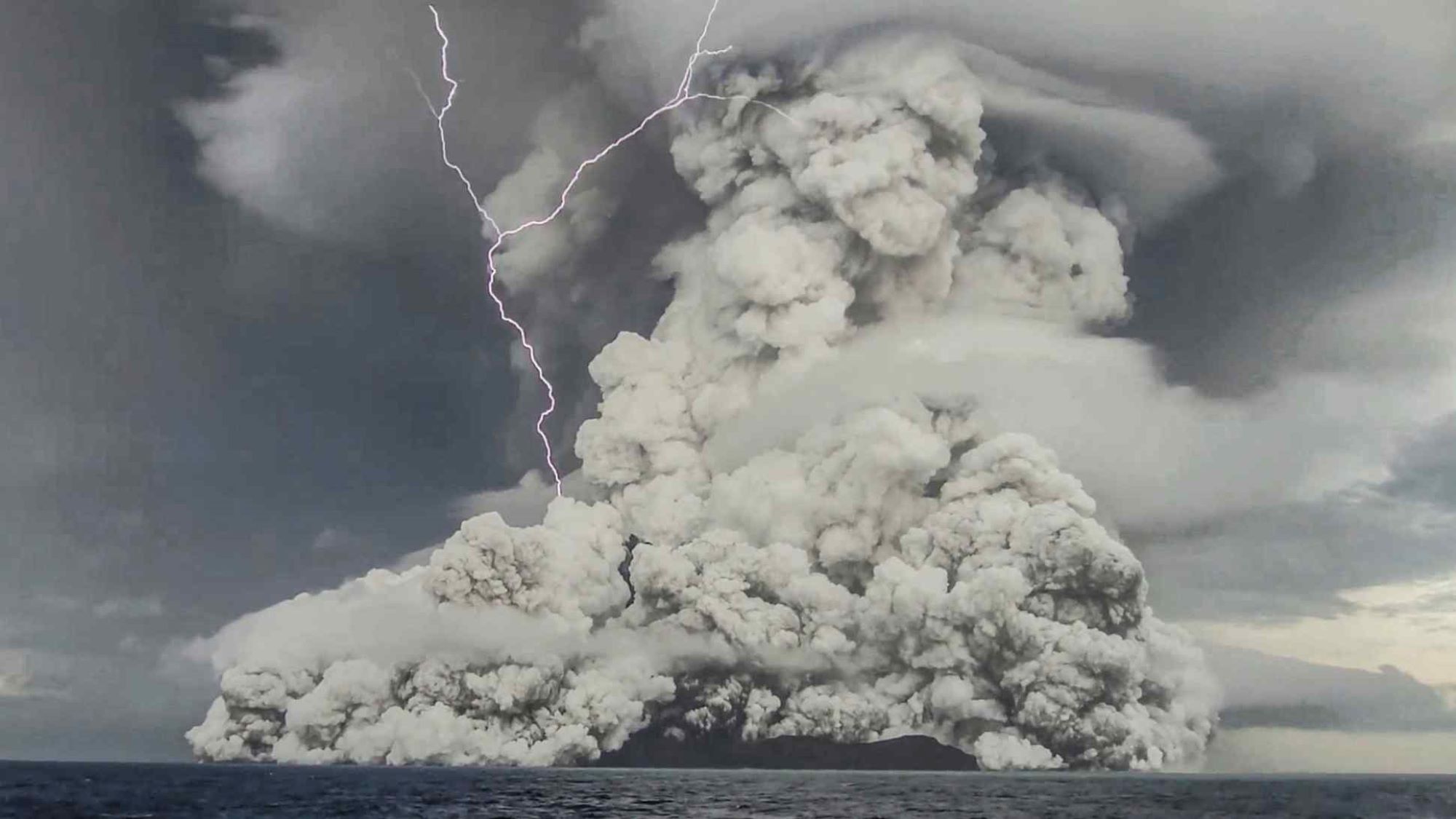
On January 15, 2022, the drowned caldera under the South Pacific isles of Hunga Tonga and Hunga Haʻapai in Tonga blew up. The volcanic eruption shot gas and ash 36 miles up into Earth’s mesosphere, higher than the plume from any other volcano on record. The most powerful explosion observed on Earth in modern history unleashed a tsunami that reached Peru and a sonic boom heard as far as Alaska.
New research shows that when the huge volume of volcanic ash, dust, glass fell back into the water, it reshaped the seafloor in a dramatic fashion. For the first time, scientists have reconstructed what might have happened beneath the Pacific’s violently strewn waves. According to a paper published in Science today, all that material flowed underwater for dozens of miles.
“These processes have never been observed before,” says study author Isobel Yeo, a marine volcanologist at the UK’s National Oceanography Centre.
About 45 miles from the volcano, the eruption cut off a seafloor fiber-optic cable. For Tongans and rescuers, the broken cable was a major inconvenience that severely disrupted the islands’ internet. For scientists, the abrupt severance of internet traffic provided a timestamp of when something touched the cable: around an hour and a half after the eruption.
The cut also alerted scientists to the fact that the eruption had disrupted the seafloor, which isn’t easy to spot. “We can’t see it from satellites,” says Yeo. “We actually have to go there and do a survey.” So in the months after the eruption, Yeo and her fellow researchers set out to fish clues from the surrounding waters and piece them back together.
A Tongan charter boat owner named Branko Sugar had caught the initial eruption with a mobile phone camera, giving an exact time when volcanic ejecta began to fall into the water. Several months later, the boat RV Tangaroa sailed from New Zealand to survey the seafloor and collect volcanic flow samples. Unlike in much of the ocean, the seafloor around Tonga had already been mapped, allowing scientists to corroborate changes to the topography.
[Related: The centuries-long quest to map the seafloor’s hidden secrets]
The scene researchers reconstructed, had it unfolded above ground, might fit neatly into Roland Emmerich disaster film. The volcano moved as much matter in a few hours as the world’s rivers delivered into the oceans in a whole year. These truly immense flows traveled more than 60 miles from their origin, carving out gullies as tall as skyscrapers.
When the volcano blew, it spewed out immense quantities of rock, ash, glass, and gas that fell back to earth. This is bog-standard for such eruptions, and it typically produces the fast-moving pyroclastic flows that menace anything in their path. But over Hunga Tonga–Hunga Haʻapai, that falling mass had nowhere to go but out to sea.

“It’s that Goldilocks spot of dropping huge amounts of really dense material straight down into the ocean, onto a really steep slope, eroding extra material,” says Michael Clare, a marine geologist at the National Oceanographic Centre and another author. “It bogs up, it becomes more dense, and it just really goes.”
Scientists estimated the material fanned out from Hunga Tonga–Hunga Haʻapai at 75 miles per hour—as fast as, or faster than, the speed limit of most U.S. interstate highways. If correct, that’s 50 percent faster than any other underwater flow recorded on the planet. That rushing earth gushed back up underwater slopes as tall as mountains.
“It’s like seeing a snow avalanche, thinking you’re safe on the mountain next to it, and this thing just comes straight up against you,” says Clare.
These underwater flows, according to the researchers, had never been observed before. But understanding volcanic impacts on the seafloor is about more than scientific curiosity. In the last two centuries, we’ve laid vital infrastructure below the water: first for telegraph cables, then telephone lines, and now optical fibers that carry the internet.
Trying to prepare a single cable for an eruption of this scale is like trying to prepare for being struck by a train—it can’t really be done. Instead, a surer way to protect communications is to lay more cables, ensuring that one disaster won’t break all connectivity.
[Related: Mixing volcanic ash with meteorites may have jump-started life on Earth]
In many parts of the globe, that’s already the case. Fishing accidents break cables all the time, without much lasting effect. If, for instance, the world experienced a repeat of the 1929 earthquake-induced landslide that cut off cables off Newfoundland, we probably wouldn’t notice too much: There are plenty of other routes for internet traffic to run between Europe and North America.
As a global map of seafloor cables shows, though, that isn’t true everywhere. In Tonga in 2022, a single severed cable all but entirely cut the archipelago off from the internet. Many other islands, especially in the developing world, are similarly vulnerable.
And those cables are of great value to geologists, too. “Without having the cables, we’d probably still be in the dark and wouldn’t know these sorts of events happen on the scale that they do,” says Clare.