This article was originally featured on Undark.
On an overcast day in September, Heidi Geagel negotiates familiar potholes on a gravel road in Seldovia, Alaska. Cresting a hill topped with a small chapel, her town spreads out below — in the bay, gently rocking fishing boats; onshore, the Linwood Bar & Grill, the Crab Pot Grocery, and a couple dozen homes on stilts.
Geagel, Seldovia’s city manager, turns around to three people sitting in the back seat, who partner with the United States’ National Tsunami Hazard Mitigation Program and have traveled in from Anchorage and Fairbanks for a meeting with community leaders about tsunami hazards. She points out how much of the landscape could be underwater if one of the giant, fast-moving waves were to hit: “Pretty much the entire map of Seldovia is in the inundation zone, except for this hill.”
Alaska is uniquely vulnerable to two types of tsunamis. The first, tectonic tsunamis, are linked to the long string of volcanic islands that curves like a tail from the state’s southern tip; these islands mark the northern edge of the Ring of Fire, a geologically active zone that generates approximately 90 percent of the world’s earthquakes. Tracing those islands, deep under water, is the Alaska-Aleutian subduction zone, a trench where vast plates of hard rock overlap and friction slowly builds. Once or twice a year, the subduction zone generates earthquakes strong enough to trigger tsunami alerts; every 300 to 600 years or so, it ruptures in a megaquake that sends devastating tectonic tsunamis to Alaska’s shores.
The state’s 34,000 miles of wild shoreline make a second, lesser-known type possible, too: landslide tsunamis. Alaska’s southern coast is lined with active volcanos and hundreds of fjords ringed by unstable cliffs and, in the deep water below, a thick layer of silty sediment. Relatively small earthquakes, common in Alaska, shake that unstable landscape, causing landslides above and below sea level that displace massive volumes of water. The resulting tsunamis may hit coastal communities within minutes. And as climate change accelerates glacier melt and the subsequent erosion in those regions, those landslide tsunamis are increasingly likely.
The mix of hazards means that “in Alaska, we have the capability to have a very bad day,” as state earthquake geologist Barrett Salisbury, one of the tsunami scientists, puts it.

This story was supported by the Pulitzer Center.
Seldovia sits about 137 miles as the crow flies southwest of Anchorage on the tip of the rugged Kenai Peninsula, directly above where the tectonic plates meet. It’s one of 159 communities that dot Alaska’s coast, including tourist hubs that host 4,000-passenger cruise ships, tiny Russian Orthodox villages, and the settlements of many of Alaska’s 228 federally recognized Indigenous tribes. Small and isolated, it’s a case study for the layers of complexity that make Alaskan communities especially vulnerable.
It’s hard to plan for a tsunami. Tsunami science is practically in its infancy, having only emerged as computer modeling became possible in the 1980s. Scientists in Alaska lack the technology required to forecast tsunamis before they hit the state because they simply happen too quickly. For many Alaskans, the state’s last major tsunami, which hit in 1964, is a distant memory. False alarms cause evacuations at least once a year, leaving people to wonder why they must leave without any waves to show for it. Those challenges are compounded by a culture that can be wary of outside experts.
“I know the history,” says Elena Suleimani, a tsunami modeler on the state team, who works at the Alaska Earthquake Center at the University of Alaska Fairbanks. “I know every single detail of what happened in ’64. And the people who live there, they don’t.”
As community leaders and scientists prepare for the next big wave, they struggle with a perennial question: How can they convince people they’re at risk from a disaster that’s unpredictable, can skip many generations, and is guaranteed to be catastrophic when it comes?

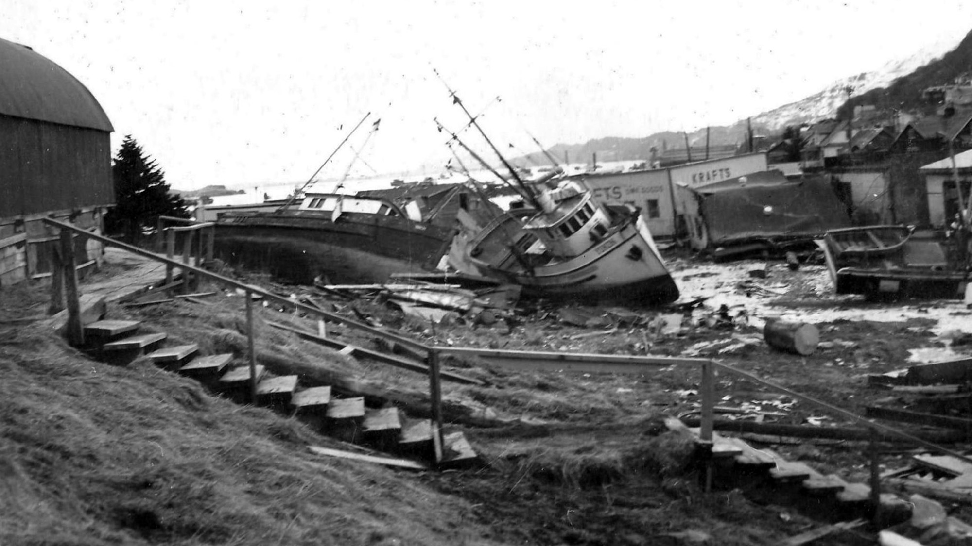
On March 27, 2964, the second largest earthquake in recorded history, magnitude 9.2, struck off Alaska’s southern coast. Streets in Anchorage cracked in half and a whole neighborhood fell into the sea. Within minutes, the underwater slopes along parts of the shoreline failed, generating local tsunamis.
Then, the tectonic tsunami hit, inundating communities repeatedly for hours. More than 20 tsunamis struck Alaska in all, killing 106 people across the state and causing $284 million in damage. In Seldovia, the ground shook for about three minutes, then permanently sank by 3.5 feet. The highest wave of the tectonic tsunami that reached the town, at 26 feet, wasn’t itself significant, as it arrived at low tide. But on the next extreme high tide, the town was underwater and had to be raised and rebuilt.
Tsunami science is practically in its infancy, having only emerged as computer modeling became possible in the 1980s.
Darlene Crawford, a Seldovia Village Tribe elder, remembers holding the cupboards shut as her house shook around her, seemingly for an eternity, then herding her four young children up a hill to high ground on that cold March evening. The effects of the Good Friday Earthquake linger today, she said — the urban renewal project to raise the town divided the community, and only one cannery returned, transforming the crab fishing-based economy. “It really changed life in Seldovia,” she said. “The town was blank for quite a while.”
Still, Seldovia fared better than most, in part because the town faces the sheltered Cook Inlet. On the opposite side of the Kenai Peninsula, facing the open ocean, communities like Seward, where Crawford’s parents lived, weren’t so lucky. There, waterfront warehouses and fuel storage tanks slid into Resurrection Bay, then were returned to shore within minutes by fiery waves more than 30-feet high. The Alaska Native village of Chenega, on an island near Seward, lost a third of its population and was never resettled. Its residents initially scattered across Alaska before building a new community on a nearby island.
Next time, Seldovia might not be as lucky. Tsunamis are as unpredictable as they are inevitable. And if the next megaquake strikes at high tide, the waves could wipe Seldovia off the map.
Inside tribal headquarters in downtown Seldovia, at the meeting with community leaders, the Alaska tsunami team huddles over a glossy town map. A jagged red line circles the town’s inundation zone. City and tribal officials lean over for a closer look at their community underwater. Today’s goal is to create a second, yellow line to define an evacuation zone. The state experts guide the process, but, mindful of the delicate politics, they start the meeting by emphasizing that this map, and this process, belong to the community leaders.
“It’s all up to you how we’re going to make it,” says Suleimani. “You work with us, we have the funds, but you design it.”
The approach sits well with Mark Ball, emergency manager for the Seldovia Village Tribe, who later told Undark: “We have our traditions, but we’re very keen on harnessing new technologies that come in. And so we’re open to having experts come in and present what they have. Now, there may be questions as far as how we’re going to take that information based on local knowledge. But working together, instead of completely dismissing it, we’re very open to that.”
The yellow evacuation line is based on the red line — the initial inundation map, which Suleimani generated using a supercomputer at the University of Alaska Fairbanks. The computer crunches numbers on hypothetical tsunami sources and the resulting waves to determine worst-case scenarios. But tsunamis don’t map neatly to streets or property lines.
Meanwhile, evacuation is no small feat, as Seldovia is accessible only by boat and small plane. The size of the community changes with the season, too. Although there are only about 500 permanent residents, hundreds of tourists and part-timers arrive in the quaint Alaskan fishing community each summer.
Many people have a stake in the results of the evacuation zone meeting: The city, borough, and state governments, as well as the tribal government, the Seldovia Native Association, Inc., and private landowners. In the conference room, the dynamics are just as complex. “You could spend like eight hours talking about the history of all of the interpersonal relationships in this room,” says Bretwood Higman, a local independent geologist, whose new elevation maps brought the state tsunami team here in the first place. “This is a small town.”
The debate begins. Suleimani, Salisbury, and Anthony Picasso, the team’s emergency manager, field questions. Should houses on small downtown hilltops be marked as safe zones? Or just the Seldovia school, which is farther away and the designated evacuation center, equipped with water, medical support, and a generator? If those houses are marked as safe, tourists might show up at residents’ doorsteps, seeking refuge or medical care residents are unequipped to provide. But if people have to cross the inundation zone to reach the school, they could risk their lives. There would be time to get there if a tectonic tsunami triggers the town’s siren, but not if a nearby quake sparks faster, local tsunamis.
Laurel Hilts, a tribal official, points out that Seldovia’s residents don’t always bother to learn their street names or house numbers, which will make labeling the map difficult.
A city councilmember, Harmony Payton, turns to Salisbury: “Are we just here to tell you that we don’t know how to read street signs, or…” She trails off and everyone laughs, but the tension is clear.
Salisbury strokes his long beard. “The big picture is, we need to know the approach you want to take to deal with the fact that the yellow line is not the red line, and they’re not going to be in the same place,” he says. “These are not the types of decisions that are made in a one-hour meeting.”
Crystal Collier, the tribe’s president, later told Undark that while she believes mapping is beneficial, it also creates a lot of stress for people when they see that their home is in the inundation zone. Collier was 4 years old when her mother hauled her to high ground in ’64 in that chaotic evacuation. “So the tribe spends a lot of time trying to educate people on making good decisions.”
Ultimately, the state tsunami team deems the Seldovia meeting productive, and the community leaders come away with evacuation options to bring to the next city council and tribal meetings. That’s how it’s been in many coastal communities, especially those devasted in 1964, or tribal ones with memories of tsunamis captured in oral histories going back much further.
It hasn’t always gone so well. For communities that were left unscathed in ‘64 — widely and falsely thought to be the worst-case scenario — it was originally much harder to convince people of the risk. After the 2004 tsunami in Indonesia, which killed over 220,000 people, 66 more Alaskan communities requested maps. But interest waned again. Then the work got even harder after the 2011 Tohoku tsunami in Japan, which made scientists rethink how they modeled tsunamis — not an uncommon issue in such a young field. That meant Alaska’s evacuation maps had to be updated, and Alaskans weren’t entirely sure why they had to go through the process again.
“These are not the types of decisions that are made in a one-hour meeting.”
Even in Seldovia, there’s some resistance to evacuation, thanks to what feel like frequent false alarms. Every time the tsunami siren sounds, often in the middle of the night, dozens of sleepy residents and bewildered tourists end up at the Seldovia school, waiting hours for the warning to be cancelled.
But not everyone evacuates, Geagel says: “We also now, with this ‘cry wolf scenario’ have individuals that are very much in the inundation zone who aren’t even going to get out of bed.”
There’s “no such thing as a false alarm,” insists Dave Snider, the Tsunami Warning Coordinator at the National Tsunami Warning Center, which is around a 300-mile drive from Seldovia in Palmer, Alaska. The center houses an earthquake monitoring system — rows of computer monitors that show seismometer data worming across the screens — and servers for a tsunami modeling system. A low hum comes from a nearby row of phones, direct lines to the Federal Emergency Management Agency and the Pacific Tsunami Warning Center.
Usually, the center is quiet. But if a seismometer detects the rumble of an offshore earthquake, magnitude about 7 or greater, it triggers a cascade of data and forecasts. The quickest, roughest modeling takes about nine minutes, but the warning center has just five to decide whether to issue a warning. In those critical five minutes, scientists lack key information that determines whether a wall of water is hurtling toward shore at 500 miles per hour — or not.
When it does issue a warning, individual regions then have to decide whether to sound their sirens and the National Weather Service has to transmit the warning to federal emergency alert systems. (Due to the patchwork coverage by local and third-party warning systems, warnings sometimes go to larger geographic areas than intended.) In the meantime, the 20-person warning center staff, which serves the entire continental coast of the United States and Canada, can be overwhelmed with calls from worried Alaskan community emergency managers.
“Telling people to get up at two o’clock in the morning and head for the hills is always, do you push that button or not, you know?” says Terry Nichols, a physical scientist at the center. “But we typically err on the side of safety.”
Snider nods, adding: “And our emergency management people up and down the coast get really frustrated at this point, because they want a yes or no answer.”
It takes another hour or more to collect enough data to cancel a warning. But that all clear message also leaves Alaskans frustrated. “That gives the sense of that false alarm, because we haven’t totally closed that loop of telling the story,” Snider later said. “We didn’t tell you how the story ended, we just told you that the killer was standing outside the house, but then you’re left wondering, did they come to the door or not?”
“Telling people to get up at two o’clock in the morning and head for the hills is always, do you push that button or not, you know?”
Technologies for better tsunami detection exist: A network of deep-ocean sensors, called DART buoys, line the Alaska-Aleutian subduction zone that runs parallel to the state’s coast. But while those buoys, and a network of tidal gauges, help the warning center cancel alerts when no tectonic tsunami is ultimately detected, as an early warning system, it only protects the Lower 48 states. The buoys are on the ocean side of the zone, which means when an earthquake there sends out tsunamis in both directions, by the time the buoys detect a wave heading to the open ocean, the wave heading the other direction may have already hit Alaska’s coast.
And the warning center has no way of detecting, much less predicting, landslide tsunamis. “We’re designed to warn the outer coast. But a lot of people, maybe even most people, live in those inside waterways, like the Upper Cook Inlet,” Snider says. “We don’t model well for that, we don’t alert and communicate well on those problems. And that’s where the people are.”
Earlier on that September day in Seldovia, Suleimani had led the tsunami team to the school on the hilltop, past a blue evacuation shelter sign and into a classroom of teenagers. Salisbury and Picasso follow, hauling copies of a children’s book about the aftermath of the 2011 Tohoku tsunami.
In 1964, shocked Seldovians made their way to the school, fearing a tsunami. It’s been the evacuation center for as long as community members can remember. Suleimani has wanted to give this lecture since 2002, in order to educate younger residents about tsunamis. But until now, it’s been difficult for her to stay in Seldovia long enough to make it happen.
“You probably had several tsunami warnings recently and nothing happened, right?” she asks the students. “And you think, ‘What’s the problem with those scientists, they can’t figure out what to do.’”
She starts with the basics, explaining how scientists can’t predict earthquakes but they can predict tectonic tsunamis — so no one should die in them. She covers the complexity of making those predictions. She makes sure the students know that they are sitting in their evacuation shelter. She tells them about the “Angel of the Beach,” a 10-year-old who convinced a Thai beach resort to evacuate before the 2004 tsunami hit Thailand.
Suleimani’s perpetual challenge is getting Alaskans to see the world as she can’t help but see it. To walk through downtown Seldovia and imagine it underwater. To get people to a feel a bit of that nagging fear she feels. That a wave could come at any time. To let that vision of Alaska guide their daily decision-making, jolt them into taking warnings seriously and learning more.
After handing out books and weather radios, the team walks out into the relative warmth of an Alaskan late-summer day. Geagel’s SUV eases into the lot to pick them up. She asks how it went.
“I usually don’t expect more than two, three kids paying attention,” Suleimani says. But that’s enough. As long as it’s on a couple minds. Maybe they’ll talk to their parents. If a tsunami comes, maybe they’ll be the angel of their own local beach — that’s her hope.
“They may be drawing or doodling, but they’re hearing stuff,” Salisbury says. “At least now they might think, ‘Oh I need to run.’ Basically, that’s the one thing we want them to know, if there’s a big earthquake you need to go.”
Christian Elliott is a science and environmental journalist based in Illinois.
