While SEAL Team 6 descended upon Osama Bin Laden’s compound in Abbottabad, Pakistan in 2011, they used hyperspectral imaging to gain an edge in nighttime urban combat. But China is soon bringing that advantage to space, preparing to launch the world’s most powerful hyperspectral imaging satellite.

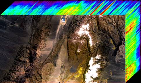
Electro-optical devices like cameras and infrared sensors generally observe only one band in the electromagnetic spectrum, i.e. cameras observe the band visible to human eyesight and infrared cameras view the infrared band. Hyperspectral cameras and sensors, on the other hand, can simultaneously view hundreds of electromagnetic bands for a single image, building a layered ‘cube’ of the image in different electromagnetic wavelengths. The use of such a wide range of wavelengths provides the ability to observe objects which conceal their emissions in one part of the spectrum (i.e. stealth aircraft and thermally suppressed engines) or are hidden (such as underground bunkers).

Since the 1970s, China has a strong history of scientific and civilian utilization of hyperspectral imaging. Space-based platforms include the Chang’e lunar missions and Earth-observation from the Tiangong space station and HJ-1 small satellite. Aircraft-mounted hyperspectral imagers are used for tasks such as environmental surveys, oil prospecting, disaster relief and crop measurement. As computer processing power improves and hyperspectral sensors get smaller, Chinese civilian and military applications are likely to expand.

A key in this program is the China Commercial Remote-sensing Satellite System (CCRSS), to be launched later this year. It can collect data on 328 electromagnetic bands, offering very high resolution of up to 15 meters, according to the researchers from the Institute of Remote Sensing and Digital Earth in Beijing. In comparison, the U.S. TacSat 3, launched in 2010, collects several hundred electromagentic bands, though at a higher resolution of 4 meters. While it is being launched for commercial users, like most other Chinese earth-observation satellites, it would also be available for military use.

Notably, on January 8, 2016, hyperspectral expert Professor Xiang Libin of the Shanghai Engineering Center for Microsatellites received an award from President Xi Jinping during the 2016 national science and technology awards ceremony, for an unspecified project. Interestingly, Professor Xiang’s non-mention on the awards program mirrors the scrubbing of a 2015 Feng Ru aeronautic award handed out to Professor Wang Zhengguo for developing China’s first scramjet hypersonic engine.

Broader Chinese advances in hyperspectral imaging can be expected to have a variety of military uses. Hyperspectral imaging can be a valuable tool for finding submarines and underwater mines in shallow waters. On land, they can determine the actual composition of objects to distinguish decoys (hyperspectral imaging can capture the differences in EM signature of a wooden decoy versus an actual missile launcher). In the air, hyperspectral sensors can passively detect even thermally shielded stealth aircraft. For counter-WMD missions, hyperspectral imaging can be used to detect nuclear and chemical weapons production, as well as locating the underground tunnels and bunkers that would house those strategic assets. For China, hyperspectral imaging is opening up a whole new world.
Note: This is an updated version from original Jan. 25 post, reflecting the proper resolution of the TacSat 3. HT to Andrew Erickson for the aid.
You may also be interested in:
China Tests Its Largest Airship
China’s Largest Ever Space Rocket Takes Another Big Step Forward
China Showcases Plan to Become the Leading Space Power
New, Better Chinese Satellite Hits Orbit
CHEOS- China’s New Eye in Space?
