
We’re finally sailing through the waning days of 2017’s vicious hurricane season, which is poised to end just as it began: unnoticed. But these quiet days bookend the formation of 10 consecutive hurricanes over the Atlantic Ocean—storms that upended the lives of millions. An average year sees 12 named tropical storms, six of which go on to be hurricanes. Three of those hurricanes typically reach category three or higher on the Saffir-Simpson Scale. This year saw 17 named storms, 10 of which strengthened into hurricanes and six of which reached category three or stronger. It was a truly awful hurricane season that will easily rank as one of the costliest on record, in terms of damage.
This hurricane season felt like two years stitched together—and not just because we experienced nearly twice as many hurricanes as usual.
The first half of the year was, frankly, underwhelming. Without cheating, could you name the first storm we saw in 2017? How about the fifth? The first storm, Arlene, popped up in May out in the middle of nowhere. The fifth was a tiny little thing that earned the name Emily as it twirled ashore near Tampa at the end of July. It was possible for Floridians to completely miss news of Tropical Storm Emily if they went to bed early on Sunday night and woke up late on Monday.
Then came Franklin.
An awful eight-week stretch began when Hurricane Franklin made landfall in Mexico at the beginning of August. Franklin was the first in a record-setting streak of 10 consecutive hurricanes in the Atlantic Ocean, a feat unseen since reliable records began with the advent of weather satellites in the 1960s. (Records for the Atlantic stretch back to the 1800s, but it’s likely that some storms went unnoticed before the satellite era.)
We saw six major hurricanes this year. Irma and Maria reached the top of the scale and hit land as category fives, and Harvey and Jose peaked as category fours. It’s not terribly unusual for at least one or two hurricanes to get this strong in a healthy hurricane season, but each storm managed to find just the right conditions to flourish and did so at just the wrong moment. Last month we took a look at the factors that helped make 2017 so ugly. A warmer Atlantic, a cooler Pacific, and fewer pulses of dry, dusty Saharan air helped this year’s storms explode to their greatest possible potential.
Storms are usually out at sea when they reach their peak intensity. That wasn’t the case this year. 2017 saw a gut-wrenching number of powerful landfalling hurricanes. One storm making one landfall is bad enough, but the storms we saw this year just kept hitting.
The disasters seemed to pile atop one another. Franklin and Katia both hit Mexico’s Gulf Coast very near the same spot east of Mexico City, with the latter coming just days after a deadly earthquake and putting strain on the country’s disaster response crews.
Harvey made landfall in Texas as a category four with winds of 130 MPH. The storm stalled and dumped several feet of rain in the following days, leading to historic flooding around Houston and killing dozens. And Irma was waiting to follow close behind.
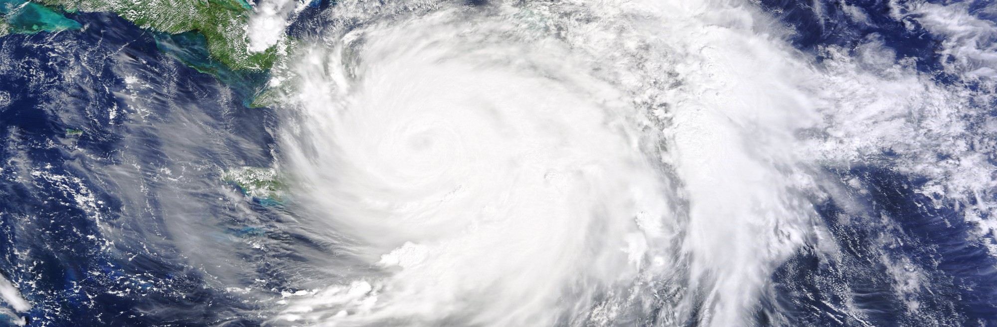
The hurricane laid waste multiple Caribbean Islands before pummeling Florida. Barbuda sustained such heavy damage that all of the island’s inhabitants had to temporarily evacuate to sister island Antigua ahead of Hurricane Jose, depopulating the island for the first time in centuries. Irma’s close brush with Puerto Rico severely weakened its infrastructure at the worst possible time, setting the stage for the U.S. commonwealth’s worst modern disaster.
Hurricane Maria made landfall as a strong category four and destroyed what Irma had weakened. Most Puerto Ricans remain without electricity or reliable access to basic necessities nearly two months after the storm. Maria left behind comparable damage on the small island of Dominica, which took the brunt of the category five hurricane at its strongest.
Many of these hurricanes broke one record after another. Harvey was the first major hurricane to hit the United States in 12 years, and it produced the most rain ever seen from one tropical cyclone in the United States. Irma was the strongest hurricane on record outside of the Caribbean or Gulf of Mexico, and it was one of the longest-lived category fives we’ve ever seen. Ophelia’s approach to Ireland was the farthest northeast we’ve ever recorded a major hurricane.
And yet, things could have been even worse. This season was a fantastic demonstration of how far weather forecasting has come over the decades. A season like this could have easily killed thousands of people not too long ago, without a network of satellites, radars, computer models, and experienced forecasters predicting the tracks of the storms with stunning accuracy. Forecasters also altered the way they issue warnings to help get the word out faster—a change directly influenced by Hurricane Sandy. A new weather satellite called GOES-16 helped us track the storms with unprecedented speed and clarity. The wonders of meteorology were on display this summer, and they helped save countless lives.
Some of these storm names will go down in infamy, never to be used again. The World Meteorological Organization, the meteorological arm of the United Nations, meets once a year to decide which hurricane names deserve retirement. Meteorologists retire the name of a particularly destructive or lethal hurricane to spare survivors the trauma of one day having to stare down another storm of the same name. We’re almost certainly never going to see storms named Harvey, Irma, or Maria ever again. When this year’s naming list is used again during the 2023 Atlantic hurricane season, these names will be replaced with new ones.
Even as we sigh a cautious breath of relief as winter’s grip takes hold, it never hurts to look ahead. Official forecasts for the 2018 Atlantic hurricane season won’t come out until next spring. But it’s possible to get a few clues by looking at the El Niño-Southern Oscillation (ENSO) cycle in the Pacific.
Current projections indicate that the abnormal warming or cooling of the Pacific, which can significantly affect the atmosphere over the tropical Atlantic Ocean, could be near neutral territory around the start of next year’s hurricane season. A neutral ENSO cycle—neither unusually warm nor cold—could portend a near-normal season. We’ll have a better idea in a few months of what could happen next summer, but it only takes one storm to make for a bad year.
