
A spring hike is a great way to take advantage of the newly-warm weather. But it also comes with hazards like lingering snow, unpredictable downpours, and winter-damaged roads and trails. To prepare, you need to bring basic essentials like extra clothing, snacks and water, and first aid supplies. In order to hit the trail with even more confidence, we also recommend that you carry technological help: Download some extra apps and pack a few trusty gadgets. We’ve selected 10 pieces of spring-hiking tech that will guide you through the great, still-slightly-damp outdoors.
1. AllTrails
When you’re deep in the woods, you can’t exactly rely on Google Maps. Instead, download AllTrails (free for Android and iOS), an app with 50,000 maps of trails all over the world.
Once you’ve chosen a route, AllTrails will plot your progress on a map, display upcoming terrain, and track statistics like steps, distance, and elevation. It will even save this information so you can see how far you’ve traveled in a single day or across your entire hiking career. The app also boasts user community of hikers who share photos, advice, and reviews to help you research interesting trails in advance. And it wraps up all this guidance in a sharp-looking interface that’s a pleasure to use.
The one downside to AllTrails is its reliance on a network connection—which can be pretty weak when you’re actually out in the woods. If you want to download maps for offline access, or print them out, you’ll need to pay for a Pro subscription, which costs $30 per year or a one-time fee of $100. The Pro account also includes the ability to create and save custom routes.
2. Amazon Tap

How tall is the mountain you’re climbing? What weather can you expect on your descent? If you rely on Alexa to answer questions like these, then bring the digital assistant with you on the Amazon Tap ($100 on Amazon), a portable version of the Echo smart speaker.
Alexa needs internet access, so the Tap will only work if you use a strong phone signal to set up internet tethering. Then the Tap will not only answer all your questions, but also connect to your device through Bluetooth. This will let you play podcasts or music, for up to nine hours, as you tramp along.
3. Cairn
Think of Cairn (free for iOS only) as a hiking safety net. If you don’t make it home on time, it will automatically ping a couple emergency contacts to let them know you’re still out in the wilderness.
In addition to potentially saving your life, Cairn plots your route as you go and provides helpful information for your hike: topographical charts of potential paths, crowdsourced maps showing where cell reception is patchy, and estimates of how long various trails will take.
Like AllTrails, Cairn will only give you offline access to this information if you purchase a premium subscription, which costs $5 per month or $27 per year. That will also buy you the option to send live updates to your emergency contacts.
4. Huntsman Pocket Knife
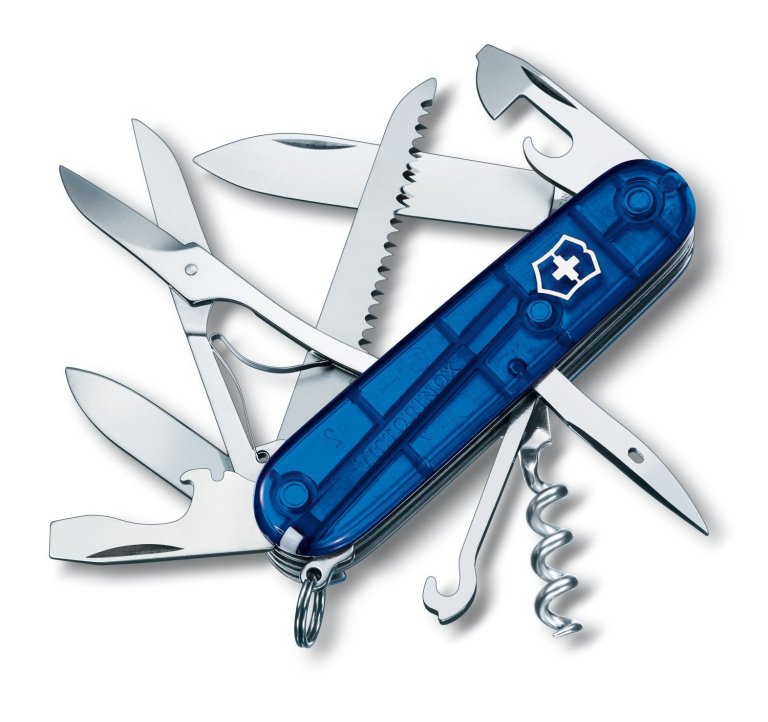
On the trail, a blade has all kinds of uses—and a multitool has even more. We like the Victorinox Swiss Army Huntsman Pocket Knife ($35 on Amazon), which strikes a nice balance between functionality, bulk, and price.
The tool’s 15 attachments can open bottles and cans, saw through wood, cut through paper, and perform other helpful tasks. It even has a pair of tweezers for removing that splinter that got stuck in your finger. When you’re ready to put the pocket knife away, its attachments fold into a package just 3.5 by 0.8 inches, weighing a measly 3.4 ounces. This makes it the perfect size for tucking in your pocket—so you can always be prepared.
5. Spyglass
Before the rise of smartphones, you used to need a compass to navigate. These days, you can simply download an app like Spyglass ($6 for Android and iOS, with a free trial available on Android). It contains a digital compass and a full GPS toolkit, with a few neat augmented-reality tricks that give it a fantastic-looking display.
Spyglass really is one of those must-have hiking apps. The compass updates as you move your phone and progress along your route, showing you the way you need to go for the next few steps. It can also display a zoomed-out map with waypoints that you aim for to keep your journey on track.
On top of that, you get bonus features like measuring your distance traveled, speed, and altitude. Want to channel the days when sailors steered with sextants? Spyglass will help you navigate using the stars. To really put the app through its paces, check out the app developer’s comprehensive user guide.
6. Garmin Fenix 5X Sapphire

For serious walkers—who also have a little (okay, a lot of) cash to spare—the Garmin Fenix 5X Sapphire ($620 on Amazon) is the smartwatch you need. Unlike some of the cheaper options on the market, it features solid on-board GPS. This can guide you to your destination even if your cell phone dies or you get stuck in a dead zone. And as you’d expect from the steep price, this watch is extremely well-built and capable of surviving the toughest weather.
Maps will pop up right on this watch. Like its competitors, it also lets you measure steps, distance traveled, and elevation, as well as other physical activities. And it can display notifications from your phone, allowing you to keep the larger screen in your backpack.
7. Peakfinder AR
If you prefer to spend your time on a slope, Peakfinder AR ($5 for Android and iOS) will tell you everything you could possibly want to know about the mountain ahead of you. With more than 350,000 mounts in its database, the app will help you get your bearings or simply learn more about the valley you’re traversing. It even works offline.
Just point your phone’s camera at a peak, and the app will display information through augmented reality. This data includes the names of all the peaks on a range, as well as their locations and heights. Then the app converts this augmented view into a line drawing for easier reference. Want to check out a mountain that’s just out of view? The app will let you “fly” over to peaks you can’t actually see.
8. Kedron Solar Charger
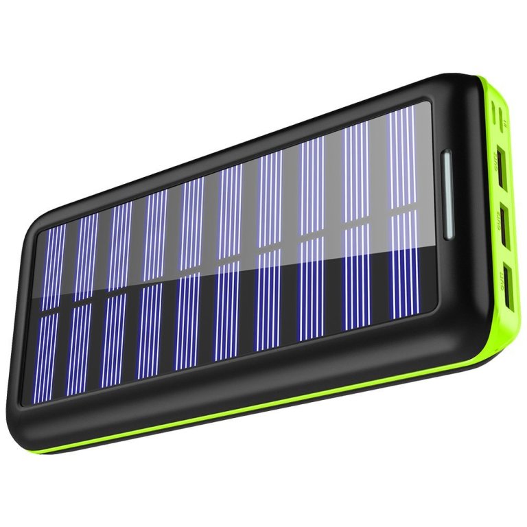
The Kedron Solar Charger ($40 on Amazon) will draw on sunlight to make sure your gadgets have enough juice. Even if the sky threatens to be overcast, you can charge it in advance before you head out.
Smartphone batteries drain quickly when you’re using the GPS, especially when you’re traveling through an area with a poor signal. The Kedron device will make sure your phone stays powered up through the end of the day. The charger’s 24,000mAh capacity will charge the average smartphone three or four times over. When you get home, built-in fast-charging technology will quickly restore its lost charge.
9. Map My Hike
Although other hiking apps offer to map your route, for a dedicated option, try Map My Hike (free for Android and iOS). It measures how far you’ve traveled and plots your route on a map so you can review your hike once you’re done. It also provides a detailed look at your progress, including steps, elevation gain, and average pace.
Map My Hike also includes a social side, letting you share walks and routes with friends. Add a premium subscription for $6 per month or $30 per year, and it will remove ads, and deliver you a personalized walking workout routine.
10. DJI Spark

To record your hike for posterity, bring a photo- and video-taking robot along with you. The DJI Spark drone ($550 on Amazon) will capture the scenery from above, and let you take the most dramatic of selfies.
Important for would-be hikers, the Spark weighs in at 1.5 pounds, so it won’t drag down your backpack too much. It’s also simple to operate, even for beginners—though do make sure you practice a bit before heading out.
As for its other specs, the Spark reaches a top speed of around 30 miles per hour and carries a 12 MP camera for those high-resolution snaps. It can only fly for 16 minutes between recharges, so if you plan to do a lot of filming, make sure to bring a spare battery.
