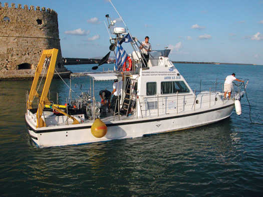
Early last October, Brendan Foley found himself on a small, inflatable boat making rings in the middle of the Aegean Sea. The 43-year-old maritime archaeologist was waiting on three divers, who were searching for ancient shipwrecks 100 feet below. Rather than drop anchor, the boat’s skipper, a potbellied Greek man named Giorgos, held the wheel hard to port, spinning the boat around and around. Whether inured to the repetitive course or just oblivious to it, Giorgos didn’t appear to mind making circles. But the repetition was making Foley antsy. He fidgeted with the zipper on his wetsuit. He rearranged the dive gear, still dripping wet from his own survey earlier that day. Then he sat down next to me and made an unusual confession for someone whose livelihood is tied to the sea. “I hate small boats,” he said. “Not too fond of big ones either.”
What Foley likes is finding shipwrecks, which is why he and his Greek colleagues chose the day’s dive site, Dia, a small, rocky island about eight miles north of Heraklion, the capital of Crete. The city has been an active port for about 6,000 years. In that time, it is likely that many Heraklion-bound ships wrecked on the cliffs of Dia. Jacques Cousteau found several wrecks on the island’s south shore in 1976 while searching for Atlantis. Foley and his team were the first archaeologists to search the north shore.
As much as Foley likes discovering shipwrecks—he’s found or helped find 26 in the past 14 years—he doesn’t much like spending time looking for them, at least not in the conventional ways. Rather than sending dive teams down to survey 1,000-foot transects one fin kick at a time, Foley prefers to use autonomous underwater vehicles (AUVs) to survey huge tracts of seafloor. Where the robots don’t work well, Foley sends down divers armed with closed-circuit rebreathers and thrusters, allowing them to cover more ground. He wants to go faster, he says, because he needs a lot more information. Maritime archaeologists can spend years on just a few sites, but for Foley’s purposes, a solitary wreck is statistically weak—nothing more than a few words from a greater conversation. To understand the entire conversation, maritime archaeologists must study many wrecks and identify patterns between them. Foley’s model is not the soft science of digging and interpretation, but the hard science of high-throughput screening deployed by gene and drug researchers, who gather data at an industrial rate and analyze that data with powerful computers able to detect subtle patterns beyond the reach of ordinary analysis.

If Foley can determine where hundreds or even thousands of ancient ships were headed, when they were headed there, and what they were carrying, he could use computer analysis to trace the origin of the world’s earliest cultures, and in so doing he could test his central hypothesis: that it was seaborne trade that enabled the spread of civilization in the Mediterranean Basin. But to do all of that on a computer, he first wants to “map, in exquisite detail, the entire seafloor of the Mediterranean,” a sea that covers nearly a million square miles and may contain as many as 300,000 wrecks.
Today is proving to be especially difficult. Foley’s AUVs wouldn’t work near Dia; its steep undersea cliffs interfere with the robots’ sensors. Someone also left a critical part of the thrusters back at the dock in Heraklion. Instead of finding wrecks fast, Foley’s team was left to search out wrecks the old-fashioned way. He and his dive partner had made one dive earlier and had come up with nothing.
After a few more minutes spent motoring in circles, Foley took action. Earlier in the morning, Giorgos mentioned how much he’d enjoy diving in the area, so Foley, in his typical collegial manner, suggested that it was a good time for him to do just that, and added: “Mind if I drive?” Taking the helm, Foley backed the engine down to an idle. The boat slowed, bobbing over mild swells bearing south toward Dia’s yellow cliffs. The temperature was about 80 degrees and the visibility underwater about 100 feet. Now at least in control of something, Foley looked comfortable, happy even.
Given a choice, though, Foley would not be on a small boat on a perfect day. He wouldn’t even be on a large boat. Instead he would be seated on his tiled patio in Heraklion poring over the latest data collected by his robots.

Maritime archaeology is just the latest beneficiary of high-throughput techniques, a revolution in data collection and analysis that began decades ago in computer science and manufacturing. The approach made its best-known inroads to science in the Human Genome Project, a government program started in 1990. In 13 years, researchers would sequence the 3.3 billion chemical base pairs and 25,000 genes that make up human DNA. The basis of high-throughput screening is automation. Robots gather hundreds, thousands or even millions of data points systematically and feed them into large computers where they’re analyzed for patterns. In the case of the Human Genome Project, high throughput allowed scientists to automate the sequencing of the base pairs of a piece of DNA.
As robotic systems and processing power have advanced, high-throughput screening has become faster and more reliable. And scientists outside molecular biology have started to apply these methods to their fields. Pharmacologists, for example, use them to discover potential new drugs by screening hundreds of compounds simultaneously for biological activity, and neuroscientists at the Human Connectome Project are mapping many of the 100 billion neurons in healthy brains. The work could reveal how the brain connects as a whole or where damaged brains are miswired.
Until recently, maritime archaeology was an unlikely candidate for high-throughput techniques. Automated systems appropriate for the field did not exist, and the notion of gathering large data sets runs counter to standard archaeological practice for shipwrecks. Rather than taking cursory surveys of many sites, most archaeologists prefer to linger at one or a handful of sites for years. Because archaeology so often relies more on interpretation than quantifiable data, it is often lumped in with other soft sciences, such as history and cultural anthropology.
Foley is trying to make maritime archaeology a hard science, more in league with biology or physics. He says he doesn’t care about painstakingly examining every last shipwreck. Rather, he plans to automate the discovery of hundreds or thousands of shipwrecks, transform them into a large data set, and probe that data set—not the wrecks themselves—for answers to his questions.
Most ancient wrecks in the Mediterranean are little more than piles of amphorae, two-handled urns that were used as shipping containers. But scientists have developed methods to draw information from them. By examining the size of the pile (once the boat, which has long since rotted away) and the shape of the amphorae, archaeologists can often place the wreck’s origin and its era. The wreck’s location gives hints to its destination.
More often than not, archaeologists date wrecks in the Mediterranean to the Roman or Byzantine era, when sea trade was already well-established. Although these are useful data points to Foley, he is particularly focused on finding Bronze Age wrecks, which date from 3500 to 1200 B.C. They were the first seafaring ships in the region, so their locations and contents could indicate which cultures were in contact with each other at the time. But they are exceedingly rare.
“Foley is trying to make maritime archaeology a hard science, more in league with biology or physics.”Foley’s data-driven approach to maritime archaeology is not entirely new. For example, in 1992 archaeologist A.J. Parker cataloged all the 1,259 known shipwrecks in the Mediterranean. But that data is rudimentary, Foley says, and the inconsistencies in how it was collected make it difficult to compare one ship with the next (some wrecks are well-known excavations; others were found by chance by sponge divers and, unlike wrecks excavated by specialists, may not have been properly categorized by age or origin). Foley’s robots will collect uniform data so that archaeologists can directly compare one wreck with another.
When describing his work, Foley can make high-throughput archaeology sound simple, as if it’s just a matter of time before all the wrecks in the Mediterranean are charted, digitized, and stored. It’s not. Foley’s approach is unproven, technically challenging and expensive. His month-long expedition to Crete cost about $500,000—his entire annual budget—a sum most archaeologists would spread across half a decade. To pay for his robots and the staff necessary to run them, Foley, like most ocean scientists, applies for grants from the National Science Foundation and the National Oceanic and Atmospheric Administration. But the bulk of his funds come from other sources, mostly private donors. When not hunting wrecks, Foley is courting potential benefactors. He attended dozens of fund-raising events last year alone.
Foley’s emphasis on private fundraising is unusual for most scientists, but he goes about it unabashedly. In fact, he is pressing to increase his annual budget fivefold, to $2.5 million. “Why is it that physicists can have a multibillion-dollar facility like CERN and archaeologists don’t?” he says when I ask him about the high price tag. “Do you really care what a muon is? Does anybody really care what a muon is, besides physicists? I argue that it’s just as important, maybe even more important, to understand what it is to be human.”

A few days after the excursion to Dia, Greg Packard gave me an impromptu demonstration in robot handling in the waters off Heraklion. Packard, a wiry engineering technician from the Woods Hole Oceanographic Institution in Massachusetts, was balanced at the stern of the research ship Alkyon and jabbing a pole at a five-foot-long yellow torpedo floating just out of reach. The torpedo was actually a Remus 100, a $375,000 autonomous robot on loan from Woods Hole, equipped with a video camera. A third of the way into its 80-minute survey, the robot had sprung a leak. It automatically aborted the mission and returned to the boat. With the pole, Packard was trying to hook a loop on top of the robot so he could pull it toward the Alkyon’s winch and bring it on board.
After much jabbing and winching and some help from another technician, Packard got the 80-pound craft onto the Alkyon’s deck and into a scarred expedition case. Then he and some of his Greek colleagues launched a second Remus, this one outfitted with sonar, off the stern. The robot swam on the surface for a few moments while Packard tested its tracking system from a ruggedized laptop, and then it dove out of sight and headed to an unexplored section of seafloor.
Foley’s data-gathering system is built around these two Remus robots. The sonar-equipped “acoustic” Remus scans the seafloor first. It travels at up to 328 feet below the water’s surface in a grid pattern while its transducers send a sonar beam across the seafloor. Those signals reflect off solid objects, including large fish, rocks and shipwrecks, producing highlights and shadows in the resultant images. On this trip, the acoustic Remus was complemented by a multibeam sonar built onto the Alkyon’s hull. With it, the team scanned large swaths of the seafloor, albeit at a lower resolution than the acoustic Remus provides.
If Packard finds a shadow in the sonar data that might indicate a shipwreck, he sends out the video-camera-equipped Remus. Sonar images can be difficult to read, so potential wrecks must be examined with video. Once a wreck is confirmed, a dive team descends to the site and snaps hundreds of photos. Later, a graduate student will digitally stitch these photos together and tag the “photomosaic” with location and depth data.
Onshore, having robots gather and computers analyze your data sounds like a great idea, but in the field the challenges are many. First, the Mediterranean is huge. At the rate he’s going right now, Foley would need 2,658 years to map the entire seafloor. Second, many areas of the Mediterranean seafloor are dynamic, with shifting sands that cover anything that may be down there. Third, the robots’ sensors can’t operate very close to islands and coasts that have steep slopes near the seafloor, just the place where many wrecks happen. These regions require dive teams, slowing the rate of discovery. The gear that speeds up the diving is expensive. Each thruster costs $3,500 and each rebreather $15,000; Foley brought four thrusters and six rebreathers on his trip.
If Foley manages to overcome those challenges and collect his data, he will then face yet another obstacle: how to analyze it. He hasn’t yet defined his approach. When I asked him, he said data analysis is a problem he chooses to “kick down the road.” He did say that one possibility would be to create image-recognition software that could identify boat size and amphora shape, categorizing the wrecks by era and origin, and correlate that with the location data and potential destinations. In this way he could, for example, identify all Bronze Age wrecks in the southern Aegean. If the set was large enough, patterns in the data might suggest questions that Foley hadn’t even thought to ask.
As Packard and I sat on the Alkyon waiting for the acoustic Remus to finish its survey, a fishing trawler appeared a few miles off the bow. Packard emerged from the cabin where he’d been monitoring the Remus from his laptop and eyed the trawler. He frowned and stepped back into the cabin, where he typed out a few commands to reprogram the Remus to safer waters so the fishermen wouldn’t net it along with their quarry.
For a field to shift from interpretive to data-driven is not unprecedented, says Theodore Porter, a historian at the University of California at Los Angeles who specializes in the quantification of science. Geography, Porter says, is an example of a field that has become strongly quantitative and data-driven. In the past five decades, drafting techniques and static cartography have merged with geographic information systems, which pull data from numerous sources to create digital, interactive maps. Economics has also morphed from an interpretive science into one driven by mathematics (though how successful this transition was depends on who you ask).
Archaeologists have been moving toward more quantitative approaches for decades, says Michael McCormick, a Harvard University archaeologist and historian. They already use techniques such as radio-carbon dating and DNA analysis to transform physical objects into data. Foley’s method is a next step.
After that step is taken, it would create a self-perpetuating data feedback loop. With more data comes more options. Archaeologists won’t need to physically visit each wreck to determine if it’s worth exploring. The ability to target only significant wrecks will yield more-productive excavations, which in turn will yield more data to analyze and cross-reference and from which patterns may emerge to further describe the ancient world.
High-throughput archaeology will not supplant older techniques, such as excavation. Rather, McCormick says, the methods are complementary. “One shipwreck that is exquisitely excavated and published is a fantastic time capsule from the time and place where it went down, the places it was sailing to and from,” he says. “But 100 shipwrecks, even if we know only a little bit about each of them, give us a whole different type of evidence that we can compare with the exquisite, unique and rare fully excavated shipwrecks. And they will illuminate each other.”

Two weeks after the Greek expedition, I called Foley to see how things had gone following my departure. He was in the middle of readying a presentation for the trustees of the American School of Classical Studies at Athens. “We had a pretty good showing,” he said. In a month, the team found eight wrecks. Granted, three of those were modern, and of the five ancient wrecks, one of them, a Roman ship, was previously known from Cousteau’s work on Dia. Neither divers nor robots had found a Bronze Age wreck.
Nonetheless, Foley said he was not discouraged. Four new ancient wrecks plus the Cousteau wreck were five more data points to add to his database. He said that his donors knew that finding a Bronze Age ship was a long shot. And he said he’s encouraged that the acoustic Remus found a ship—proof, he said, that his system will work.
Even before leaving Crete, Foley had a few expeditions in mind for the following year. This spring, he may survey the waters off Algeria for the first time. His Algerian colleagues will use ship-based sonar to look for underwater seismic faults; Foley is counting on that sonar to find a few shipwrecks in the process. He’s also working to establish new contacts in Egypt and Libya, because the ones he negotiated with last year were ousted in the Arab Spring.
Foley said he also plans to expand his robot fleet, adding larger AUVs like the Remus 6000, which can dive to 19,685 feet. The additional robots will allow him to explore a lot of new terrain, possibly even the deepest zones of the Mediterranean.
“100 shipwrecks, even if we know only a little bit about them, give us a whole different type of evidence.”After his expedition to Crete, Foley had 34 ancient wrecks, some of them found by conventional means, while his divers and AUVs found others in his database. Though that is a very long way from 300,000, it’s not a reason to dismiss his work. As much as he would like to, Foley does not actually need to catalog all 300,000 wrecks. He’ll need only a few hundred or maybe a few thousand to achieve statistical significance across a range of queries. With more robots and more funds, he could do it. And even if he doesn’t—even if Foley just goes along adding a handful of wrecks a year to his database—he plans to continue his work for the next 25 years or so. “I don’t go poking my head into other people’s labs to ask if what they’re doing is worth doing,” he says. “If you can generate funding and go out and do your projects and publish your papers, what more validation do you need?”

FINDING SHIPWRECKS FASTER
1. The acoustic Remus 100 AUV scans, for example, a one-square-mile patch of seafloor with sonar, a process that requires about 4.5 hours. The sonar bounces off large objects to create highlights and shadows that reveal the rough outlines of a wreck.
2. If the sonar images indicate a shipwreck, the video Remus goes in for a targeted scan of the area. The video Remus cannot take high-quality images, so any shipwrecks confirmed by the visual data are later photographed by a team of divers.
3. Underwater cliffs interfere with sonar signals, so in areas where the seafloor is near one, Foley’s team searches for wrecks by diving. Divers equipped with rebreathers can stay down about three times as long as one with scuba gear. Thrusters allow them to cover twice the ground that divers swimming under their own power can survey.

Portrait of a Shipwreck

Ancient wrecks, such as this one from the 4th century B.C., are mostly just debris fields of amphorae, but they can still contain a great deal of data. Once a wreck is identified, divers take hundreds of photos of the site with Nikon D100 and D300 cameras. Those photos are stitched together into a photomosaic [above], which is then tagged with information on the location and depth of the wreck.
Brooke Borel is a contributing editor at Popular Science. She lives in Brooklyn.
