

Here we go, folks. Hurricane/snowstorm/apocalyptic omen Sandy is churning up the East Coast and preparing to make what is sure to be calamitous landfall in southern New Jersey sometime later today. The so-called “frankenstorm” (a name that will likely end up next to “snowmageddon” in the dustbin of terms we never want to see in a headline again) is threatening some of America’s most densely populated areas including New York City, where PopSci staffers have fanned out across the five boroughs to report on the chaos–mostly because we can’t leave our apartments. We’ll be posting updates and images from the storm here, so stay tuned.
4:34 p.m.: Flood inspections still ongoing in New York. Howard Glaser, Director of Operations for the state, is tweeting shots of the damage.
3:38 p.m.: New Jersey’s Oyster Creek nuclear power plant is still under an “alert,” and the Washington Post is reporting that Sandy also shut down three nuclear power reactors–in Scriba, New York; Buchanan, New York; and Hancocks Bridge, New Jersey.
3:18 p.m.: 8.5 million homes are without power. That represents 7 percent of the U.S. population.
3:07 p.m.: More than 2 million people in New York are without power now.
2:44 p.m.: Scene from New York, tweeted by @ohnorosco : “Didn’t get AT&T service until I walked to 27th. Didn’t see power until 39th. This the scene 39th–63rd at every ATM”

2:31 p.m.: An updated number puts the death toll at 38.
1:57 p.m.: Just tweeted by JetBlue: this photo of LaGuargia Airport with a flooded tarmac.
1:26 p.m.: U.S. death toll now at 35 people across seven states, the New York Daily News reports.
1:15 p.m.: More than 16,000 flights have been canceled and eight major airports shut down by Sandy.
1:10 p.m.: Another (better) photo of a boat that wound up on a New York transit line.

12:58 p.m.: U.S. stock markets will reopen tomorrow after being closed today and yesterday, per @NBCNews.
12:38 p.m.: Another photo of cars submerged, from Davey Davis via @BBCBreaking

12:17 p.m.: Latest figure from CNN: 94 people have been killed by Sandy, and 26 of those are in the U.S.
12:08 p.m.: Maybe take this with a generous amount of salt since it’s still so early, but experts are saying Sandy could cost the U.S. $10 billion a day.
11:47 a.m.: Google’s Crisis Response team has put out this interactive map with a ton of information on flooding zones, power outages, and more.
11:26 a.m.: 10 confirmed dead in New York. Water is safe to drink, Bloomberg says. Roads, if not open yet, will be soon.
11:17 a.m.: Speaking of New York transit: Mayor Bloomberg says, optimistically, three to four days until subway returns.
11:14 a.m.: This boat was washed right onto the tracks at Metro-North’s Ossining Station in New York.

11:09 a.m.: New York City Mayor Michael Bloomberg: storm “may be the worst that we have ever experienced.” Shelters will remain open. Fixing mass transit grid is going to take some time. “No firm timeline” for fixing public transport, but buses may return tomorrow. All major airports closed–no flights leaving or arriving. No storm-related fatalities at any hospitals.
11:01 a.m.: There are now 16 confirmed deaths across the U.S.
10:59 a.m.: With morning here, more and more photos keep popping up. This one shows flooding in New York’s East Village.

10:41 a.m.: Another insane photo. This one of a tree in front of a home in Weehawken, New Jersey. (From Jason Del Rey.)

10:15 a.m.: There are some (still-early) approximations about the damage caused by Sandy.
- More than 6 million are without power in at least 17 states, according to the New York Times.
- About 250,000 of those were in lower Manhattan.
- At least 10 people were killed, across multiple states and Canada.
- New Jersey’s Oyster Creek power plant was placed on alert.
- Also in New Jersey, the Hoboken PATH station was hit with massive flooding.

- Both the main and backup energy generators were knocked out at New York University Medical Center, forcing teams to move about 215 patients.
10:07 a.m.: Here’s a timelapse video of Sandy moving inland from 6 a.m. to 6:30 p.m. yesterday, created by NASA Earth Observatory.

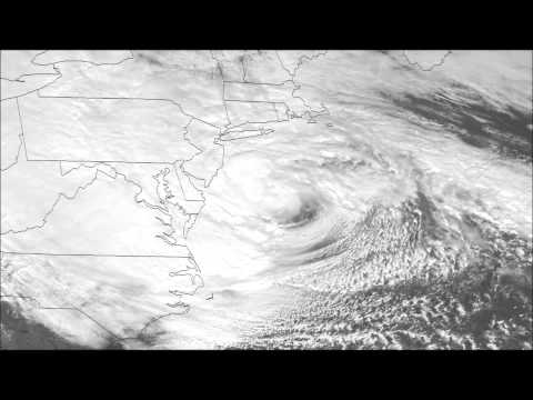
9:55 a.m.: The latest image from NOAA/NASA GOES Project shows Hurricane Sandy rolling inland this morning, weakened, but still pretty damned huge.

October 30, 9:50 a.m.: After some much needed rest–and perhaps a beer or two–PopSci.com’s storm team is back up! Check back throughout the day for live updates.
October 29, 10:40 p.m.: PopSci.com’s storm team is calling it a night. Check back tomorrow for more coverage!
10:30 p.m.: More than 2.8 million people across the Northeast have lost powerCNN says.
10:15 p.m.: CNN puts the storm’s U.S. death toll at nine.
10:00 p.m.: More insane footage, this one apparently captures a transformer exploding in New York City (fast-forward about 20 seconds).

9:50 p.m.:Check out this pic of flooding at a Ground Zero construction site:

9:40 p.m.: Dramatic video of the facade of Manhattan building being ripped off (skip to about 45 seconds in):

9:12 p.m.:Up to 4 feet of seawater flooding NYC subway tunnels, the Metropolitan Transportation Authority reports.
9:09 p.m.: Five people confirmed dead in New York state, the Weather Channel reports.
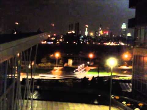
8:45 p.m.: Con Edison has shut off power to parts of Manhattan. Pretty creepy-looking.

8:20 p.m.:The New York Times is reporting NYC’s first storm-related fatality, a 30-year-old Queens man, who died after a tree struck his home.
8:06 p.m.: Forecasters say the center of the hurricane has made landfall in New Jersey, the Associated Press reports.
7:54 p.m.: Associated Press reports first fatality from the storm, per @twc_hurricane
7:46 p.m.: Gawker and its sister sites (Gizmodo, Kotaku, and others) as well as Buzzfeed have both crashed, apparently from problems with data centers in the New York area.
7:30 p.m.: The facade has been ripped off a building at Eighth avenue and 15th street in Chelsea, New York. Early reports say no one was injured.

7:08 p.m.: Sandy loses “hurricane” status, now designated a post-tropical cyclone, according toNOAA. Max winds have decreased slightly to about 85 MPH.
6:30 p.m.: More than 1 million people now without power, CBS News reports. And the hurricane hasn’t even made landfall yet.
6:20 p.m.: Via our friends at Deadspin: Bob Vila is answering your most pressing hurricane questions live.
5:40 p.m.: Landfall is expected in south Jersey or along the Delmarva peninsula by 7 p.m.
5 p.m.: Hurricane Sandy moving quickly toward southern New Jersey and Delaware, NOAA reports.
2:53 p.m.: An animated gif from NOAA shows the progression of Sandy as it picks up steam heading to the northeast. (above)
2:33 p.m.: Maybe inevitably, this storm is getting compared to 2011’s Hurricane Irene. But as the Wall Street Journal shows in a simple, interactive graphic, there’s not really even a comparison.
HURRICANE IRENE

HURRICANE SANDY

2:05 p.m.: We’re still not at the peak of the storm yet, but we’re seeing flooding photos coming in. Here’s one from south of Long Beach Island in New Jersey. Meanwhile, the stock markets will stay closed tomorrow. This is the first time its happened due to weather since 1985.

1:40 p.m.: Here’s a look at Sandy as viewed by the International Space Station. It’s 260 miles above the Atlantic Ocean as the winds move at 90 mph. (**Updated for clarification: Hurricane winds are moving 90 mph, not the ISS.)
1:15 p.m.: Power outages have affected more than 67,000 customers in New York, Connecticut, Virginia, Rhode Island, Delaware, New Jersey, Maryland, Pennsylvania, North Carolina, and Massachusetts.
12:50 p.m.: President Obama makes a statement. Says everyone should anticipate a lot of power outages, and a lot of time until those outages get fixed.
12:34 p.m.: There are some reports that a fishing pier in Maryland was destroyed at high tide ahead of the storm.
12:08 p.m.: Hurricane Sandy is now the largest tropical storm ever recorded in the Atlantic, according to Bloomberg Businessweek.
11:57 a.m.: A new statement on the storm is out from the National Hurricane Center. Here’s part of the 48-hour report, saying winds are increasing:
REPORTS FROM AN AIR FORCE HURRICANE HUNTER AIRCRAFT INDICATE THAT THE MAXIMUM SUSTAINED WINDS HAVE INCREASED TO NEAR 90 MPH…150 KM/H…WITH HIGHER GUSTS. SANDY IS EXPECTED TO TRANSITION INTO A FRONTAL OR WINTERTIME LOW PRESSURE SYSTEM PRIOR TO LANDFALL. HOWEVER…THIS TRANSITION WILL NOT BE ACCOMPANIED BY A WEAKENING OF THE SYSTEM…AND…IN FACT…A LITTLE STRENGTHENING IS POSSIBLE DURING THIS PROCESS. SANDY IS EXPECTED TO WEAKEN AFTER MOVING INLAND.
HURRICANE-FORCE WINDS EXTEND OUTWARD UP TO 175 MILES…280 KM…MAINLY SOUTHWEST OF THE CENTER…AND TROPICAL-STORM-FORCE WINDS EXTEND OUTWARD UP TO 485 MILES…780 KM. SUSTAINED WINDS TO TROPICAL STORM FORCE ARE OCCURRING FROM LONG ISLAND SOUTHWARD ALONG THE COASTS OF NEW JERSEY…DELAWARE…AND EASTERN VIRGINIA…AND EXTEND AS FAR INLAND AS THE CENTRAL AND SOUTHERN CHESAPEAKE BAY AND DELAWARE BAY. A WEATHERFLOW REPORT INDICATES A SUSTAINED WIND OF 53 MPH…85 KM/H…WITH A GUST TO 63 MPH…102 KM/H…HAS RECENTLY OCCURRED ON LONG ISLAND AT EATONS NECK NEW YORK.
11:45 a.m.: Weather Underground has a great, clear post on exactly what to expect. Even better, it’s organized by state in a readable format. See it here.
11:27 a.m.: Parts of New York are starting to flood. Via Instacane, we’re getting a look at some shots of it. Here’s Hoboken Terminal in north New Jersey:

And here’s one near the Hudson River:

11:02 a.m.: This is a 3-D model of Sandy created using data from NASA’s Tropical Rainfall Measuring Mission satellite. One thing to glean from this view: Even though it’s just barely a Category 1 hurricane, the model shows it has some properties (like a strong, compact wall around the eye) that don’t usually appear until Category 3 hurricanes.

10:48 a.m.: NOAA is tracking Sandy roughly 200 miles southeast of Atlantic City (that’s about 260 miles south-southeast of New York City) moving 20 miles per hour to the north-northwest, showing maximum sustained winds at 90 miles an hour as the storm prepares to turn further northwestward (read: inland) over the next few hours.
