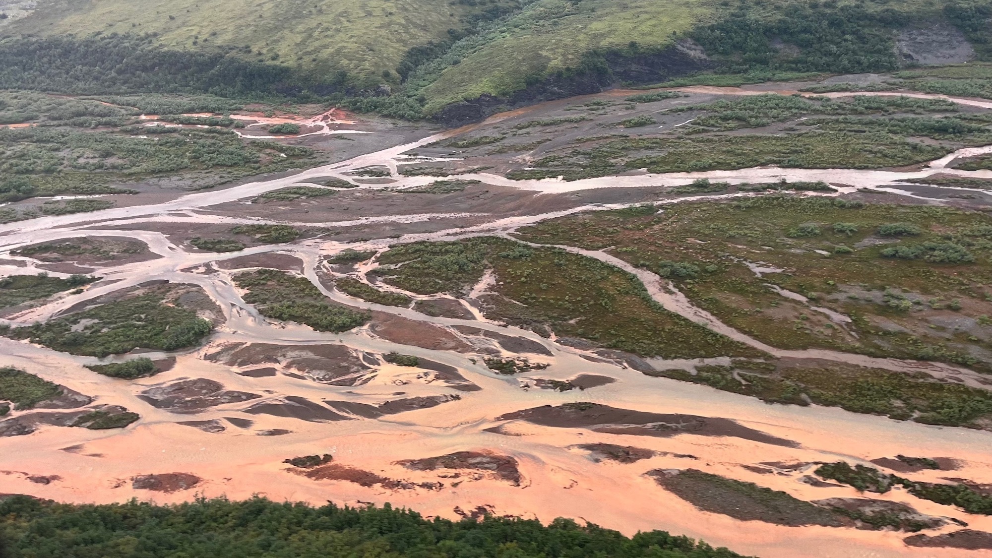
Alaska’s Arctic rivers have a big, orange problem. Previously clear rivers are turning a cloudy orange color due to iron particles, and it’s more than unsightly. The particles can suffocate fish and choke insects, threatening the food web and ecosystem as a whole.
Scientists have long pointed to previously frozen soil beginning to thaw as the potential culprit behind the contamination of rivers in northern Alaska’s remote Brooks Range, and a study recently published in the Communications Earth & Environment proves it. The research also shows two distinct ways that this thawing soil is rusting the rivers and can help scientists predict where the damage is likely to spread next.
“You’d think if any ecosystem could hide from the effects of warming and big human footprints, it’d be this one. But it’s not so,” Tim Lyons, a study co-author and biogeochemist at the University of California, Riverside, said in a statement. “There is no safe place.”
From thawing permafrost to orange water
Permafrost is rock or soil that contains ice that has been frozen for two or more years. Alaska is warming two to three times faster than the global average, melting some of the permafrost that has been frozen for thousands of years. That thawing permafrost is already threatening the Tracy Arm Fjord, a popular destination for Alaskan cruises.
As the ice-filled permafrost begins to thaw due to climate change, it can turn into mud that can’t support the weight of the soil or vegetation above it. This can threaten human-built infrastructure such as homes, pipes, and roads. It can also expose iron particles from rocks that turn rivers orange, a process called rusting.
Rusting has severe ecological consequences. The fine iron particles can stay suspended in water for over 60 miles, smothering algae, disrupting insect populations, and clogging fish gills. These changes may already be affecting salmon in Alaska and Canada who rely on the gravel riverbeds for spawning and rely on algae as food during early life stages.
A top-down, fool’s gold problem
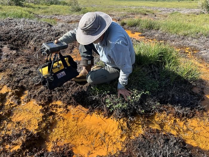
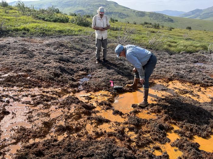
For this new study, the team looked at a wide regional view of the roughly 600-mile Brooks Range. They then zoomed in on a specific river system, followed by an even closer look at one creek. This top-down approach helped them to connect the bigger regional patterns to specific, on-the-ground processes.
“At middle, more heavily forested elevations, there isn’t much going on. But at the higher and lower elevations we could see distinctly different phenomena,” said Roman Dial, a study co-author math and biology professor emeritus at Alaska Pacific University.
At the higher elevations, the problem begins in the rocky ground containing pyrite, aka fool’s gold. Since the ground was frozen for many years, water and air didn’t affect the pyrite. Yet the rising temperatures have started to melt the ground, kicking off a process called acid rock drainage. The minerals and rocks are exposed to oxygen and water and degrade the water quality.
“When pyrite meets water, it comes apart. It breaks down into iron and sulfur, creating sulfuric acid as well as sulfate and other toxic metals,” said Lyons. “When the iron-rich water mixes with more oxygen, the iron turns into rust-like particles that color the water and stain the bottom sediments orange.”
It’s an entirely different story at the lower elevations. The landscape is covered with wetlands that are changing shape and expanding downward as the permafrost melts. In these more soggy places, the soils are low in oxygen. So instead of breathing in oxygen, the microbes in the water (mostly bacteria) are taking in iron.
“When we breathe, oxygen goes in and gets converted to the carbon dioxide that we exhale,” Dial said. “Similarly, microbes are consuming iron in the lowland soils and converting it into a water-soluble form that seeps into streams and results in rusting as it meets oxygenated surface water.”
Taken together, both acid rock drainage and microbes breathing in more iron help explain why orange waters are appearing across such large and remote regions across northern Alaska, closely tracking to areas where permafrost is thawing.
The direct link
The team also found a delayed effect that could help predict future contamination. During the summer, the active, top layer of soil thaws to its deepest point. It then refreezes before the winter. The iron released during one summer thaw can become trapped and then flushed into rivers the following year.
By studying long-term ground temperature data and stream chemistry, this lag can be used to anticipate increases in metal levels.
“That means we can use ground temperatures to help predict water quality in the future,” added study co-author and University of Alaska ecologist Paddy Sullivan. In 2019, Sullivan first noticed the dramatic river changes that looked “like sewage” during fieldwork in the region.
Since mines typically control the waters near them to minimize pollution, the team partnered with scientists at the Red Dog zinc mine in northwest Alaska. The scientists there have long-term temperature records from boreholes that are drilled deeply into the earth and from chemistry sampling in stream water. Linking the underground measurements with changes in the stream’s chemistry directly connected the thawing permafrost to the rusting rivers.
While this problem is difficult to contain and manage, predicting where the contamination may pop up next could help pinpoint and protect critical habitats. This forecasting is especially important for communities that depend on these waters and the fishing living there for food and cultural practices.
“There’s no fixing this once it starts,” Lyons said. “But we can give people downstream a heads up and work hard to protect the places that are still safe and less vulnerable to the rusting.”
