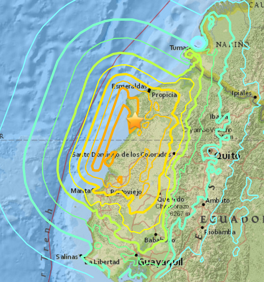
An earthquake with a magnitude of 7.8 struck Ecuador late last night, just 105 miles to the north west of the capital of Quito. Aftershocks are still shuddering through the area.
The large earthquake in Ecuador comes days after a series of large earthquakes struck the Japanese island of Kyushu. There is no known connection between the earthquakes in Japan and Ecuador.
While there may be no direct link between the events across the Pacific, the close timing of the disasters leaves a vast number of people in both hemispheres struggling and shaken to their core. In addition to caring for the injured and bereaved, and tending to the dead, both countries must face the prospect of rebuilding and restoring basic services like electricity and water. Japan must contend with an estimated 250,000 people left homeless while in Ecuador, the toll is still-uncounted.
At the time of this writing, the estimates for the death toll in Ecuador are still uncertain, but at least 77 have died. The United States Geological Survey (USGS) is currently estimating a 34 percent chance the death toll will remain between 100 and 1000. There is a slightly smaller (30 percent) chance that the death toll will be higher, between 1,000 and 10,000.
Like Japan, Ecuador is used to earthquakes. It lies on the boundary of the Nazca and South American tectonic plates. Tectonic plates are sections of the Earth’s crust that move over a semi-molten mantle deeper inside the Earth. In this case, the Nazca plate lies under the section of the Pacific Ocean just west of South America. At the intersection of the two plates, called a plate boundary, the seafloor of the Nazca is pushing under South America at a rate of about 2.5 inches a year.
That might not seem like much, but it’s enough to build the Andes mountains over the course of well over 100 million years. And the plates don’t always slide sedately under each other. Sometimes, they slip. Earthquakes move the process along considerably faster than normal, jerking over longer distances in a much shorter time. The jerking movement of a sliding plate causes a release of energy, some of which shudders through the crust, creating an earthquake.
Instead of originating at a single point, this earthquake was likely caused by a rupture along the plate boundary that stretched over a 99 mile long by 37 mile wide area, roughly 12 miles under the Earth’s surface.
This area in particular has a history of truly massive events. The USGS notes that seven earthquakes larger than a magnitude seven have occurred within 150 miles of this event since 1900. The area that ruptured on Saturday night is just the southern section of a part of the plate boundary, which has slipped before with catastrophic results. Back in 1906, a 250-310 miles-long part of the fault ruptured just like it did last night, only with even more force, hitting a magnitude 8.3 and causing a tsunami that killed hundreds of people.
8.3 might not seem to be much larger than a 7.8 numerically, but magnitude is actually a logarithmic scale measuring the amount of energy released by an earthquake at the source. The 8.3 magnitude earthquake 110 years ago released a whopping 5.6 times more energy than the 7.8 earthquake that struck last night.
And last night’s earthquake was no slouch. The energy released during the 7.8 magnitude quake was the equal to the energy of 9,778,740.5 of the atomic bombs dropped on Hiroshima, or enough energy to power the entire United States for six years.
