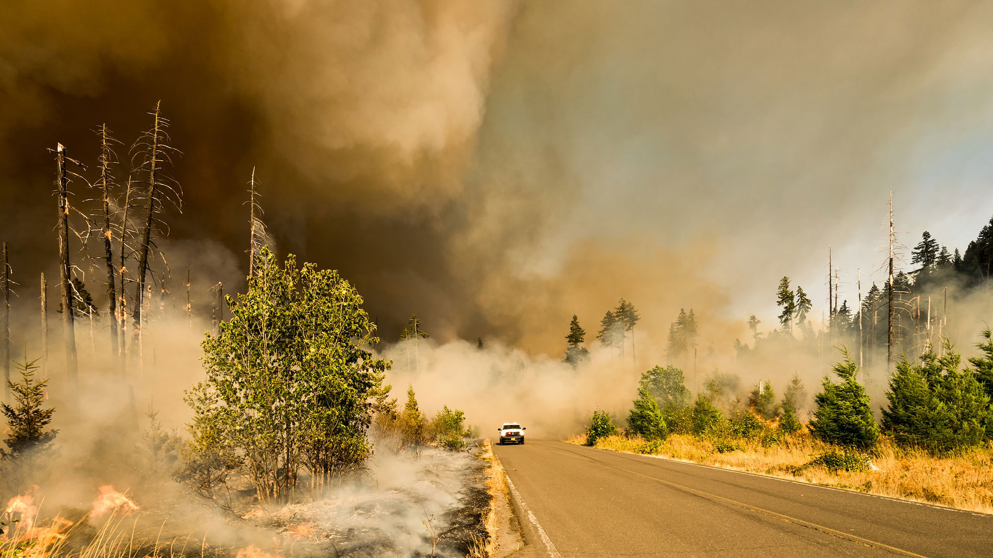
On a late summer day last year, an emergency test alert popped up for a small number of pre-selected drivers in Fairfax County, Virginia, warning of a fictitious brushfire in their area. But this message didn’t just come through a beep or buzz on their phones—it was also shared directly on the infotainment consoles in their cars, with a “fire zone” area appearing on their on-screen maps.
These test messages were for a live demonstration of a years-in-the-making project to update emergency alerts for wildfires. While wireless emergency alerts have been available on cell phones for more than a decade, there is currently no method for sending them directly to car screens. The hope for this new system is that having an alert display in vehicles could help authorities reach people who live in areas at risk of wildfires—people who are otherwise challenging to notify through other warning methods.
In particular, this pilot project is focused on the “wildland-urban interface,” or WUI. According to the Federal Emergency Management Agency (FEMA), WUI areas are any neighborhoods or residential settlements at the cusp of, or even mixed in with, undeveloped land. Across the United States, more than 46 million homes are at a heightened risk of wildfires due to their location in the WUI.
When a wildfire does occur in these areas, it can be particularly difficult to notify residents. Oftentimes, homes in WUI regions are spread out, making methods like sirens or door-knocking less viable. These areas also tend to have limited reception and internet connectivity, which can mean residents do not receive cell phone alerts. And even if the alerts do come through, they typically do not include direction information to get to safety. In recent years, multiple WUI communities have reported a lack in sufficient wildfire warnings, including those impacted by the 2018 Camp Fire in California and the 2021 Marshall Fire in Colorado. In some cases, community members in such areas have even developed their own apps and outlets in an effort to address this gap.
It was after learning about residents’ frustrations following the Marshall Fire that Norman Speicher says his office began to explore other alerting options. Speicher works at the Department of Homeland Security as a program manager for the Science and Technology Directorate (S&T), which is the research and development branch of DHS. His team wanted to find new ways to “bring the information to where people already are,” Speicher says, and became interested in the idea of sending messages straight to car infotainment systems, which are the built-in screens that can display your connected phone, GPS services, and other information about your vehicle.
The Virginia test in August 2022 was the first (almost) real-world trial of that idea, which the S&T is calling the WUI Integration Model. While it’s still deep in development, Speicher is confident that the team will ultimately be able to produce a system that can generate a virtual map of future wildfires and alert drivers in surrounding areas to stay away. One day, he hopes it could even be able to help drivers navigate away safely. But getting to that point requires not only new technology—it also calls for forging paths through the worlds of warnings and car systems, all without losing sight of what makes a warning message successful.
Understanding existing emergency alerts
The WUI Integration Model is part of a warning landscape that Jeannette Sutton describes as “complicated.” An associate professor at the State University of New York at Albany’s College of Emergency Preparedness, Homeland Security, and Cybersecurity, Sutton researches all things related to emergency alerts, from official public warnings to social media posts.
There are a few major pathways to warn the public of disasters in the United States, she explains. There are public-facing alerts that require no effort from residents—like sirens, highway billboards, and messages sent through radios or TVs. There are also opt-in measures, like following emergency agencies on social media and specific apps or messaging systems that emergency managers in some municipalities use to send local residents messages.
Then there is the wireless emergency alert system, which sends geographically-targeted messages straight to your cell phone. This operates as an opt-out measure, meaning all capable phones will receive these warnings unless someone takes action to turn them off. (For example, if you have an iPhone, you can check your preferences by going into Settings, then selecting Notifications and scrolling all the way down until you see the Government Alerts section.) In the 11 years since this program launched, the Federal Communication Commission says it has issued more than 70,000 messages sharing critical information.
[Related: A network of 1,000 cameras is watching for Western wildfires—and you can, too]
To actually get these wireless emergency alerts to your cell phone, emergency officials use FEMA’s Integrated Public Alert and Warning System, or IPAWS, which is a kind of one-stop shop for all national broadcast warnings. Emergency officials craft messages that IPAWS can understand, which are then sent through to the correct alerting pipeline, whether its wireless emergency alerts to cell phones or dispatches through radio and TV. This system is also a key player in the new WUI Integration Model.
From IPAWS to your infotainment system
In order to bridge the gap between IPAWS and car consoles, S&T began working with FEMA, consulting firm Corner Alliance, and HAAS Alert, a business specializing in digital automotive and roadway alerts. These partnerships have been particularly helpful in understanding just how infotainment centers function, says Speicher. He describes this particular arm of the automotive industry as a “Wild West” since different automakers have various approaches—some develop their own proprietary infotainment consoles, while others work with third-party providers. Plus, there are various systems that can be integrated with the infotainment centers, like Apple CarPlay and Android Auto.
Speicher says his team was able to develop a system that would serve car brands that work with Stellantis, an automaker whose brands includes Chrysler, Jeep, and a host of others. The multi-company partnership operates with HAAS serving as a conduit between an outpost of the IPAWS system and Stellantis.
So, when a disaster happens, the model operates like this: an emergency manager drafts the necessary alert into IPAWS, from which it is added to an open-platform feed. HAAS then picks up the message, decodes and processes it, and redistributes it to Stellantis, which in turn pushes the message out to its network of vehicles. From there, location services within the Stellantis infotainment consoles determine if the alert is relevant to display.
In the case of the demo last summer, the Fairfax Office of Emergency Management in Virginia sent out the test alert, which was distributed through infotainment consoles to other members of the project team who drove within a one-mile radius of the fake fire. Speicher says the test was valuable as a proof of concept but also was helpful in revealing additional needs and opportunities for future development.
One major area of interest for Speicher is working with navigation services like Google Maps and Waze. Both navigation systems currently offer basic alerts, which indicate areas where there are hazards like fires or flooding, but Speicher says he is eager to explore partnerships with these providers that might allow for more specific navigation offerings in the future. That could include not only showing where a hazard is, but offering directions to avoid it or leave it. Speicher says they are also looking into providing alerts once someone has left the fire zone, as well as figuring out how these console alerts could be translated into other languages.
Making up the messaging
From Sutton’s perspective as a risk communications researcher, the biggest question with this new model is what the actual messaging looks and sounds like. In her experience, this is a critical area that has traditionally been overlooked in the past when it came to developing emergency alerts. For example, she says early wireless emergency alerts were actually found to fail to motivate people to take protective action—she and other researchers found people were actually more likely to seek out additional information instead. IPAWS has since tweaked its allotted amount of characters and better targeted its messaging to make warnings clearer for recipients.
With this new WUI Integration Model, Sutton believes the delivery and design of the alert is particularly important given the fact that recipients will be driving. That means the message needs to be easily and accurately digested.
“They also have to solve the potential problems that could arise with people being notified about a significant event, which is very disruptive,” Sutton added, as the typical alert sounds or display used on cell phones might be too jarring for a driver.
In a press release from S&T about the program, Speicher said such behavioral science is being factored into the design of the model, with the goal of creating a “standardized messaging format” that can be easily recognized by drivers.
What’s next, and what you can do now
Speicher says the next WUI Integration Model test is currently slated for July, and he teased a number of other emergency messaging developments that are also in the works, including a way to distribute alerts through streaming providers like Netflix or Hulu. But for now, there are a few ways to increase your likelihood of receiving relevant emergency alerts.
Experts strongly recommend keeping on those wireless emergency alerts, which tend to be the best way to stay in the loop. If you have opted out in the past and are interested in turning them back on, check your phone settings for both emergency and public safety alerts. You can also look up your state or local office of emergency management to better understand your area’s risks and any opportunities to stay more informed. In some cases, there might be additional apps you can download for more specialized alerts, such as ShakeAlert, an earthquake alert system for Western states.
