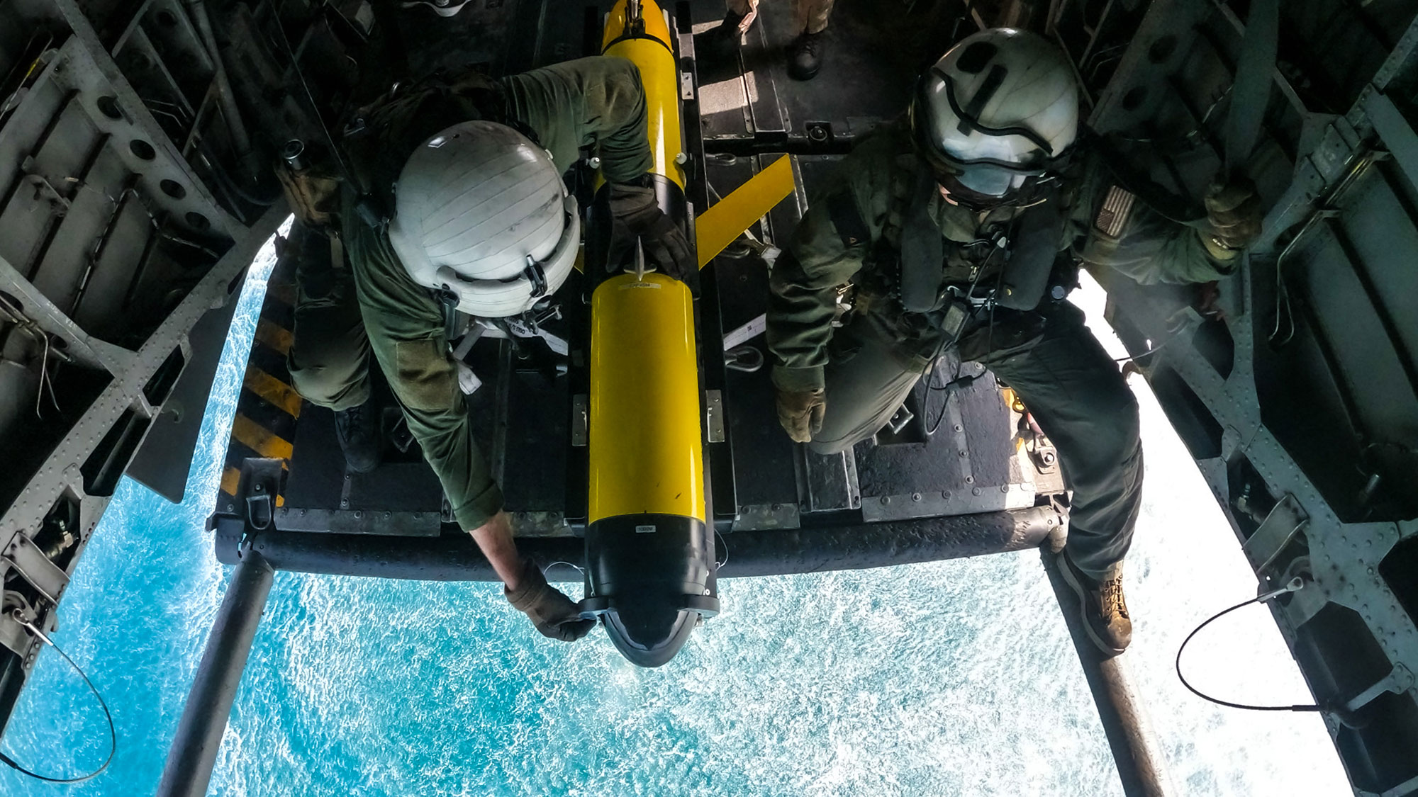
On March 15, the US Navy launched a torpedo-shaped robot into the Persian Gulf from the back of a helicopter. The robot was a Slocum glider, an uncrewed sensing tool that can collect data on ocean conditions below the surface. Dropping it from a helicopter was a proof of concept, a test towards expanding the array of vehicles that can put the robots into the water. As the US Navy seeks to know more about the waterways it patrols, distributing data collection tools can provide a more complete image of the ocean without straining the existing pool of sailors.
The US Navy helicopter, part of Helicopter Mine Countermeasures Squadron (HM) 15, delivered the glider by flying low and slow over the sea surface. The glider, held between railings facing seaward, slid forward, diving but not tumbling into the water. The setup enabled smooth entry into the water, keeping the robot from falling aft over teakettle.
“We are excited to be a part of another series of firsts! In this instance, the first launch from a helicopter and the first-ever successful glider deployment from an aircraft,” Thomas Altshuler, a senior VP at Teledyne, said in a release. While the test took place in March, it was only recently announced by both the Navy and Teledyne, makers of the Slocum glider. “Teledyne Marine takes pride in our continued innovation and support of the U.S. Navy as it expands the operational envelope of underwater gliders.”
This is what that entry looked like:
A second video, which appears to be recorded by the phone camera of one of the sailors standing next to the rail, offers a different angle on the descent. The mechanics of the rail mount are clearer, from the horseshoe-shaped brace holding the glider in place, to the mechanism of release. When the glider hits water, it makes a splash, big at the moment then imperceptible in the wake of the rotor wash on the ocean surface.
For this operation, Teledyne says the glider was outfitted with “Littoral Battlespace Sensing – Glider (LBS-G) mine countermeasures (MCM) sensors.” In plain language, that means sensors designed to work near the shore, and to collect information about the conditions of the sea where the Navy is operating. This data is used by both the Navy for informing day-to-day operation and by the Naval Oceanographic Office, for understanding ocean conditions and informing both present and future operations.
[Related: What it’s like to rescue someone at sea from a Coast Guard helicopter]
In addition to HM 15, the test was coordinated with the aforementioned Naval Oceanographic Office, which regularly uses glider robots to collect and share oceanographic data. The Slocum glider is electrically powered, with range and endurance dependent upon battery type. At a minimum, that means the glider can travel 217 miles over 15 days, powerlessly gliding at an average speed of a little over 1 mph. (Optional thruster power doubles the speed to 2 mph.) With the most extensive power, Teledyne boasts that the gliders can range over 8,000 miles under water, stay in operation for 18 months, and work from shallows of 13 feet to depths of 3,280 feet.
“Naval Meteorology and Oceanography Command directs and oversees more than 2,500 globally-distributed military and civilian personnel who collect, process, and exploit environmental information to assist Fleet and Joint Commanders in all warfare areas to make better decisions faster than the adversary,” notes the Navy description of the test.
Communicating that data from an underwater robot to the rest of the Navy is done through radio signals, satellite uplink, and acoustic communication, among other methods. These methods allow the glider to transmit data and receive commands from remote human operators.
“The invention of gliders addressed a long-standing problem in physical oceanography: how do you measure changes in the ocean over long periods of time?” reads an Office of Navy Research history of the program. The Slocum gliders themselves date back to a concept floated in 1989, where speculative fiction imagined hundreds of autonomous floats surveying the ocean by 2021. The prototype glider was first developed in 1991, had sea trials in 1998, and today according to that report,the Naval Oceanographic Office alone operates more than 150 gliders.
This information is useful generally, as it builds a comprehensive picture of the vast seas on which fleets operate. It is also specifically useful, as listening for acoustics underwater can help detect other ships and submarines. Undersea mines, hidden from the surface, can be found through sensing the sea, and revealing their location protects Navy ships, sailors, and commercial ocean traffic, too.
Releasing the gliders from helicopters expands how and where these exploratory machines can start operations, hastening deployment for the undersea watchers. When oceans are battlefields, knowing the condition of the waters first can make all the difference.
