DRIVE EAST ALONG Baum Boulevard, a four-lane thoroughfare through Pittsburgh’s East Liberty neighborhood, and you may notice something unusual. The road, like many in the largely up-and-coming area, passes auto shops, fast-food joints, brick warehouses, and parking lots that bleed into cookie-cutter luxury apartments and gleaming, glass-faced retail, including a Whole Foods and a Target. As you near the neo-Gothic spire of the East Liberty Presbyterian Church—towering over trendy restaurants, bars, and a Google office—you may start to realize that the lights seem to go in your favor. Red signals turn green, and green ones linger just long enough for you to slip through.
At each junction, a curbside controller cabinet is wired into the signal, and inside is a briefcase-size box made of brushed chrome. The container holds the components of the artificially intelligent Surtrac system, which makes decisions based on what it spies through the city’s traffic cameras. Short for Scalable Urban Traffic Control, it’s one of the first to gather information on vehicular flow and use it to adjust lights in real time—so-called adaptive traffic control. After installation at nine intersections in 2012, travel time dropped by 26 percent and time spent idling at red lights by 40 percent.
Pittsburgh is a prime candidate to pilot Surtrac’s tech. The system came out of Traffic21, a transportation research group at Carnegie Mellon University, and pre-pandemic numbers saw residents lose an average of 45 hours to congestion every year. Though that’s about 10 less than the US norm, according to Texas A&M Transportation Institute’s 2021 Urban Mobility Report, it’s gotten steadily worse since the group began keeping records in 1982.
Generations of engineers have attempted remedies in countless cities, mostly involving redesigning streets. But a seminal 2011 study by two economists—Matthew Turner and Gilles Duranton, then both at the University of Toronto—found that whenever an urban area increased its road capacity, driving increased as well. Their research built on this concept of “induced demand” and put hard numbers to what motorists intuitively knew: Even the widest roads still get clogged.
A history of car-centric planning decisions—from overbuilt streets to ubiquitous free parking—has not only eroded many neighborhoods but also warped how we use and value city space. To help address this, the federal government has mandated that towns dedicate a percentage of their infrastructure investments to “complete streets” efforts that incorporate the needs and safety of pedestrians, cyclists, and transit. Smart signaling, which market analysis firm Navigant Research says will be a $3.8 billion global business by 2028, could help enable that change. If cars move more efficiently across fewer lanes, then municipalities can open up the reclaimed turf. “Adaptive traffic control is making more efficient use of existing roadways and infrastructure,” explains Christopher Leinberger, emeritus professor and chair of George Washington University’s Center for Real Estate and Urban Analysis.
Surtrac has competition for its share of the grid from tech giants and startups alike. Fortunately for the 22 cities already using it—including Atlanta and several New England towns—it’s relatively cheap, it’s easy to install and maintain, and it taps existing infrastructure like streetlight cameras. The computer at each intersection is its own node that crunches a range of scheduling options and then adjusts signal timing every second while passing insights to neighboring lights. This decentralized approach makes Surtrac ideal for regulating unpredictable urban traffic and for gradual expansion.
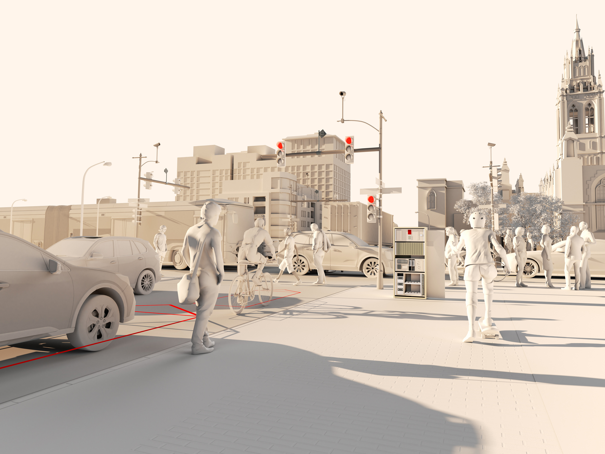
What it’s not exactly ideal for—yet—is pedestrians and bicyclists. People on foot or pushing pedals noticed that they were waiting longer at corners, while cars were idling less. That’s because the system’s data collection tools, primarily cameras trained on vehicles, reflect a bias for cars. It’s a reminder that making efficient use of roads will require updated tech and infrastructure (sidewalks, bike lanes, transit) for walkers, bikers, passengers, and drivers alike.
While the Pittsburgh network has grown to include 50 smart intersections—and the city plans even more—Surtrac’s creators, including CMU research professor of robotics Stephen Smith, have been reworking its analytics. They want to incorporate pedestrian data from a phone app, route info from connected vehicles, GPS pins from electric bikes and scooters, and other data on what’s known as multimodal transit. “Very early on, we started thinking about these other modes of travel,” Smith says.

LONDON INSTALLED the world’s first traffic light in 1868 after two members of the British Parliament were injured and a policeman killed at a particularly chaotic intersection near Westminster Bridge. Its design was simple: At night, a gas lamp signaled red for stop and green for go; in daylight, paddles supplemented the dim glow. As automobiles began to take over downtowns at the beginning of the 20th century, cities scrambled to find ways to keep their streets safe. In 1914, Cleveland introduced the first electric traffic signal, and in 1922, Garrett Morgan filed the patent for a three-position system in San Francisco. Over the decades, timing schemes became more sophisticated, but at its core, the signal is a light on a clock.
The last significant leap took place in the middle of the 20th century, when engineers began developing adaptive traffic control setups. Sensors buried in roadways would collect real-time traffic data to help inform signal timing. Since then, such systems have proliferated, especially in Europe. The Dutch, for instance, tap in-ground sensors to manage flow and prioritize the movement of bicyclists and pedestrians. In the US, however, most signals still operate on a timer system.
In 2009, the billionaire industrialist Henry Hillman decided his hometown of Pittsburgh could do better. Its traffic congestion problems weren’t as bad as those of most large US cities, but Hillman had the means to do something about them. His foundation donated to CMU with a writ to work on solutions—a prompt that eventually led to Traffic21, an institute charged with devising novel transportation tech and using the city as a lab to test it.
Hillman’s grant came at a time when Pittsburgh was looking to reinvent itself. Mayor Luke Ravenstahl dreamed of leading the postindustrial steel town into a new era built on research and entrepreneurship. Traffic21’s executive director, Stan Caldwell, began searching for where to start. Civil engineers consistently pointed to the proliferation of traffic cameras: The tools offered lots of data about how folks moved around, but the people sitting in control rooms didn’t have the training to manage or interpret it. “They were saying, ‘We don’t know how to turn that data into information,’” Caldwell recalls.
Avoiding the high cost of advanced in-ground sensor systems like those in the EU, Traffic21 quickly focused on seeing what it could do with only the lowly traffic signal. The challenge fell to Smith. Over his nearly 30 years at CMU, his research had centered on using artificial intelligence to solve scheduling problems, like managing supply chains or automating emergency responses to natural disasters. He saw potential for applying those skills to traffic.
A few researchers had already tried to use AI for signal scheduling. Smith identified two main problems with those attempts: One was that even advanced systems tended to gather real-time data and use it to refine preset signal timing schedules only every year or so—as opposed to instantaneously adjusting or making predictions. Second, the sophistication of the signals was restricted by the computing power you could fit into a light.
The answer hit Smith, somewhat poetically, when he was stuck at a red light in East Liberty. He happened to glance up at the signal, and he noticed the traffic camera. “It seemed like a low-cost way of trying out the technology since the detection was already there,” he says.
If the eyes were in place, Smith and his team would need only to develop data processing tools powerful and compact enough to fit into the hardware that controlled the stoplights. Many of Smith’s AI systems manage complicated decision making by distributing tasks across teams of “robots”—a concept known as edge computing. With traffic signals, each light could tap computer vision to detect vehicles approaching and leaving the intersection, apply schedule-optimization algorithms to make signaling decisions, and then share that info with other lights in the network.
Because each node handles its own scheduling, the approach is adaptable in unpredictable urban environments. “We wanted to design a system that isn’t thinking about optimizing in one direction that we’ve picked ahead of time,” says Greg Barlow, who was a postdoc in Smith’s lab and is now CTO of Rapid Flow, the company he and Smith founded to market Surtrac.
Many schemes favor one form of transportation at the expense of others, like bicycles and pedestrians.
In 2010, the team approached Pittsburgh’s traffic department to collaborate on developing and rolling out the prototype, and the city helped them select nine intersections in East Liberty. The hardware, about the size of a small desktop computer, was tucked into free shelf space in existing signal control cabinets. Almost immediately, traffic moved more quickly. The cuts in red light idling also lowered vehicle emissions in the area by about 21 percent. With help from East Liberty Development, the nonprofit facilitating the area’s makeover, and others, the city expanded the pilot to 50 intersections.
Pittsburgh was only a finalist for the $40 million US Department of Transportation Smart City Challenge grant in 2016, but the DOT was so impressed with its application it committed $10.8 million to fund connected technology and infrastructure improvements along six major commuter corridors. Pittsburgh now plans to invest nearly $30 million in connecting 150 more intersections. What remains is to make sure its vision of traffic goes beyond cars.
FROM RAPID FLOW HQ in Pittsburgh, Barlow pulls up the Surtrac dashboard and clicks on an icon representing Quincy, Massachusetts, a dense Boston suburb and one of the technology’s earliest adopters. Tiny green dots indicate Surtrac-equipped intersections on the town’s grid, each node holding data like the number and direction of the vehicles that have moved through that spot over the past hour and how the system adjusted timing. Video feeds reveal Quincy on a cold and wet December night. As cars near a signal, the software overlays them with green, yellow, or red boxes: Greens will move through the current “go” signal; reds and yellows tip potential scheduling changes Surtrac has to weigh.
Clusters of boxes represent one of the ways Smith streamlined the data processing demands at each intersection. As vehicles approach, the system attempts to group them into groups that he calls “platoons.” This enables Surtrac to read traffic not as an endless series of individual autos but as a variety of units of different sizes. The AI weighs that information against empty road space and directs the light to move each platoon through, like a postal worker shipping out mail by ZIP code.
Once the autos have moved through the crossing, the computer relays their number, speed, and direction to signals downstream. The traffic light then moves on to its next batch of data, collects inputs from its neighbors, and begins again.
To someone watching the demo, it’s apparent why Surtrac ran into problems in East Liberty. Nick Ross, a bike advocate and Pittsburgh’s chief traffic engineer, says the AI brains have potential, but also blinders. “The initial system was very good at moving cars,” he says. “But it had some of the inherent flaws that have been identified about adaptive systems.”
Ross explains that many schemes favor one form of transportation at the expense of others, like bicycles and pedestrians. As Smith and Rapid Flow prepare to expand Surtrac, they’re working to ease this tension. The system’s intelligence can adapt to different kinds of “jobs” at each crossing. “Our model of moving traffic through an intersection applies equally to pedestrians,” he says. “If there are bike lanes, we can treat those as separate lanes. We can fold all that into the optimization.” What is difficult is developing ways to capture an accurate look at those varied travelers.
Cameras and radar can do some of the work, but blind spots remain. Those preexisting electronic eyes are focused on vehicles, and pedestrians don’t move as predictably as cars—stopping, changing directions, and going against the flow on the regular. That’s why Smith and his team are trying to capitalize on new data sources. The result is Routecast, an update to Surtrac that collects inputs from public transit GPS, connected cars, and willing ebike riders and smartphone-toting pedestrians. During initial tests, the team found that when vehicles share their routes with Surtrac computers, the system can juggle the additional inputs to move all traffic through the network up to 35 percent more quickly. In 2018, Smith’s lab also prototyped an app called PedPal that enables pedestrians with disabilities to communicate with signals to ensure they have enough time to safely navigate an intersection.
In the decade since Traffic21 introduced Surtrac in East Liberty, competing AI signal models have hit the streets. A company called NoTraffic, which has run pilot programs in Arizona and California, installs its own cameras and offloads some processing to the cloud. Another system developed by Siemens Mobility applies machine learning to the problem. There are promising efforts in the works from IBM and the Alan Turing Institute in London. Rapid Flow may be among the most cost-effective of these solutions: $20,000 per intersection, compared to NoTraffic’s $115,810.
There may be other ways for such services to justify their expense, namely by offering a new way to price street use. Governments rely to varying degrees on gas taxes to pay for roads, but an auto fleet shifting toward electric vehicles means they need to find fresh cash flows. “You don’t think about paying for the roads as you drive, and therefore you use them because they’re free,” urbanist Leinberger says. “One solution is to get away from gas taxes and to properly price it per mile every time we drive.” That’s why some locales are considering AI-based curb management systems that help regulate limited street-side space. By monitoring delivery and ride-share companies that use curbs, municipalities can attach prices that match what accommodating them costs.
At the same time, tech that helps balance competing modes of travel offers an avenue to safer streets, even when exiling autos from certain zones the way cities like London and Brussels have isn’t feasible. Surtrac’s work in East Liberty improved flow without seeing a spike in congestion the way adding lanes would have. That means the streets could get narrower, making room for pedestrian and bike infrastructure without worsening traffic.
How officials choose to balance those priorities, however, is beyond any AI’s control. Smith’s robot traffic signals may be as clever as almost any piece of buzzy “smart city” infrastructure, but deciding how we want to shape our future cities is on us.
This story originally ran in the Spring 2022 Messy issue of PopSci. Read more PopSci+ stories.
