Point, Click, Rescue This image shows an example mosaic generated by a search-and-rescue drone. The dotted circle shows where a dummy was dropped off in the Utah wilderness. A human operator spotted the "missing person," but the researchers are working on object-detection algorithms that would allow the drone to find the missing person. Brigham Young University

Unmanned drones could make searching for lost hikers much cheaper, faster and safer than using helicopters, according to researchers at Brigham Young University in Utah. They are turning drones, best known for their search-and-destroy capabilities, into search-and-rescue vehicles.

When hikers go missing in the mountains, search-and-rescue (SAR) teams mobilize in a complicated and very expensive operation to find them. The National Park Service alone spends about $4 million a year rescuing the lost, and that’s saying nothing of individual city and county expenses. What’s more, search teams can be imperiled by bad weather.

The drone project simplifies all this by equipping a miniature aircraft, just a 4-foot wingspan, with a video camera. A SAR operator directs the plane by clicking on a computerized map. The plane can also work autonomously, by analyzing the terrain and using probabilistic models to determine a lost person’s likely route.

Experienced SAR team leaders helped develop the autonomous search algorithms, the authors note. Lost hikers may seem to wander randomly, but they usually seek lower, flatter ground. The plane analyzes terrain maps to predict where a hiker might end up.

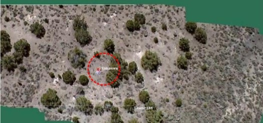
In trials, operators using the craft have taken between 35 and 150 minutes to find a dummy dumped in the wilderness, according to a report on the research in New Scientist.

The research team, led by Lanny Lin, Michael Roscheck, Michael A. Goodrich, and Bryan S. Morse of BYU’s computer science department, led a trial last fall in which they spent 30 minutes training a SAR team leader on how to use the drone. Afterward, it took him 35 minutes to locate a dummy they dropped in the Utah wilderness, according to the team’s paper (PDF).

So far, a human operator is needed to spot the missing person, because the UAV’s visual-detection algorithms aren’t advanced enough yet to find a person in the photos.

A paper on the team’s work was presented this week at the AAAI Conference on Artificial Intelligence in Atlanta.

[New Scientist]

7 Comments

I worked on a VERY similar project as a senior at the United States Air Force Academy in 08/09 that was capable of locating car-sized objects very accurately. This actually doesn't seem like news to me, but rather a few steps sideways, if not backwards. I don't mean to discredit their work, but to point out that others have already accomplished these feats without the recognition.

In addition to object identification, another part of our team was working on swarming algorithms for combined searches with multiple aircraft. If one found a potential object, the others were called over to verify the finding. All of this was done autonomously.

Anyway, in order to tie into this article, the "lost hiker" would simply need to lay out something like a blanket or tarp in order to be found with the algorithms we were using. Even someone who couldn't move (after a fall or something) would be able to do that.

LJRoberts20...you have to remember that a lot of tech that the military has never gets to the private sector.
Or if it does, it is many years later.

I have seen stuff in the Navy years ago that still makes current tech look like atari-level quality.

I've also seen tech in the navy that makes this look like aliens made it and gave it to us lol Some things in our military need updated badly!

wouldnt drones with thermal imaging be better suited? autopilot flight pattern linked to a monitor...maybe 5 drones at once over a very large area? wouldnt only take 1 person to view all the monitors at once. Heavily forested areas wont let the drone see the person, and this would be useless at night?

I really like the thermal imagining idea. I don't think it's especially useful for locating people by their own natural heat signiture, just because of all of the false positives from wild life.

Lighting a small contained fire is already a known way of signaling for help - and tuning the sensors to find fires could double as a an automated "first responder" for wild fires.

It would potentially be just as effective during the day is it is during the night.

If one were to go completely automated, you'd have to make it understand which areas to give less sensitivity - otherwise bbqs and chimneys are going to set off a bunch of false positives, just like the wildlife indicated above.

There is a vast difference between what the DoD has in terms of capabilities verses what the civil community has. This is one of the main reasons I founded VIASAR (www.viasar.org). We're attempting to transition defense methodologies and technology for search and rescue into the civil community. It's a slow process, but we're making some headway working with partners within the Air Force Research Laboratory (AFRL), the Air Force Institute of Technology (AFIT), and others.

Fortunately, photo reconnaissance and analysis are really taking off in the civil community and some groups are adding this to their suite of tools. The main problems are that the civil search and rescue community is highly disconnected and decentralized, poorly funded, and not well trained in the use of technology. These efforts are really in their infancy. One group that recently started using recon is the Portland Mountain Rescue group out of Portland, OR. Another is the Down East Emergency Institute (DEEMI), who have been doing it for several years.

Thermal and infrared imaging can be useful, but are subject to problems, like thermal-crossover, which limits when and how collection is accomplished. Plus, the visible footprint of most commercially available sensors is too small to make them very effective. Good collection methodology is a must when employing these types of sensors. I'm working with AFIT on a project, which uses a multi-band thermal-imager to focus on human skin detection - really cool, exciting stuff.

Multi/Hyper-spectral data also shows a lot of promise. These types of sensors are really expensive and highly technical though. I hope to see training for a new breed of search and rescue analyst come along soon. Until then, we'll continue to use lean, light, relatively inexpensive, and easy to use systems, like the VIASAR-CAM. The system uses a hand-held camera body, GPS, and IMU connected to a laptop computer. It can be shipped via mail, set up rapidly in nearly any platform, and ready for use right away. The output is standard RAW, TIFF, or JPEG files, which can be geo-registered.

Wow...I got carried away...

^ holy f***

38KKK
*D Ace Lee*
\m/(>.<)\m/


June 2013: American Energy Independence

Five amazing, clean technologies that will set us free, in this month's energy-focused issue. Also: how to build a better bomb detector, the robotic toys that are raising your children, a human catapult, the world's smallest arcade, and much more.


Online Content Director: Suzanne LaBarre | Email
Senior Editor: Paul Adams | Email
Associate Editor: Dan Nosowitz | Email
Assistant Editor: Colin Lecher | Email
Assistant Editor: Rose Pastore | Email

Contributing Writers:
Rebecca Boyle | Email
Kelsey D. Atherton | Email
Francie Diep | Email
Shaunacy Ferro | Email

circ-top-header.gif
circ-cover.gif
bmxmag-ps