This article was originally featured on Knowable Magazine.
Over millions of years, the Earth’s upper layers have performed a dance that has created mountains, volcanoes, continents, ridges and ocean trenches.
Tectonic plates play a key role in this process. These huge, irregular slabs of the Earth’s crust—the solid rock surface where humans live—and the upper part of the underlying mantle “float” on a deeper, warmer layer of the mantle. When two plates meet, sometimes one gives way and ends up sinking little by little into the depths, in a process known as subduction.
If the phenomenon occurs along the entire length of the plate boundary, a line of volcanoes, known as a volcanic arc, forms. There are volcanic arcs in the Andes of South America, Tonga in the South Pacific Ocean, the Aleutian Islands of Alaska, the Philippine Islands and Central America, among others — all of them part of the Pacific Ring of Fire, where earthquakes and volcanoes are common.
The Central American arc is relatively small, just 1,100 kilometers long. But it contains an important variety of different types of magmas, some of which are unique on the planet. It is a “geological paradise” hiding secrets worthy of investigation, says Esteban Gazel, a geochemist at Cornell University in Ithaca, New York. “Central America has a rich combination of conditions that allow the comparison of different natural experiments in magma generation,” he and his two coauthors wrote in a review published in the 2021 Annual Review of Earth and Planetary Sciences.
Central America was born on what used to be an oceanic plate, as a consequence of the subduction of tectonic plates. About 150 million years ago, a slow process began that gradually allowed volcanic islands to grow between the continental masses of northern and southern America. About 3 million years ago, the area now comprising Costa Rica and Panama was finally joined to the north of present-day South America, creating a single landmass from Alaska to Tierra del Fuego.
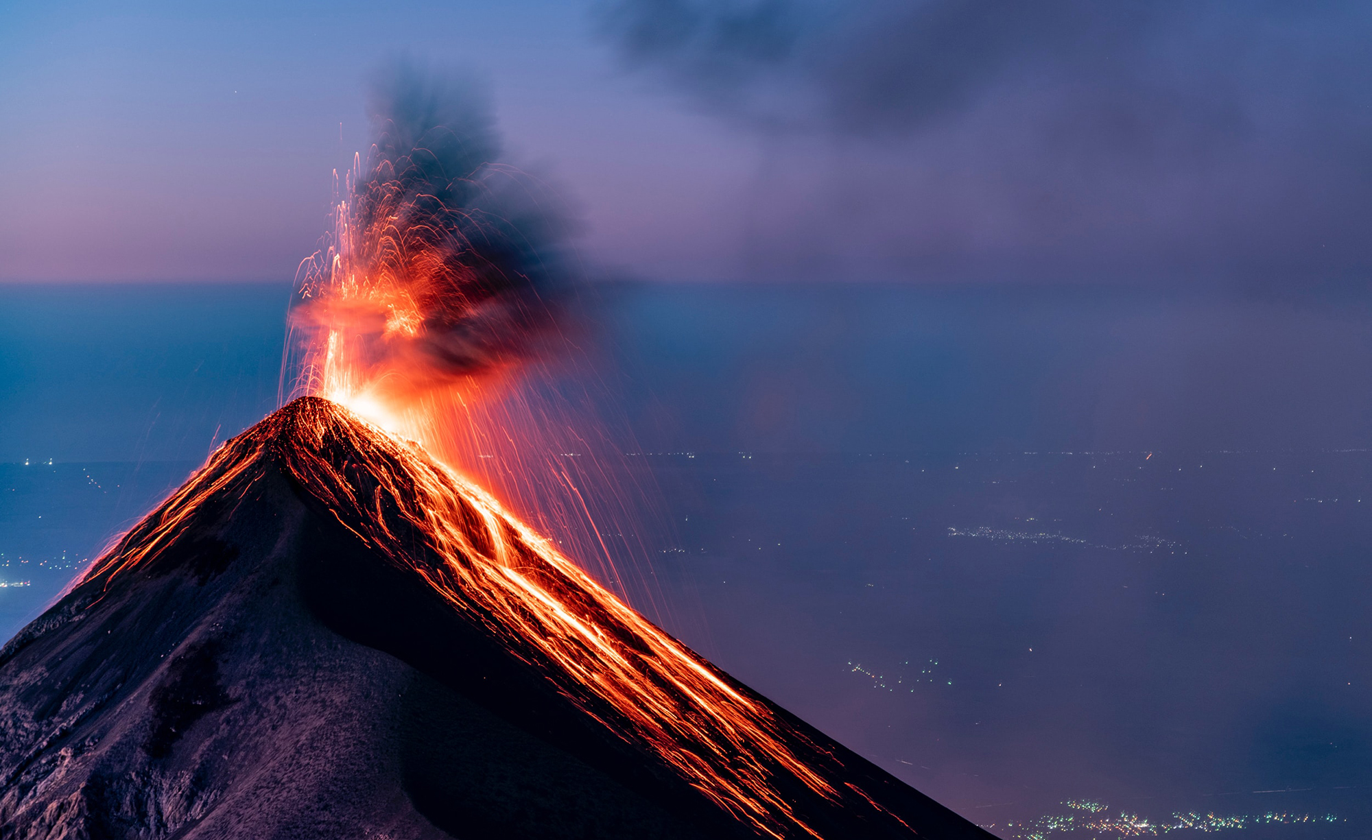
In the last 11,000 years, 70 volcanoes have been active in this part of the Ring of Fire. Just as volcanoes have created fertile lands where agriculture and cattle-raising have flourished, they have also brought death and displaced populations. In 1902, for example, following a series of earthquakes in the region, the Santa Maria volcano in Guatemala recorded one of the largest and most explosive eruptions of the 20th century. In 1968, an eruption of the Arenal volcano in Costa Rica left 78 dead; and in 2018, the Fuego volcano in Guatemala erupted, killing more than 100.
Gazel carried out his first studies as a geochemist in Costa Rica, his home country. In this interview, edited for length and clarity, he explains how the geology of Central America helps us understand the evolution of our planet.
What is the Central American volcanic arc?
It is an alignment of dozens of volcanoes, not all of which are currently active, stretching from the border between Mexico and northern Guatemala to central Costa Rica. Among them are the volcanoes of Fuego and Tajumulco in Guatemala, Santa Ana in El Salvador, Masaya and Momotombo in Nicaragua, and Arenal and Poás in Costa Rica. This arc is the result of the subduction of the Cocos plate under the Caribbean plate. The Cocos plate is produced in a ridge in the Pacific Ocean. The ridges are submarine fractures through which magma emanates. When magma comes out at a ridge, it pushes the plates, cools, crystallizes and creates new crust.

When the plate subducts, it is filled with volatile elements, mainly water and carbon dioxide. At about 60 kilometers deep they become unstable. Because of the high pressure and temperature conditions at those depths, the minerals will break down and the volatiles will come out in a very special form: a hybrid between a liquid and a gas, which is known as a supercritical fluid or a melt. This fluid interacts with the rest of the materials and fuses the rocks of the mantle. This is the process that generates the magma that comes to the surface in the form of lava.
When did this process begin?
We have a history of volcanism in Central America going back many millions of years. The arc has been growing and evolving, creating different versions. It began to form about 150 million years ago, at the time of the dinosaurs.
The tectonic system moves and accommodates itself. For example, the Cocos plate does not have the same subduction angle along the arc’s 1,100 kilometers; the way in which it enters under the Caribbean plate—its entry angle—is different in different areas. This affects the formation of the arc.

For example, some 20 million years ago, the arc was where the San Carlos plains are—north of what is now Costa Ric —and to the east of today’s Nicaragua Lake. It resembled today’s Mariana Islands [a group of islands aligned north to south, close to each other and located southeast of Japan]. The arc continued to where Chiapas is today, in Mexico.
Today, the arc is closer to the Pacific coast in northern Central America and toward central Costa Rica. Most of the volcanoes you see today are 500,000 to 250,000 years old. But there are also younger volcanoes. Nicaragua’s Cerro Negro is the youngest, dating from 1867.
The Earth evolves and leaves old versions. The pages of the evolution of the planet are written on these rocks.
What makes the Central American volcanic arc unique?
It is something incredible. The geochemical variations from Nicaragua to Costa Rica are the most extreme on the planet. Throughout Italy there are magmas similar in chemical composition to those of Costa Rica, but all those volcanoes in Italy are going to be very similar to each other.
In the Mariana Trench in the western Pacific Ocean, the magmas are very similar to those of Nicaragua, but all the volcanoes in the Marianas produce magmas very similar to each other.
Italy and the Mariana Trench are separated by thousands of kilometers, while Costa Rica and Nicaragua show important geochemical differences in their magmas even though they are very close. The extreme amount of variation in such a small area makes Central America the only place on the planet with these characteristics, and therefore a unique natural laboratory.
Why is there so much variation?
The regional variation is controlled by the angle of subduction and the composition of the subducted material. The local variations of Central American volcanoes are controlled by the volume of the volcano. Very large volcanoes have more molten material coming from the mantle and less variability. In contrast, smaller volcanoes have much more geochemical variation. Large volumes of magma homogenize the signal, and smaller volumes show us more extremes.
Central America also has a combination of denser oceanic crust and lighter continental crust. What does this mean and what does it teach us?
It is something very unique to Central America. In the Mariana Trench, the whole arc is developed in oceanic crust. In the Andes, in South America, the entire arc develops in continental crust. In Central America, the arc starts in continental crust in Chiapas and Guatemala, and when we enter Costa Rica, we enter the oceanic crust. All the magmas in Costa Rica are oceanic arc magmas that look very much like the Marianas, until about 15 million years ago when things start to change again, and the magmas in Costa Rica start to look more like continental crust. This tells us that this is a very dynamic zone.
Why does this happen?
Fifteen million years ago, a much younger crust began to reach what is now Costa Rica, with the Galapagos seamounts—submerged oceanic islands in the Pacific Ocean that once were like what are now the Galapagos Islands of Ecuador. That is what is known as a hot spot, a thermal anomaly that brings material from the Earth’s lower mantle. These islands travel with the plate, submerge, and eventually collide and enter the Costa Rica-Panama subduction zone, where the Cocos plate dives under the Caribbean plate.
This plate has a unique geochemical signature that shows up in the volcanoes of Costa Rica and Panama. The conclusion from a lot of my work over the years is that Costa Rica was not continental crust, and since about 15 million years ago one of the youngest continental crustal terranes [fragments consisting of a distinct and recognizable series of rock formations that has been transported by plate tectonic processes] on the entire planet has been formed by the melting of these seamounts in the subduction system. So it is also a natural laboratory.
Cocos Island [an island and national park located in the Pacific Ocean, some 500 kilometers off the Costa Rican coast] is part of a series of seamounts. These mountains are entering the subduction zone and are melting. As the crust evolved from oceanic to continental, its density was reduced, allowing Costa Rica and Panama to emerge from the sea. This process contributed to the closure of the Central American isthmus, which finally occurred about 3 million years ago. The birth of the volcanic arc helped to generate sediments in the area, and tectonic activity raised the surface until a complete closure occurred.
So, is Cocos Island getting closer to the mainland?
Yes. In several million years, it will subduct and then come out again as a volcano like Poás or Irazú in central Costa Rica today, where the Galapagos signature is extremely evident.
What are the tools you use to investigate volcanic arcs?
The main tools are the volcanic rocks, obtained after an eruption, because their chemical composition is controlled by these processes. We analyze them using electron microscopes, spectroscopes and mass spectrometry to infer their origin, age and evolution.
How has your field evolved over the years?
I started doing research in volcanology and geochemistry at the Nuclear Research Center of the University of Costa Rica. I started there because geology and volcanology at that time were very descriptive. The nuclear physics researchers implemented more quantitative measurements. When I started my career in the United States, my science evolved to be much more numerical and less descriptive.
In the last decade, and especially the last five years, as a community we have moved to a volcanology that is incredibly precise and quantitative.
That’s only going to continue to expand. We’re already at a point where to be a modern geologist you have to know about geochemistry equipment, about programming, about statistics. Now there is machine learning and artificial intelligence, and all those tools are being used along with field and laboratory data.
Geologically, what does the future hold for this region?
What we must understand is that in Central America we live in a tectonic and volcanically active zone. Prevention and good construction really make a significant difference to save lives in the face of eruptions and earthquakes. Because volcanoes are going to keep erupting and earthquakes are going to keep happening. It is the natural process of evolution.
What new research is coming up?
In January 2024, a group with professionals from different parts of the world will go to Poás volcano in Costa Rica to test new technologies to study volcanic processes and with the goal of someday having a better idea of how to forecast a volcanic eruption. The person organizing it from the United States was my post-doc mentor.
And my lab was just funded by the US National Science Foundation to study Plinian eruptions of mafic composition. Plinian eruptions are the highest-magnitude eruptions, like the Vesuvius eruption that destroyed Pompeii. They are generally felsic, meaning they are high in silica. However, there is a group of mafic eruptions that are high in magnesium and iron that also have that magnitude. In Central America, Nicaragua’s Masaya volcano holds a record for one such eruption.
How can Central America teach us about Earth’s formation more broadly?
If we want to understand how the continents were formed in the early part of the Earth’s evolution, one of the best places to work is Central America.
If we want to study the process of subduction, how it starts and how the composition of continents changes, we have that history in Central America.
If we want to study samples of materials that traveled to the interior of the Earth, that “visited” the mantle in a subduction zone and came up again, they are exposed in Guatemala.
If we want to understand the mechanisms that start very high-intensity eruptions, we have a record of eruptions in Nicaragua and Costa Rica.
So Central America is already a natural laboratory, and it will continue to be a place where many geological processes can be studied.
Additional examples where Costa Rica has something that is very unique are the exposed oceanic crust on the Nicoya Peninsula and the exposed mantle on the Santa Elena Peninsula. In Santa Elena, we have the terrestrial mantle exposed, and you see rocks, known as peridotites, which formed at depths of 50 to 70 kilometers and were brought to the surface by tectonic activity. These are incredibly unique and very interesting sections, which have been the focus of many years of research that have allowed us to better understand the structure, composition and history of the mantle.
Central America will continue to be studied for its diversity: a geological paradise.
Article translated by Debbie Ponchner
This story is part of the Knowable en español series on science that affects or is conducted by Latinos in the United States, supported by HHMI’s Science and Educational Media Group.
This article originally appeared in Knowable Magazine, an independent journalistic endeavor from Annual Reviews. Sign up for the newsletter.
