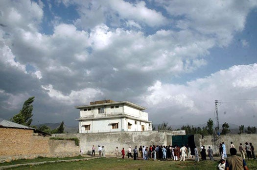
American intelligence agencies are hoping to turn propaganda videos, images captured from enemy data caches, and other pics snapped with or without the subjects’ knowledge into readymade geolocation tags via a system that can identify exactly where any photo was taken anywhere in the world. If successful, such a tool could turn images captured from enemy hard drives--like those snatched from Osama bin Laden’s Pakistan compound back in May--into the makings for a point-by-point Google map of terrorist travels.
Of course, intelligence analysts do this already. Gathering as much info as they can from images--flora, fauna, architecture, topography, local garb, etc.--they try to establish, at least within a reasonable margin of error, where a photo may have been taken. But this method is imprecise, slow, and extremely labor-intensive. Automating the process could produce better, more actionable intelligence. That’s the idea anyhow. First engineers have to make it work.
The Finder Program, as it is known, was commissioned by IARPA (it’s the DARPA of the Intelligence community) to incubate a computer technology (read: powerful algorithms) that can automate this process while reducing the time it takes to analyze intel, making that intel more accurate/actionable. It wants software that, with the help of a human analyst, can look at any image or video taken outdoors anywhere on the land surface of the world and extrapolate the GPS coordinates.Presumably it would do this via a blend of publicly available satellite imagery, not-so-publicly available satellite imagery, and the universe of geotagged photos already floating out there on the Web (thanks, Flickr). That, and a whole lot of computing power.
It’s a tall order, but one with the capacity to drastically alter the way intelligence agencies hunt terrorists (and that’s not even accounting for the law enforcement applications). Moreover, it could rob politically-driven terrorists of a key PR tool, making those propaganda videos depicting terror-trafficking bad guys lazing in their remote mountain hideouts and training camps a dangerous gamble.
Five amazing, clean technologies that will set us free, in this month's energy-focused issue. Also: how to build a better bomb detector, the robotic toys that are raising your children, a human catapult, the world's smallest arcade, and much more.


Online Content Director: Suzanne LaBarre | Email
Senior Editor: Paul Adams | Email
Associate Editor: Dan Nosowitz | Email
Assistant Editor: Colin Lecher | Email
Assistant Editor: Rose Pastore | Email
Contributing Writers:
Rebecca Boyle | Email
Kelsey D. Atherton | Email
Francie Diep | Email
Shaunacy Ferro | Email
Suddenly the all terror organizations shoot their videos with images of the Grand Canyon, the Washington Monument, the Moon and the Marianas Trench behind them.
@Igot1forya:
You're absolutely right! Why do our "intelligence" agencies feel it is a good idea to make these projects public knowledge. Most videos that these groups release are already void of any landmarks.
I believe Google Images already lets you search for things like that in pictures. DARPA just needs to hire Google already and get all the stuff they want done the right way.
@armymustang_67
I thought the same thing. When I read the title of the article, my exact thought was, "wtf? we don't already have that?" If you don't even consider the Google tech, I can't really believe the US doesn't already posses this type of thing. Just baffles me.
Oh just tie it in with Google Street maps view and you can locate anything anywhere easily ha.
Just have a software that interlinks with the satalites to process the images of every building or every picture that analizes the geological and arcitectuarl features of the buildings in the picture. wouldn't that work.
In energy healing, a photograph of the person who has a health issue is taken and placed in the frequency witness box of the computer.
The computer then can determine exactly what is the condition of the person and then clear it. In my case, the photograph was taken and after a few minutes as I was sitting in another room, the woman operating the computer reported that I had too much CO2 in my body.
Then I realized that I had been drinking too many carbonated sodas!
That is, any photograph contains the frequency of the location shown in the photograph. For example, after remote viewing a computer center with many terminals somewhere in the world, it was a simple matter to locate the computer center on a world map. The map showed the geography as had been seen in the remote viewing session.
Using these techniques, it is possible to detect where WMD are located, eliminate the undignified TSA grope downs at the airport, spot all terrorists without having to put FBI GPS trackers on cars, spot shoplifters at the supermarket, reduce all military hardware by entering the bodies of foreign soldiers and force them to surrender, create invisibility cloaks by activating the third eye of enemy snipers, walk through walls and hyperspace co-dimension, provide energy healing to veterans by removing the morphic field of war from their auras and a host of other things.
johnstclair
you are out there....
I believe they can do this for night photos simply by using constellations if there is a piece of sky in the photo. But for example in that picture above that obviously wouldnt work. Maybe if they figured out the altitude of that ridgeline in the background along the whole thing they could match it to a known mountain range...
@bjorn - There is an Apple app which when pointed to the night sky identifies the stars that you are looking at. It uses GPS and the accelerometer.
So maybe it might be possible to write an app in which you touch the screen to enter star positions or take an iPod photo of the real photo. The star database would search through and find the location, correcting for the viewpoint offset.
When I was remote viewing the alien spacecraft that crashed in Russia as seen in the Roger Moore video, I wanted to know if the side shown was the bottom or top of the hull.
I received help by someone who said he could go back in time and walk around the crash site. He traded off space for time. After walking around the craft, he informed me that it was the bottom of the spacecraft. I was totally amazed at his abilities.
With this information, I was able to notice the U-shaped dual folding space waveguide which they put on the bottom. This waveguide is what is used to make those incredible 90 degree turns, or compress space-time for propulsion.
Because the spacecraft was out of dimension, it became embedded in the earth without any debris throw up. It merged with the earth as it came back into dimension.
A picture of the captured dead alien can be seen on earthfiles.com as well as autopsied in the video. He has a series of bony breast plates.
The guide shows the tourist around the compound. "As you look here is “Bin Laden's Compound ", walking walking "and if you look over there you can see the India Military Academy to the left."
One of the people from the tourist group ask the guide: “Why are all the windows to the Academy painted over? “
the guide replies, " Please hold all your questions, until later, thank you!
"Keep walking walking, good, good."
In 2004, remote viewers were in bin Laden's mountain cave hideout, but Defense Secretary Rumsfeld wasn't interested in the information.
@JohnStClair, YOUR COMMENT RANDOM and nothing.
@BubbaGump - I don't understand your joke. You mention India Military Academy as nearby.
I thought bin Laden's compound was next to the Pakistan Military Academy.
Explain??
When the remote viewers were in his mountain cave, it turned out that Muslims from India were bringing in the dialysis equipment hidden by a herd of goats in the back of a truck.
At the mountain, the goods were loaded on the goats for transport up to his hideout.
What I am saying is that photographs are a frequency witness by which the location can be remote viewed. There is no need for software or any devices to do this.
@JohnStClair, your right, I goofed, I feel a Simpson sound coming on, " DOPE! "