The Dictionary of Hurricane Sandy: Storm Surge
A lot of meteorological terms will be thrown around for the next few days. We're here to define them so you can understand what's going on. Welcome to the Dictionary of Hurricane Sandy.
Storm Surge [ˈstȯrm ˈsərj]
During a hurricane, a storm surge is usually the greatest threat to life and property. The disaster associated with Hurricane Katrina, as most will recall, was pretty much all derived either directly or indirectly from the storm surge. And while most people probably have a pretty good idea of what storm surge is, there is some nuance here that is worth noting.
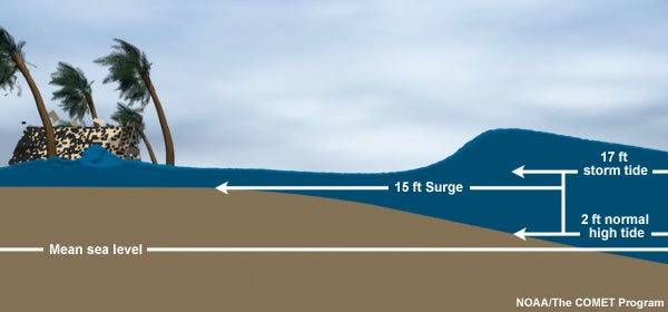
Storm surge by definition is the atypical rise of water generated by a storm that is not attributable to astronomical tides (the combined effect of storm surge and water level rise caused by the tide is known as “storm tide”). Surge is mostly attributable to the storm’s cyclonically rotating winds driving water toward the shore rather than by air pressure (that’s a common misconception), though pressure does play a small contributing role. Storm surge is also notoriously difficult to predict. It is extremely sensitive to small changes in the storm’s intensity and is influenced by a number of external factors as well. Among them: the width and slope of the continental shelf near coastlines, and other characteristics of coastal areas, like the shapes of inland waterways, bays, or estuaries.
In the case of Hurricane Sandy, what we’re particularly worried about is the storm tide–the rise in water levels caused by the combined effects of storm surge and the astronomical tides, whose timing couldn’t be worse (see our entry on spring tide). Most people will refer to this combined effect simply as the storm surge rather than the storm tide, and that’s fine; in casual, non-scientific usage, “storm surge” has come to represent all the water that comes ashore during a storm (including freshwater flooding), and really that’s what we’re concerned about regardless of what astronomical, geographical, or meteorological catalysts caused the water to come inland. But now you know the difference.
Read more entries from the Dictionary of Hurricane Sandy here.