Portable Gamma Camera Displays Radioactivity in Real Time
Tracking down radiation hotspots is tricky and time consuming because it’s hard to see where the problem areas are. Radiation...
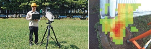
Tracking down radiation hotspots is tricky and time consuming because it’s hard to see where the problem areas are. Radiation doesn’t spread itself evenly over an area, and as such it can be hard to find the spots within a contaminated area that require cleanup and differentiate them from the places that do not (typically this is done by walking around waving a handheld meter around, a process that is really, really slow). To simplify the task, Toshiba has developed what it’s calling a Portable Gamma Camera that mashes up gamma ray data with image data to create visual radiation heat maps on the fly.
The camera itself is the size of a large camcorder and records both image data through a normal camera sensor and radiation data via embedded semiconductor detection elements built into the camera. Then, via a signal processing device, it combines the two into a single image that superimposes the radiation data onto the visual image on the camera’s display.
Color coding like a weather map (red for “danger” down through oranges and yellows to greens for “okay”) tells the user where radiation is the highest and how high it is, allowing workers to quickly survey an area and mark it for cleanup. It also serves as a fast and efficient way for cleanup crews to check their work and make sure they’ve completely cleared an area of all radioactive hotspots before moving on.
Toshiba will field trial the Portable Gamma Camera in collaboration with Fukushima City in Japan this month. If all goes well, the camera could go into regular use within Japan’s central and local governments early next year.