Learn how changes to the Clean Water Act could hurt your region before it’s too late
The public comment period ends April 15.
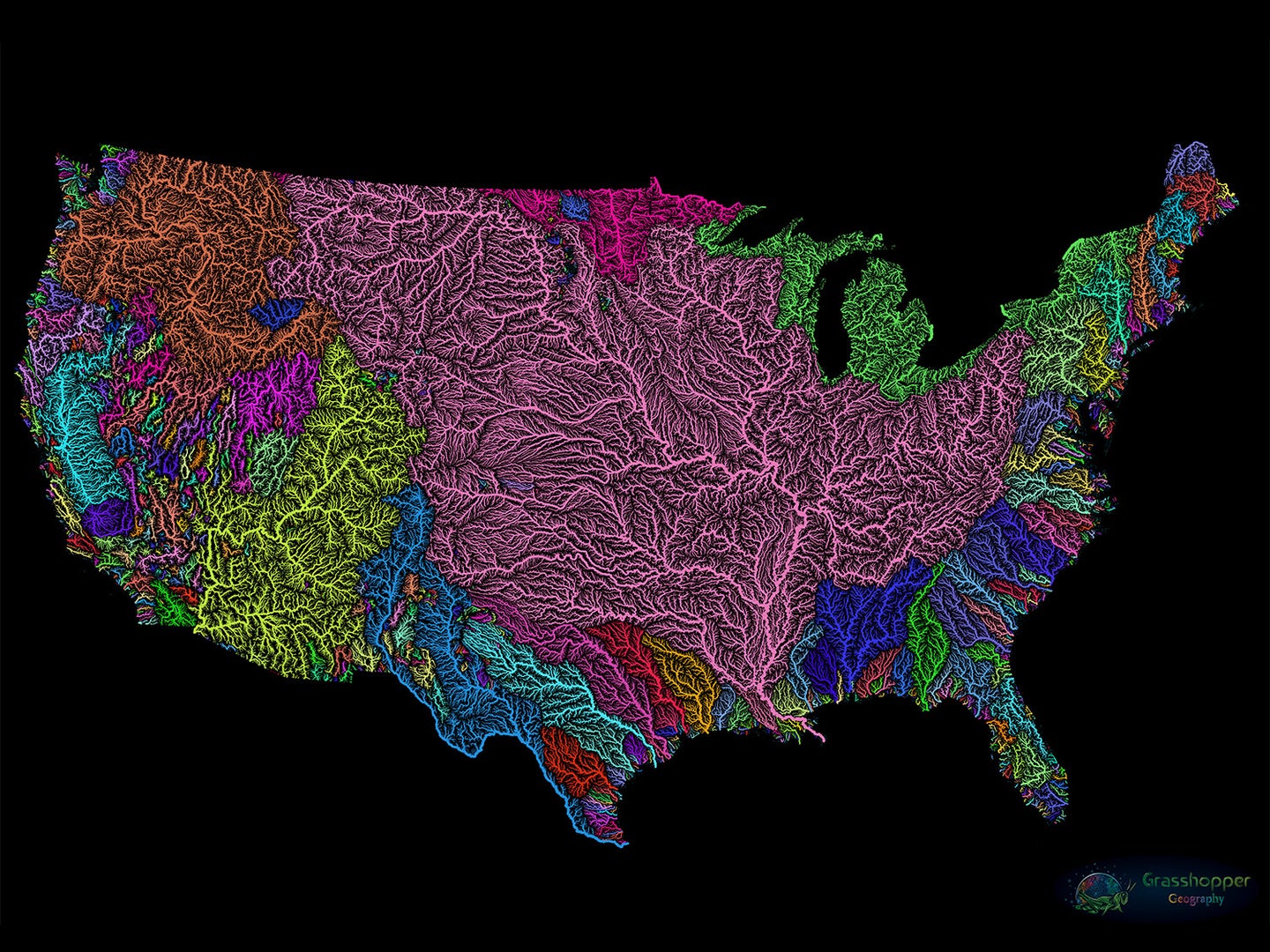
The Environmental Protection Agency has made moves to shrink national water protections for two years. In July 2017, the EPA and Army Corps formally proposed rescinding the Clean Water Rule; a proposal that has not yet been finalized. Then in February 2018, the agencies suspended the Clean Water Rule until February 2020. Now, it’s go time: The administration is proposing revisions to the Clean Water Act, introduced in 1972 as a way to curb widespread pollution in United States waterways. The would-be replacement is rife with rollbacks that would affect every American. Lawmakers, scientists, and the general public have until April 15 to submit comments on the proposed changes, so we’ve compiled a list of threatened waterways in each region to help inform your feedback. Scroll through and find the Environmental Protection Agency Region to which your state belongs. But first, some background:
What is the Clean Water Act?
The Clean Water Act requires anyone who wishes to conduct business that could pollute waters of the United States (WOTUS) to first apply for a permit. A 2015 addition to the act, called the Clean Water Rule, expanded this red tape to some temporary (meaning they don’t flow year-round) and isolated (meaning they aren’t visibly connected to another body) waterways. The Trump Administration has already suspended the Clean Water Rule and wants to permanently kill it, as well as some protections that were in place before 2015. They can do this by redefining what counts as “waters of the United States.”
This definition determines which waterways the federal government regulates under the Clean Water Act. Suspending the Clean Water Rule would make it easier for industries and cities to pollute small or visually isolated water bodies. For example, under the new rule, you still could not dump toxic waste into the Mississippi River. But you could dump it in some smaller streams or wetlands, even if they provided crucial habitats to certain animals or could indirectly contaminate sources of drinking water.
Proponents of the new definition say the Clean Water Rule is the product of government overreach, that it hurts the economy, and that the new regulations would simply clarify which waters are and are not included. Opponents say removing these baseline protections would have consequences and would undermine the 1,200 science studies that informed the Clean Water Rule. “In providing this clarity from the onset, it removes Washington bureaucrats from making ambiguous decisions on land which they aren’t familiar with, as landowners are,” the EPA’s website claims.
But without the baseline protections the new definition cuts out, it will be nearly impossible to keep interstate waters clean; every state has different local regulations. Local waters in states that adhere to federal government standards and nothing more would be hit the hardest, but that pollution would spread downstream, across state lines, and into larger rivers, estuaries, and lakes.
On a national scale, the proposed changes to the Clean Water Act would lift federal protection for sources of drinking water for 117 million––or one in three––people living in the lower 48. It could exclude as much as 70 percent of rivers and streams and at least half of the nation’s wetlands. Aside from being critical habitat for plants and animals, including one-third of bird species in the United States, wetlands help mitigate floods by absorbing excess water instead of letting it run off into overflowing streams. They recharge groundwater reserves and filter pollutants such as nitrogen and phosphorus that cause toxic algae blooms.
Polluted waterways are not an environmental issue of the future; they pose an immediate danger that we have the ability to prevent. Before you keep reading, here are some terms you’ll want to know along the way:
Navigable waterway: Think of these as the larger bodies of water you’re probably most familiar with. The definition relies heavily on how valuable the river is for commerce, but it’s also based on size. Many have their own standards outside the Clean Water Act, and the administration agrees we need to protect these. But because small waterways funnel into navigable waters, and wetlands filter pollutants such as nitrogen so that they don’t end up in them, the protected waterways will still be affected by proposed rollbacks.
Headwaters: These small streams are where larger rivers get their start. Headwaters account for more than half of all stream miles in the United States and provide the majority of flow into large rivers.
Ephemeral streams: These temporary streams flow only after it rains, and run dry for a lot of the year. None of these would be federally protected under the new Clean Water Act, but they can be crucial to our well-being and that of our ecosystem.
Intermittent streams: These seasonal streams usually carry melted snow or runoff from other streams, wetlands, or surface water from cities. They don’t flow year-round, either drying up when water gets scarce or flowing unseen beneath the ground. Under the proposed change, intermittent streams would be evaluated on a case by case basis, based on 30-year flow averages. Some worry that these numbers could be skewed in favor of industry.
Perennial stream/river: These are typically fed by headwater and ephemeral streams or lakes and flow year-round. They’re usually larger tributaries to navigable waters—or considered navigable themselves—and for the most part, would still be federally protected.
Significant nexus: Defined in the Clean Water Rule as being connected to a navigable waterway, even if humans can’t see it.
Adjacent waters: The Clean Water Rule identified adjacent waters as bodies near navigable water that have a significant nexus, even if we can’t see it. This is important because small, unseen connections can enable contamination from an unprotected waterway to flow into a protected one. The rule also said that water within a certain distance from a navigable waterway was protected, which the original Clean Water Act did not do.
Surface water connection: Water that flows above ground from one body of water to another. This is how the new rule will determine whether a waterway has a significant nexus––or connection––to a navigable waterway. This is problematic because many waterways are connected through underground channels.
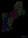
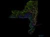
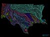
Region 1
Connecticut, Rhode Island, New Hampshire, Maine, Massachusetts, Vermont: Strong state regulations that rely on federal funding
New England’s waterways have plenty to contend with; the region struggles with chemicals, sewage runoff, and phosphorus that make their way into rivers, estuaries, and the Atlantic Ocean. In the Connecticut River, trout are further threatened by dams that block sediment and rocks from collecting downstream, where they would naturally form inlets in which the fish could spawn. But even in the absence of the Clean Water Rule, the region’s strong state-level protections would provide a fairly sturdy shield against unchecked pollution and development, though state laws can change.
What is at stake is the federal funding these states need to pay for water-quality monitoring and permitting efforts. “The Clean Water Act has always been about cooperative federalism, which means the state and federal governments cooperate to implement these laws,” explains Andy Fisk, executive director of the Connecticut River Conservancy.
Each state can apply for federal funding to put toward clean-water projects. Since 2015, the EPA has contributed around $12.7 million annually to projects in Region 1 states through Section 106 grants alone. Last year, the agency awarded Massachusetts more than $80 million in Clean Water and Drinking Water State Revolving Fund grants to upgrade sewage-treatment and drinking-water systems. (You may also recall Massachusetts Attorney General Maura Healey’s involvement in a 2018 lawsuit against the Army Corps of Engineers that accused the federal agency of illegally delaying clean-water protections.)
It’s unclear how the proposed changes alone would influence this backing. The Trump Administration’s 2018 budget did increase EPA funding by roughly 9 percent more than what was allocated in 2017. But the administration’s 2020 proposal will slash the agency’s budget by more than 30 percent. With fewer dollars to go around, state-level clean-water projects that go beyond baseline federal regulations could take a hit.
Let the EPA know that states can’t protect WOTUS on their own.
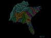
Region 2
New York: Resurrecting the Buffalo River
Over the past three decades, state and federal officials have pulled more than 200 million gallons of toxic sediment laced with lead, mercury, and PCBs from the Buffalo River. They’ve spent more than $100 million on the ongoing project so far. The restoration didn’t begin until nearly 20 years after the U.S. Department of the Interior declared the river biologically dead in the late 1960s. At the time, its waters ran thick with sewage, nitrogen, and around 100 different chemicals that factories, cities, and farmers poured directly into its flow.
The Clean Water Act made such dumping illegal, providing a kind of life support for the Buffalo until environmental groups made big moves toward cleanup. Still, progress has been slow and fragile. Turtles, bass, and perch have all returned to the waterway, but their habitat remains critically impaired: Its tainted waters still cause tumors, deformities, and reproductive problems in the region’s animals, signaling the water is not yet clean enough for beaches. And like a person who just recovered from being sick, the river’s immune system is vulnerable, so even small amounts of contaminants could topple its ecosystems.
More than one-third of the Buffalo’s 312 miles of tributaries would lose federal protection under the Trump administration’s proposed changes to the Clean Water Rule. This would make it easier for industrial-sized livestock farms and construction sites to leak hazardous chemicals and oxygen-depleting nitrates into the recuperating river, undoing more than 30 years of restoration. The river empties into Lake Erie, where manure and fertilizer runoff have sparked massive algae blooms since the early aughts.
Let the EPA know about all the work that could be undone.
New Jersey: Reckoning with legacy pollution
New Jersey is the most densely populated state in the nation, and nearly half of its residents get their water from temporary streams protected by the Clean Water Rule. Luckily, New Jersey state law is more stringent than federal regulations, even under the Clean Water Rule, so they’ll stay that way even if it’s repealed. Regardless, these waters need attention; New Jersey waterways are already highly polluted.
EPA-designated Superfund sites rank as some of the most polluted places in the country: land or water so full of hazardous waste, that they pose a serious risk to human health. New Jersey has more of them than any other state. For decades, local industry used the lower section of the Hackensack River, which extends 22 miles from Newark Bay to the Oradell Reservoir, as a dumping ground for everything from arsenic and mercury to chemicals used in pharmaceutical manufacturing. The original Clean Water Act of 1972 did curb pollution dumped directly into the river, but many of the old contaminants remain.
Those chemicals are mostly in sediment on the Hackensack’s riverbed. Because this sediment leeches chemicals into streamflow, many the river’s tributaries are now priority Superfund sites, which means the EPA will bankroll their cleanup first. One, Berry’s Creek, is considered the worst methylmercury site in the world. The stream crosses 750 acres of marshes; the EPA will have to spend $332 million before it’s healthy enough to lose its Superfund designation. Although pollution has cleared enough to allow the lower Hackensack River to once again support fish such as the Atlantic striped bass, the seafood is still too toxic to eat. In other states, where local government defaults to federal regulations, the Clean Water Rule can prevent small streams such as Berry’s Creek from ever getting so polluted in the first place.
Tell the EPA New Jersey’s cautionary tale.

Region 3
Maryland, Delaware, and Virginia: Ultimate protection for all Delmarva potholes
2015’s Clean Water Rule specifically protected more than 34,000 acres of wetland in the Chesapeake Bay watershed. Roughly the size of Washington, D.C., the pocked Delmarva pothole region comprises nearly 5,000 inland marshes on their namesake Delmarva Peninsula, which includes parts of Delaware, Maryland, and Virginia (Del-Mar-Va, get it?). The natural potholes there provide little pockets for temporary wetlands to flourish in during wet seasons. Underground flows connect the wetlands to nearby streams, but since there aren’t any aboveground connections, they’re technically considered isolated. That means the new Clean Water Act would not protect them.
Layers of soil and roots in the forested wetlands act as a filter. They keep nitrogen and phosphorus runoff from reaching the Chesapeake Bay, where elevated levels forge algae blooms and suffocate fish. Like all wetlands, the peninsula potholes provide safe haven for birds, salamanders, and frogs. (Further reading: Both WYPR FM and American University’s radio station WAMU get into the details of what makes this ecosystem extra important, and how much of it we’ve already lost.)
Some good news: Maryland, Delaware, and Virginia are all among 22 states (plus Washington, D.C.) that overturned the Trump Administration’s suspension of the Clean Water Rule last year. The reinstated Rule protects streams that don’t flow constantly as well as the Delmarva potholes, so they’re safe for now. But that might not last.
Although the wetlands connect across state lines, local law will govern their protection. Virginia is one of 13 states that prohibit state-level wetland regulation from superseding federal rules. This means that although Virginia has chosen to abide by the Clean Water Rule until the EPA makes its final decision, once revisions to the Clean Water Act are set, Virginia state law cannot protect any wetland that is not an identified WOTUS under federal law. (Further reading: The Virginia Mercury reported on the rivers––many of which feed the Chesapeake Bay––that will lose their federal guard if the definition of WOTUS is edited.)
Tell Mr. Wheeler to protect connected wetlands across state lines.
West Virginia and Pennsylvania: Backing protections along the Ohio River
More than 25 million people live in the Ohio River watershed; that’s nearly 10 percent of the nation’s population. The river courses through roughly 1,000 miles of terrain in Pennsylvania, West Virginia, Ohio, Kentucky, Indiana, and Illinois before joining the Mississippi as its largest tributary. During this journey, the Ohio sweeps up dangerous chemical byproducts from factories, wastewater from crops and mining sites, and mercury from coal plants that puff the neurotoxin into the air before it eventually settles on water and land; other times, mercury winds up in wastewater discharge. Together, these contaminants make the Ohio River the most polluted waterway in the country, but this is nothing new.
The river was so widely used for sewage discharge and coal transportation in the early 20th century that officials from eight states formed the Ohio River Valley Water Sanitation Commission (ORSANCO) more than two decades before Congress introduced the Clean Water Act. Since 1948, the commission has set pollution standards that apply to the entire length of the Ohio River, rather than allowing states to individually regulate sections. Now committee members want to determine whether or not some of their rules are duplicates of the Clean Water Act, and should therefore be cut. If ORSANCO oversight changes before federal regulations, it could punch holes in contamination control within a rivershed already rife with problems.
Nitrogen runoff from industrialized wheat, livestock, and corn operations feeds a poisonous algae called Microcystis, which has choked as much as two-thirds of the riverway in recent years. This is an example of nonpoint-source pollution, meaning it isn’t piped directly into the river, but rather trickles in sporadically. Flooded grasslands in the basin capture chemicals, bacteria, mining fluid, and fertilizer so they never reach the river, but developers can drain and build on top of some of them without a permit under the proposed rule changes. As a result, the wetlands would no longer be around to trap nonpoint-source pollutants.
The region’s fossil-fuel industry presents additional challenges. The Marcellus and Utica Shale deposits that sandwich the Ohio River from Pittsburgh to the Ohio-West Virginia border provide huge amounts of natural gas. Madeline Fleisher, a senior attorney with the Environmental Law & Policy Center in Columbus, Ohio says that while coal excavation is dwindling in the area, fracking is coming in as a replacement. This method of natural-gas extraction involves blasting water, sand, and a cocktail of chemicals into miles-long boreholes through shale rock. Fracking can contaminate drinking water in all sorts of ways, such as toxic waste slowly seeping into groundwater and dramatic chemical, oil, and natural-gas spills in river tributaries. A spill or leak in the Ohio River watershed could seriously impact drinking water for cities like Evansville, Indiana, which has just one treatment plant to process river water.
Tell the EPA how it can help.
Washington, D.C.: Keeping the Potomac on the up and up
The Potomac River has come a long way since former President Lyndon B. Johnson called it a national disgrace in 1965. The river, overrun with algae and garbage for decades, now supplies 90 percent of Washington’s drinking water. Upstream pollutants from tributaries in West Virginia, Virginia, Pennsylvania, and Maryland have subsided so much that the conservation group American Rivers just gave the Potomac its best rating since they started testing water quality in 2007. But there’s still work to do.
Underwater grasses (which provide a habitat for fish) and water quality have both been slow to recover. The river still has a huge problem with nitrates, phosphorous, and sediment runoff, which the Potomac eventually deposits into the Chesapeake Bay, the country’s largest estuary. It’s here that fresh water from more than 100,000 streams, creeks, and rivers mixes with salty tides from the Atlantic Ocean. The delicate balance of this blend is a haven for wildlife––the bay houses 2,700 species––as well as an important pillar of the economy. Commercial fishermen pull 500 million pounds of seafood from the Chesapeake Bay every year.
Keeping systems that filter out the Potomac’s biggest polluters intact is the only way to help it get truly clean again. Sixty percent of the river’s nearly 15,000-square-mile watershed is woodland, so preventing deforestation in the area is key, and the number of trees being planted along vulnerable streams has declined in recent years. Trees provide important habitat for birds, including bald eagles, and filter out the chemicals and nutrients that clog both the river and the Chesapeake Bay. Wetlands in the Potomac River watershed are especially crucial; marshes filter pollutants from runoff and capture sediment, keeping it out of flowing water. If the Trump Administration cuts protections that guard wetlands, temporary streams, and watershed woodlands against development, the Potomac, and ultimately the Chesapeake Bay, will suffer.
Tell the EPA to protect D.C.’s drinking water.
Region 4
Alabama: Aquatic biodiversity in ephemeral streams
Alabama ranks third in the nation for number of endangered species. Many of them are aquatic, which is why the state’s waterways rank number one when it comes to vulnerable species of mussels, snails, crayfish, turtles, and freshwater fish. Ephemeral streams, which don’t always flow and would, therefore, lose protection under the revised Clean Water Act, play a huge role in supporting these at-risk creatures.
Like elsewhere in Appalachia, ephemeral streams in Alabama get filled in by mountaintop mining and choked with coal ash. They’re also plagued by poultry. According to industry data self-reported to the Environmental Protection Agency in 2015, two chicken processing plants in the Black Warrior River basin released more than 1.2 million pounds of toxins––mostly nitrate––into waterways connected to the river. Excess nitrates in aquatic ecosystems create a domino effect that lowers oxygen levels so much it’s hard for fish to survive. It can also cause a disease in humans called methemoglobinemia, where blood cannot release oxygen into muscles and organs.
Meanwhile, steam power plants in Walker and Greene County, also in the Black Warrior watershed, ranked among the top 10 sources of waterborne cancer-causing toxins and those linked to developmental disorders. These chemicals aren’t good for people, and most certainly aren’t good for creatures that spend their entire lives swimming among them. The more water in a watershed, the more power it has to dilute pollutants and mitigate the risk they pose, but climate change is making Alabama hotter and drier. In 2016, more than 98 percent of Alabama suffered drought conditions, fueling a year of wildfires that torched every county in the state.
Let Andrew Wheeler know that you and the fish would like clean water.
North Carolina: Coal, PFAS, and development along Haw River tributaries
A network of 1,700 square miles of feeder streams and wetlands throughout north-central North Carolina empty into the Haw River. The watershed is developing at one of the fastest rates in the state, allowing cities like Chapel Hill, Durham, and Greensboro to sprawl. That means it’s also uniquely plagued by runoff from housing construction sites in addition to industrial pollution.
Factories in Alamance County––home to Haw River feeder streams––produce compounds called perfluoroalkyl and polyfluoroalkyl substances, or PFAS. They’re used in everything from furniture to military-grade firefighting foam and contaminate drinking water across the country. At a March hearing, Alabama Rep. Brian Fitzpatrick, co-chairman of the congressional PFAS task force, said the compound is “one of the most widespread public health crises” that the U.S. faces. It will cost $2 billion to filter PFAS from the water surrounding military sites alone. While the EPA limits more than 90 different contaminants in drinking water, including parasites like Giardia and chemicals like asbestos, chemical manufacturers are creating new PFAS compounds so quickly that the EPA can’t keep up with the research required to set advisable limits for their presence.
Troubling amounts of PFAS have made their way from feeder streams to the mainstream in North Carolina, showing up in the Haw River. The EPA has issued a health advisory for two types of PFAS compounds produced in Alamance County, limiting the amount considered safe in drinking water. But hundreds more will remain unregulated for years. Changes to the Clean Water Act would allow factories to dump waste into small waterways without the limitations and permit requirements imposed by the Clean Water Rule. Meanwhile, North Carolina’s population boom means more people could be exposed to contaminated drinking water without knowing it.
Let the EPA know about all the industrial chemicals you don’t want to drink.
South Carolina: Urban development in the Piedmont ecoregion
The ephemeral wetlands of the Piedmont ecoregion span six southern states, including northwestern South Carolina. A 2016 United States Geological Survey simulation projected urban sprawl (based on projected city expansion) in the Southeastern U.S. would fragment wetland landscapes, and that the Piedmont ecoregion would likely support the most urban expansion.
In South Carolina, the U.S. Forest Service manages huge swaths of the Piedmont, including the Sumter National Forest and Long Cane, and the Enoree Ranger Districts. However, public land within the national forest boundaries is fragmented. Because of this, most of the land in the Piedmont is privately owned. Development in the region predominantly impacts small headwater streams and wetlands that become inundated with sediment and heavy metals from urban-stormwater runoff and construction sites.
The wetlands that cover roughly one-quarter of South Carolina also take a massive hit. During heavy rains, wetlands can retain water like a sponge, allowing the deluge to slowly seep into the ground where it’s stored in an aquifer. These areas also trap impurities like nitrogen and phosphorus that cause problems downstream. When wetlands are paved, they can’t trap rain or pollution, so neighborhoods flood and chemicals wash directly into streams and rivers. Wetlands also provide a habitat for birds and other critical wildlife, and South Carolina could lose as much as 70 percent of them under the new Clean Water Act.
Ask Andrew Wheeler to minimize heavy metals and feces in your watershed.
Florida: Strict state oversight
Coastal and freshwater wetlands cover a higher percentage of Florida than any other state in the Lower 48. So it’s good to hear that Florida’s Environmental Resource Permit Program imposes state-level regulations on surface flow alteration, requiring permits for everything from stormwater drainage to installing a dock. The program also regulates isolated wetlands that aren’t hydrologically connected to other waterways, which are not regulated at the federal level—even under the 2015 Clean Water Rule. But if the EPA oversees fewer bodies of water, states will have to work harder to protect them.
Matt Cohen, a hydrologist at the University of Florida, says states that implement their own, stricter regulations could decide they’re too much trouble to enforce and default to EPA direction. This would loosen state-level draining, development, and dumping restrictions in wetlands that are not connected to navigable waterways year-round. Many of these areas are connected through underground hydrology or aboveground streams that flow only after heavy rain. That means that even though these areas could lose federal protection, they’re still capable of carrying pollutants into major waterways. When developers pave these wetlands to make way for neighborhoods, or when farmers drain them, they can no longer prevent flooding, filter pollutants like nitrogen, or support the birds and amphibians that rely on them.
Tell the EPA to keep Florida’s wetlands protected.
Georgia: Urban sprawl around Lake Lanier’s intermittent streams
Georgia has 7.7 million acres of wetlands, covering an area roughly the size of Maryland. These ecosystems stand to lose federal protection under the proposed changes to the Clean Water Act, and since most people in Georgia drink surface water, increased pollution in these waterways would directly affect humans.
The new parameters of the law put drinking water for 3.5 million people in the metro Atlanta area at risk. Lake Lanier provides potable H20 for more than one million people in the capital region. The area around the lake is developing at one of the fastest rates in the state, meaning more treated sewage, fertilizer, and heavy metals flow into the hundreds of intermittent streams that feed Lake Lanier. Intermittent streams, which usually cease their flow for part of the year, are not protected under proposed changes. The stricter Clean Water Rule does not make urban expansion impossible, but requires companies to invest in infrastructure that keep pollutants contained, treated, and out of waterways.
Kentucky: Energy industry waste and strained infrastructure
Although coal mining is on the decline in eastern Kentucky, the industry is far from gone and has left behind a legacy of corrosive waste. The Lexington Herald Leader recently published a multipart investigation into contaminated drinking water in eastern Kentucky, where mining waste pollutes both groundwater and surface water, a public health crisis that is exasperated by aging pipes. Because most town economies in eastern Kentucky relied on the coal industry, there’s little money to fix infrastructure. In the absence of coal jobs, people are moving away, leaving fewer customers to support local water companies. Those who remain often cannot afford higher water bills. Holding mining and utility companies financially responsible for contamination could help pay for cleanup and repairs.
This is playing out in federal court. The public interest law organization Earthjustice filed a lawsuit against Kentucky Utility, which owns the E.W. Brown power plant that allegedly polluted Herrington Lake––a navigable water that is protected even under the proposed changes––through groundwater. Now it’s up to the federal government to define what kinds of pollution they can legally trace back to a particular source, and whether companies that taint groundwater with a direct connection to a protected waterway should be held liable for illegally contaminating federally protected water. Loosened regulations at large would make it harder for nuanced cases like this to hold industrial polluters accountable.
Tell the EPA to protect eastern Kentucky’s drinking water.
Tennessee: 2,500 vernal pools in the Cumberland Plateau
Vernal pools are intermittent, meaning they’re only filled with water for part of the year. The depressions in what is otherwise a grassy or wooded landscape fill with rainwater in the spring, and they’re hotbeds for biodiversity. In 2015 the Clean Water Rule expanded federal protections to these unique wetland features, a direct result of a series of scientific studies that outlined their irreplaceable functions.
Vernal pools are crucial habitats for species like salamanders and tree frogs that utilize the temporary pockets of water as safe breeding grounds. Because the pools are dry part of the year, they don’t support fish or bullfrogs—natural predators that would eat larvae that begin their lifecycle in the tiny pondlike features. That’s why certain species that thrive in vernal pools cannot survive in permanent bodies of water. (Further reading: The Times Free Press has a more in-depth explanation on why the pools are crucial for critters.)
Under the proposed changes to the Clean Water Act, developers could legally clear the forests that support vernal pools on the Cumberland Plateau. Researchers have directly linked such deforestation to loss of biodiversity in the area, and parts of the wetlands themselves could fill in entirely.
Make sure the EPA knows you care about protecting America’s biodiversity.
Mississippi: Pearl River Tributaries
The Pearl River and its tributaries are already tasked with filtering Mississippi’s waste. The proposed changes to the Clean Water Act would remove regulations that monitor the amount of sewage, nitrates, and industrial chemical pollution companies can release into the small ephemeral streams (which generally only flow after heavy rainfall) that feed the larger river. It would also make it easier for untreated waste to flow downstream.
Ninety-eight industries, businesses, and municipalities already legally discharge wastewater into the Pearl River and its tributaries. Twenty sewage plants depend on the Pearl River to dilute their wastewater; a combined 92 million gallons pour into the river daily from Jackson, West Rankin, Picayune, Poplarville and Columbia alone. A proposed dam in the Rankin Hinds Pearl River Flood and Drainage Control District would restrict flow to the lower Pearl River, meaning there would be even less water to dilute downstream pollutants.
The Pearl River’s fresh water also balances the salinity of coastal marshes, including the western Mississippi Sound. According to the Army Corps of Engineers, roughly 97 percent of the commercially harvested oysters in Mississippi come from reefs in the Sound, so the industry stands to lose if water from ephemeral streams is polluted, or if construction projects sever them from flowing into the river at all.
Tell the EPA to protect Mississippi’s oyster industry and keep sewage at bay.

Region 5
Minnesota: Copper and nickel mining in Superior National Forest
Forget the license plate stat—Minnesota has almost 12,000 lakes, including Lake Superior, which has a larger surface area than any other freshwater lake in the world, and Lake Itasca, the source of the Mississippi River. Water fuels recreation, industry, and pride for Minnesotans, but 40 percent of the state’s rivers and lakes are listed as impaired, meaning they don’t meet basic quality standards for bacteria or nutrient content.
Minnesota’s wetlands are in trouble too. Just under 11 million acres of marshland remain in the state, which once supported nearly 19 million. Wetlands trap the agricultural runoff that threatens drinking water in a state where 54 percent of the terrain is farmland.
While nitrogen is less of a concern along the state’s Mesabi Iron Range, the heavily industrialized area spews methane, lead, and acid. Minnesota mines account for 75 percent of U.S. iron-ore production. Over the past 30 years, all of it has been scraped, blasted, and drilled from the Mesabi. Hardrock mining is the single largest source of toxic waste in the country. Water-rich areas like Minnesota create more opportunities for mining waste to make its way into fisheries, wetlands, and faucets. But recently, this hasn’t been reason enough to convince state officials to shift away from mineral extraction.
Superior National Forest, a cluster of boreal woodland that covers the Mesabi Iron Range, boasts nearly 2,000 lakes and 1,300 miles of major streams that support cold-water fisheries. It also houses one of the largest undeveloped copper and nickel deposits in the world, and two companies are getting closer to tapping it. Excavation would simultaneously create jobs and put both the Lake Superior watershed and Boundary Waters Canoe Area Wilderness (BWCA) at risk. Copper-nickel mining produces acidic sulfide waste when exposed to air. Acid-mining waste is so corrosive to the surrounding environment that the EPA says extraction “should be avoided.” Or it used to say that, anyway.
In 2017, the Trump Administration overturned an Obama-era moratorium that temporarily halted new mines in the area. This meant game-on for mining companies. In March, the Army Corps of Engineers greenlighted PolyMet Mining Corporation’s NorthMet project slated for an area in the St. Louis River watershed where part of the land was previously an iron-ore processing plant. Meanwhile, Twin Metals Minnesota, a subsidiary of a Chilean mining giant, wants permission to construct an underground mine on untouched land along the South Kawishiwi River, at the edge of the BWCA.
The river itself would remain protected under the new Clean Water Act, but many of the ephemeral streams and wetlands surrounding it would not, meaning a spill could easily trickle into the more than 1,000 lakes and streams of the BWCA.
More water, more reasons to file a comment.
Michigan and Wisconsin: Helping northern peatlands capture air pollution
When it comes to fighting climate change, northern peatlands punch well above their weight. Most of these bogs formed when ancient lakes filled up with dead plant matter like leaves to make nutrient-dense marshes. Submerged conditions didn’t provide enough oxygen for organic matter to decay, leaving behind pieces of dead plants mixed with infertile soil. Presto: peatland.
These bogs cover stretches of Michigan’s Upper Peninsula, Wisconsin, Alaska, and Minnesota, and are technically a type of wetland. Their peatiness gives them carbon-trapping power: A study of one Great Lakes region swath revealed that although they covered just 13 percent of the land, peatlands accounted for half of all carbon storage in the area, which also included forest. But it’s difficult to determine just how much peatland covers Earth’s surface. Thanks to satellite and thermal imagery, scientists have a better idea of how many wetlands contain peat, but not the amount each bog holds––those numbers are still largely based on estimates. That’s because the depth of organic matter varies throughout a single system, so taking measurements is extremely time-consuming.
But we do know that peatlands are great at pulling carbon from the air and storing it in the ground, where it doesn’t contribute to climate change. And while some of these ecosystems are clearly connected to bodies of water like the Great Lakes, many connections remain unclear and are hard to study. If scientists can’t find a surface connection linking a peatland to flowing water, it’s considered an isolated wetland, and therefore unprotected, under the new definition of WOTUS.
Tell the EPA to protect carbon sinks.
Ohio, Illinois, Indiana: Losing oversight in the Ohio River
More than 25 million people live in the Ohio River watershed; that’s nearly 10 percent of the nation’s population. The river courses through roughly 1,000 miles of terrain in Pennsylvania, West Virginia, Ohio, Kentucky, Indiana, and Illinois before joining the Mississippi as its largest tributary. During this journey, the Ohio sweeps up dangerous chemical byproducts from factories, wastewater from crops and mining sites, and mercury from coal plants that puff the neurotoxin into the air before it eventually settles on water and land; other times, mercury winds up in wastewater discharge. Together, these contaminants make the Ohio River the most polluted waterway in the country, but this is nothing new.
The river was so widely used for sewage discharge and coal transportation in the early 20th century that officials from eight states formed the Ohio River Valley Water Sanitation Commission (ORSANCO) more than two decades before Congress introduced the Clean Water Act. Since 1948, the commission has set pollution standards that apply to the entire length of the Ohio River, rather than allowing states to individually regulate sections. Now, committee members want to determine whether or not some of their rules are duplicates of the Clean Water Act, and should therefore be cut. If ORSANCO oversight changes before federal regulations, it could punch holes in contamination control within a rivershed already rife with problems.
Nitrogen runoff from industrialized wheat, livestock, and corn operations feeds a poisonous algae called Microcystis, which has choked as much as two-thirds of the riverway in recent years. This is an example of nonpoint source pollution, meaning it isn’t piped directly into the river, but rather trickles in sporadically. Flooded grasslands in the basin capture chemicals, bacteria, mining fluid, and fertilizer so they never reach the river, but developers can drain and build on top of some of them without a permit under the proposed rule changes. As a result, the wetlands would no longer be around to trap nonpoint source pollutants.
The region’s fossil fuel industry presents additional challenges. The Marcellus and Utica shale deposits that sandwich the Ohio River from Pittsburgh to the Ohio-West Virginia border provide huge amounts of natural gas. Madeline Fleisher, a Senior Attorney with the Environmental Law & Policy Center in Columbus, Ohio says that while coal excavation is dwindling in the area, fracking is coming in as a replacement. This method of natural gas extraction involves blasting water, sand, and a cocktail of chemicals into miles-long boreholes through shale rock. Fracking can contaminate drinking water in all sorts of ways, from toxic waste slowly seeping into groundwater to dramatic chemical, oil, and natural gas spills in river tributaries. A spill or leak in the Ohio River watershed could seriously impact drinking water for cities like Evansville, Indiana, which has just one treatment plant to process river water.
Tell the EPA how it can help.
Region 6
New Mexico: Even big tributaries are temporary
About 90 percent of New Mexico’s streams (even the big ones) are ephemeral or intermittent, meaning they don’t always flow. The Rio Puerco, Rio Galisteo, and the Rio Salado are all major tributaries of the Rio Grande, and only flow for part of the year. They’ll either lose protection under proposed Clean Water Act changes or be subject to case-by-case evaluation. And they’re already at risk: New Mexico is the only state in the nation that’s experiencing extreme drought, according to the U.S. Drought Monitor.
It’s a safe bet that deregulation will affect every waterway in New Mexico, but the Pecos River Basin is one particularly glaring example. The basin sits right where the Great Plains meet the Chihuahuan Desert near Santa Fe, and extends south into one of the most arid regions in Texas. According to Earthjustice, as many as 91 percent of streams and 62 percent of wetland in the Pecos River Basin will lack protection under the new rule. As the Southwest becomes hotter and drier, more streams in the region will only flow after heavy rain, making them ephemeral and therefore not subject to federal standards under the proposed changes. (Further reading: The New Mexico Political Reporter has documented other temporary streams in New Mexico that stand to lose protection under the new legislation.)
Almost all of New Mexico’s water could lose federal protection, tell the EPA.
Texas: Confusion in Galveston County’s Coastal Prairie Pothole Wetlands
Prairie pothole wetlands are found throughout Texas. The grassland depressions retain rainwater, which slowly seeps into the ground. The grassy wetlands serve to store surface water, recharge groundwater, and prevent flooding. When they overflow, their water pours into other wetlands, and then into a tributary that feeds Galveston Bay, a navigable waterway.
Texas prairie pothole complexes have their own provision under the 2015 Clean Water Rule, designating them as essential wetlands that deserve federal protection; the systems are connected to downstream waters through underground channels, even when they appear isolated on the surface. But representatives of the oil industry, developers, and manufacturers immediately contested that 2015 definition.
Some argue that the wetlands are, in fact, isolated, because they lack visible connections to the navigable waters protected by the EPA and U.S. Army Corps of Engineers. But prairie pothole complexes were protected under the Clean Water Rule as the result of extensive scientific research that proved the potholes have a direct connection to navigable waters. That connection will not go away under the new draft, but protection will. (Further reading: A recent article by the Houston Chronicle gets into the nitty-gritty of the region’s complicated history with the Clean Water Act.)
Tell Andrew Wheeler to keep prairie pothole wetlands clearly defined and protected by the federal government.
Oklahoma: Pollution in North Carrizo Creek Tributaries
Oklahoma’s Cimarron River’s headwaters (the smaller streams that combine to form it) are in New Mexico, one of the hardest-hit states under the proposed repeal. That means keeping its downstream tributaries clean and flowing is even more important. One of those is North Carrizo Creek, which runs near Black Mesa Preserve, a protected area for 31 rare species. Although North Carrizo Creek will remain protected, its own tributaries––many ephemeral, meaning they only flow after rainfall, and so small they don’t have names of their own––could be filled in for construction purposes, flooded with phosphorus, nitrogen, and manure from farms. Worse yet, they could get contaminated with fracking fluid from the hundreds of oil wells in the region.
Tell the EPA how they can keep the Cimarron River clean.
Arkansas: Bacteria, phosphorous, and nitrates in Buffalo National River Tributaries
The Ozark Mountains support a web of rivers, caves, and underground streams, many of which connect to the Buffalo National River. The waterway supported 1.5 million visitors in 2017 and supported more than 900 jobs. Part of it is on the EPA’s list of impaired streams due to high levels of bacteria. Big Creek, one of the river’s tributaries, made the same list.
Big Creek is fed by streams that only flow after rainfall, which stand to lose federal protection under the new Clean Water Act. This would make it easier for companies to dump untreated wastewater into pathways that lead to major rivers, even though those rivers are technically protected. Under slimmed-down federal water regulations, more than 60 percent of Arkansas’s streams and their adjacent wetlands are at risk of being filled in, paved over, and polluted. (Further reading: The Arkansas Democrat Gazette is monitoring water quality issues in this and other rivers throughout the state.)
Help the EPA support jobs in the Ozarks.
Louisiana: Making regulations in fastlands unclear
While Lousianna’s own policies closely regulate the wetlands that touch the Gulf Coast, federal law changes could drastically reduce protections for inland fastlands.
Fastlands are wetlands that were once directly connected to a stream or river but are now cut off by levees. The practice helps with flood control, or can be a means to drain wetlands to make them suitable for development and farming.
Although fastlands are technically isolated wetlands, many are still hydrologically connected to the greater system: Pumps take water from privatized fastlands and flush it back into public, and often protected, waters. The Clean Water Rule states that when a levee separates a wetland or stream from a river, the two bodies of water remain connected, so federal protections still apply. That relationship isn’t clear under the proposed changes to the Clean Water Act, so fastland protections will be open to interpretation.
Tell the EPA to make severed waterways count again.
Region 7
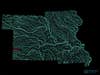
Missouri: Urbanization, hard-rock mining, and industrial agriculture in the Meramec River Watershed
The first few miles of the Meramec River only flows aboveground after heavy rainfall. It begins as an ephemeral stream in the Ozark Mountains and cuts through forests, bluffs, and glades before flowing through suburbs and mixing into the Mississippi River just south of St. Louis. The dolomite rock that makes up the Ozark region is extremely porous, which means pollutants can easily pass through the stone and into streams. Sometimes that contamination is discharge laced with bacteria from animal waste, or nitrogen from industrial agriculture fields. Other times, it’s sewage from failing septic systems and underperforming wastewater facilities, or tainted sediment from lead mines.
Small streams in the Ozark highlands prove critical to downstream health. Even when they run underground, these streams can carry bacteria and chemicals to the larger waterways they feed. The new law would remove protections for Ozark ephemeral streams that contribute to Maramec Spring. This tributary of the Meramec River, which supplies drinking water for nearly 200,000 people in the St. Louis area—it carries nearly 100 million gallons daily—runs deep below the surface. If the federal government loosens regulations for small feeder waterways like Maramec Spring, contaminated drinking water could be the cost.
Tell the EPA to keep your drinking water clean.
Iowa: Keeping Prairie Potholes intact
When glaciers scraped the continent at the end of the last ice age, they dented the Great Plains with millions of shallow divots that still pock modern-day Montana, Minnesota, Wisconsin, Iowa, and the Dakotas. Few are larger than an acre, but they hold repositories of rainwater and snowmelt that prove imperative in an otherwise grassy landscape. The natural potholes are critical breeding and nesting habitat for more than half of our nation’s migratory waterfowl, especially ducks. When they dry up, or landowners fill them in, nesting hens compete for resources. A lack of food or space means fewer ducks are born. Like other wetlands, prairie potholes also filter nitrogen runoff from the region’s corn, soy, and wheat farms, and hold water so it has time to slowly trickle into groundwater and recharge aquifers that farmers rely on for irrigation. When there aren’t wetlands to retain heavy downpours and surface runoff from paved cities, excess liquid floods crops.
The dents play a starring role in the region’s hydrology too. According to the United States Geological Survey, the loss of even a small number of prairie potholes can have huge effects. Aerial images in one study showed that watersheds with drained wetlands had almost three times more surface water than those in areas that were rarely depleted. That’s not good; excess surface water causes flooding, and its power can overwhelm stream banks and wash sediment in. When sediment builds up on a riverbed, it chokes out life that props up the base of the food chain.
The study also found that a series of small fens are more effective for water storing than single large ones that can more easily overflow. When farmers drain potholes, fewer wetlands must absorb more water. The burden makes them overflow into larger bodies that can’t absorb water as fast as their smaller counterparts. That extra water ends up in rivers and streams. When left intact, millions of potholes work together to absorb floodwaters, reducing the blow to downstream watersheds. The impact is clear in places like the Red River. Prairie pothole loss along the watershed has already caused flooding in North Dakota, Minnesota, and Iowa.
We’ve already lost at least half of the potholes we once had to crops and urban sprawl. Without the Clean Water Rule, it will be easier to degrade what we have left.
Tell the federal government to protect nutrient sinks, flood mitigators, and the Midwest duck factory.
Kansas and Nebraska: Recharging groundwater through prairie playas
More than 80 percent of streams in Kansas are ephemeral or intermittent. This means that not only do the currents stand to lose their Waters of the United States (WOTUS) protections, they also run dry for part of the year, usually evaporating while the growing season is still in full swing. When they can’t access surface water, farmers in the region tap into underground storage.
The Ogallala aquifer is crucial to American agriculture. Among the largest on the planet, the colossal reserve sits roughly 200 feet beneath the middle of the country, stretching from South Dakota down to the Texas panhandle. It feeds $35 billion worth of crops every year, including nearly half of Nebraska’s farmland. But the Ogallala recharges slowly. Virtually all water that finds its way into the subterranean storage is snowmelt or rainwater that seeped into the region’s sandy earth.
That’s where playas come in. Think of prairie playas––sometimes called playa lakes––as divots that form in high plains, typically much drier than the regions that support potholes. More than 80,000 of these shallow depressions fill with water in the spring, creating temporary wetlands responsible for as much as 95 percent of all water that refills the basin. Recharge rates in playa basins are as much as 100 times higher than areas without them, but farmers there still siphon water faster than it can be replaced. Drought accelerates depletion even more. The Kansas City Star recently chronicled stories from the farmers who will feel its absence.
Restocking the High Plains’ water supply is a huge task, but playas also play many of the same roles as prairie potholes, just in a drier climate; they’re critical for stable bird populations, and filter chemicals like nitrogen and phosphorus that are widely used in agriculture but cause problems elsewhere. There’s also sediment runoff from tilled grassland, which plugs wetlands and blocks their ability to filter and store surface water. Under the proposed changes to the Clean Water Act, only playas with a significant nexus to other water bodies would warrant federal regulation. Playas are most threatened by changes to their surrounding environment, so taking them out of consideration when planning for new land uses could help slowly eliminate the ecosystem one project at a time.
Tell the federal government to safeguard aquifers.

Region 8
North Dakota, South Dakota, and Montana: Keeping prairie potholes intact
Eighty-six percent of South Dakota’s streams are ephemeral or intermittent, as are 84 percent of North Dakota’s. Another one-third of Montana’s mountain streams fit the description. All three states are also part of the Prairie Pothole Region, a critical hydrological feature for both industry and wildlife.
When glaciers scraped over the continent at the end of the last ice age, they dented the Great Plains with millions of shallow divots that still pock modern-day Montana, Minnesota, Wisconsin, Iowa, and the Dakotas. Few are larger than an acre, but they hold repositories of rainwater and snowmelt that are imperative in an otherwise grassy landscape. The natural potholes are critical breeding and nesting habitat for more than half of our nation’s migratory waterfowl—especially ducks. When they dry up, or landowners fill them in, nesting hens compete for resources. A lack of food or space means fewer ducks are born. Like other wetlands, prairie potholes also filter nitrogen runoff from the region’s corn, soy, and wheat farms, and hold water so it has time to slowly trickle into groundwater and recharge aquifers that farmers rely on for irrigation water. When there aren’t wetlands to retain heavy downpours and surface runoff from paved cities, excess liquid floods crops.
The dents play a starring role in the region’s hydrology, too. According to the United States Geological Survey, the loss of even a small number of prairie potholes can have huge effects. Aerial images in one study showed that watersheds with drained wetlands had almost three times more surface water than those in areas that were rarely depleted. Excess surface water causes flooding, and its power can overwhelm stream banks and wash sediment in. When sediment builds up on a riverbed, it chokes out the life that is the base of the food chain. The study also found that a series of small fens are more effective water storers than a single large one. When farmers drain potholes, fewer wetlands are tasked with absorbing more water. The burden makes them overflow into larger bodies that can’t absorb water as fast as their smaller counterparts. That extra water ends up in rivers and streams. When left intact, millions of potholes work together to absorb floodwaters, reducing the blow to downstream watersheds. The impact is clear in places such as the Red River. Prairie-pothole loss along the watershed has already caused flooding in North Dakota, Minnesota, and Iowa.
We’ve already lost at least half of the potholes we once had to crops and urban sprawl. Without the Clean Water Rule, it will be easier to degrade what we have left.
Tell the federal government to protect nutrient sinks, flood mitigators, and the Midwest duck factory.
Colorado: Protecting the plains from urban sprawl
Colorado is the epicenter for some of the most important water sources in the American west. Snowmelt from the state’s massive mountain ranges serves as the headwaters for the Colorado River and the Rio Grande, the third-longest river in the continental United States. Colorado is famous for snowy peaks and deep valleys—but the Great Plains actually cover about half of the state. These eastern flatlands are home to a system of streams that feed the Purgatoire and Arkansas Rivers in the southeast, and the Platte River to the north.
Like Kansas and Nebraska, eastern Colorado also caps the Ogallala aquifer. Among the largest on the planet, this colossal water reserve makes agriculture in dry shortgrass prairies possible. It recharges slowly, and virtually all water that finds its way into the subterranean storage is snowmelt or rainwater that seeped into the region’s sandy earth. Spring snowmelt and rain fill shallow grassland depressions, called prairie playas, with water. The wetlands are responsible for 95 percent of all water that refills the basin. Recharge rates in playa basins, such as those in eastern Colorado, are as much as 100 times higher than areas without them, but farmers are still siphoning water faster than it can be replaced. Drought is accelerating depletion.
Meanwhile urban sprawl threatens to pollute ephemeral tributaries to Colorado’s eastern waterways and destroy the wetlands that recharge the Ogallala. In 2017, Colorado’s population grew at twice the national average. Sprawl eastward from Denver and Fort Collins already eats into prairie pothole and ephemeral stream territory, so with fewer federal protections in place, more developers can build homes and roads on top of streams that feed larger rivers throughout the water-stressed state.
Colorado is more than mountain streams. Tell the EPA why that’s important.
Wyoming and Utah: Loose state regulations in the Green River Basin
The Green River is the largest tributary of the Colorado. In fact, because 2018 was a low-snowpack winter, more water flowed from the Green into its well-known mainstream than from the Colorado River’s headwaters in the Rocky Mountains. Despite its significance to the western watershed, the Green River’s position––predominantly located in two states with loose protections and robust mining industries––makes it vulnerable to contamination that can kill wildlife and make people sick.
The mighty tributary winds from Wyoming’s Wind River Range down through eastern Utah—with a 40-mile pitstop near Dinosaur National Monument—where it meets the Colorado River near Canyonlands National Park. Around one-third of the Upper Green River’s tributaries are ephemeral or intermittent, fed by melting snowpack in the spring and early summer, then running dry in the fall. In Wyoming alone, the Upper Green River Basin spans seven southwestern counties: Sweetwater, Uinta, Lincoln, Sublette, Teton, Fremont, and Carbon. Small-stream pollutants in these counties eventually make their way into a critical source that supplies water to 40 million people in seven states.
Wyoming has been loosening discharge regulations since 2017, when the Trump Administration suspended the Clean Water Rule. Among them was a move that that permits five times the amount of E.coli in low-flow streams as was previously legal. These standards were based on new, lowered federal standards. WyoFile reported on another proposal that would allow fossil-fuel developers in the Moneta Divide oil and gas field to dump sodium and sulfate waste into Alkali and Badwater creeks north of Shoshoni. From there, the contaminants would travel 40 miles downstream to the Boysen Reservoir.
Meanwhile, the Deseret News reports that mining on Utah’s public lands is on the rise. More than 40 percent of Utah’s territory is designated public lands managed by the Bureau of Land Management, and recent policy changes made it easier and cheaper for companies to extract oil from these areas. The state also harbors bertrandite, the raw form of beryllium, a metal used to make cell phones, missiles, and satellites, as well as a huge shale-oil deposit.
Both Wyoming and Utah are only held to the federal government standards under the Clean Water Act. If the suspended rule is permanently reversed, contaminated water from the fossil-fuel industry, both from legal discharges into streams and accidents that dump oil or toxic byproducts into local waterways, would become an even bigger threat.
Tell the EPA to protect public lands and keep contaminants out of your water.
Region 9
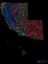
California: Preserving western vernal pools
California’s serene beachscapes and mountain-fed springs may make more appearances on desktop wallpapers, but the state owes a lot of its biological diversity—and precious groundwater—to a humbler landscape. The vernal pools that stretch from Baja California to Washington are cyclical wetlands. Shallow divots accumulate water during wet winter months and dry up in the heat of late spring. Like prairie potholes and playas, the 2015 Clean Water Rule specifically protects these temporary wetlands in California’s Central Valley, coastal terraces, and mountains. The rule cites the pools’ importance in absorbing flood waters and their consistent, if temporary, connection to the region’s waterways. Connections are most apparent when the pools overflow, but also exist through subterranean links.
The fact that vernal pools do not have year-round connections to streams and rivers is exactly what makes them biologically irreplaceable. The fleeting puddles aren’t suitable for species that prey on amphibian eggs, so they’re a safe place for other animals to breed. They also support semiaquatic plants that would otherwise be overruled. If the pools were totally full or completely dry through all four seasons, plants that favor either of those climates would take over the fauna that thrives in the cyclical ecosystem.
Large farming operations and urban sprawl have decimated nearly 90 percent of western vernal pools in the Central Valley. Even with federal protection, those that remain are threatened by extreme heat and drought brought on by climate change. The potential rule change would affect small pockets of wetlands that add up to millions of acres. Without protection, farmers can expand into these areas, and developers can extend roads or erect suburbs over them. While eliminating the Clean Water Rule could open up critical patches of habitat to destruction, some farmers fear the strict regulations interfere with their operations.
Tell the EPA to keep regulation clear.
Hawaii: Impairing island hydrology
Places like the Makua Valley on the west side of Oahu have networks of streams that appear on maps, but often turn to dry gullies. Heavy rains can fall over Hawaii even in the dry season, and around one-third of what accumulates travels off the islands through rivers. Many of them are what David Henkin, a staff attorney with Earthjustice’s Mid-Pacific office, calls flashy streams: They flow with vigor after storms, then disappear. There’s very little snowmelt to steadily supply the island’s steep watersheds, and storage in underground aquifers is limited. How water acts in Hawaii is based on these unique factors. “Streams that flow seasonally is a mainland concept,” Henkin explains. “Island hydrology is different than the mainland’s.”
The plants and creatures that live on the Hawaiian islands have evolved in sync with a landscape where streams only run for part of the year. Just like salmon in the state of Washington, the life cycle of ‘o’opu fish, which are endemic to the islands, requires both clean ocean and flowing freshwater streams. ‘O’opu spawn in rivers that wash hatchlings out to sea, where they grow for the first six months of their lives. The species returns to freshwater flows to finish maturing and eventually to lay eggs of their own. Without federal protection, the ephemeral streams that Hawaii’s wildlife rely on could be obstructed by roads, homes, or military bases like the one on Makua. This would cut fish like ‘o’opu off from their spawning grounds. KITV reports that water-diversion projects have already dried Maui’s Kahoma Stream, killing thousands of ‘o’opu.
Explain this nuanced ecosystem to Andrew Wheeler.
Arizona and Nevada: Living with water scarcity
The Silver State is the driest, and it also has the fastest-growing population in the nation. Nevadans get 70 percent of their H20 from surface water, making the population extremely susceptible to contamination—both from local sources, including stormwater runoff, and upstream tributaries that carry mining waste and agricultural chemicals and protozoa. In the south, people suck 90 percent of the water they consume from the Colorado River, a strained artery that’s currently the star of a multistate conservation plan.
Population growth, drought, and climate change are diminishing surface water in desert states. Ninety-four percent of streams in Arizona are intermittent or ephemeral. Nevada has nearly 90 percent, and they’re disappearing. Nevada Public Radio reports that longer bouts of drier, hotter weather are becoming the new normal, leading to reduced snowpack in the Rocky Mountains, the source that feeds most of Nevada’s rivers. Because these streams are evaporating for longer periods of time, it’s especially important to preserve what we have and keep sediment and chemicals from industries such as mining out of surface water.
These aboveground rivers and streams also play an important role in restocking subterranean reserves called aquifers. Around 40 percent of Arizona’s and 30 percent of Nevada’s water comes from aquifers––valuable sources that make urban life, industry, and farming possible.
According to Megan Miller, a geophysicist at Arizona State University, surface water in Arizona is often rerouted into recharge basins, essentially porous-bottomed pools of water that slowly drip into aquifers. Sandy Bahr, director of the Sierra Club’s Grand Canyon chapter, says that without the Clean Water Rule, urban developers or mining companies such as Hudbay Minerals could cover temporarily dry streambeds without a permit. The severed streams wouldn’t make it to natural recharge pools that deposit water into aquifers. Losing federal protections for ephemeral streams would disproportionately affect southwestern states such as Arizona and Nevada, where the temporary waterways are a significant portion of the states’ hydrology.
Tell the EPA not to forget the needs of our driest states.
Region 10
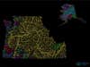
Alaska, Washington, and Oregon: Protecting salmon habitats
The snowmelt that feeds many of the nation’s rivers, especially out west, has historically recharged bodies of water gradually, rather than quickly filling them up as rainfall does. As average spring temperatures get warmer, snow is melting faster and filling rivers over a shorter period of time. That makes water levels more volatile. When levels drop earlier in the season than they used to—or spells of drought dry out streams after the snowmelt is gone—warm air can more efficiently heat them up.
Even small rises in temperature could make rivers lethal for wildlife. If development or diversion cuts off ephemeral and intermittent streams, less water will make it downstream, which will further lower levels. Under the proposed rule changes, these bodies of water won’t have protection.
Particularly hot summers in the Columbia and Snake River basins, where salmon both start and end their lives, are already heating rivers to temperatures warm enough to kill the fish before they can reproduce. As Chris Wilke, executive director of Puget Soundkeeper, explains: “As soon as water temperatures get to a point that’s comfortable for humans to swim in, that water becomes lethal for salmon.” Warmer water speeds up a fish’s metabolism, so it needs to eat more to make up for extra calories it burns. Hotter temperatures also make it harder for some of salmon’s favorite foods, like some small crustaceans and plankton, to reproduce, so there’s less grub to go around. Salmon populations in the Salish Sea off the coast of Washington have sharply declined since the 1980s.
In Alaska, industry poses the biggest threat to salmon. Wetlands cover more than one-third of the state’s territory—which accounts for more than 60 percent of all wetlands in the country. Proposed copper and gold mines in areas like Bristol Bay would dig up swaths of these flooded grasslands that flow into salmon waters. According to an EPA assessment of mining potential in the area, Bristol Bay supports the largest sockeye salmon fishery in the world; this pocket of the Bering Sea produces almost $480 million in revenue and jobs for 14,000 people. The EPA also found that the region contains relatively small traces of copper, so “mining will be economic only if conducted over large areas and will necessarily produce large amounts of waste material.” Loosened federal regulations will create fewer barriers for industries to set up shop in these hydrologically significant areas.
The Clean Water Rule protects the salmon industry. Tell the EPA all about it.
Idaho: Keeping the Little Lost off the impaired waters list
Idaho added the Little Lost River to its list of impaired waters in 1998. At the time, agriculture had diverted so much of its flow to irrigate prairie for cattle grazing that water temperatures rose and threatened the river’s fish. The Bureau of Land Management worked with conservation groups to mitigate the damage, and to prevent the river from future heating and contamination. They planted thousands of shrubs that shaded the baking water and locked down sediment that ran in from its streambanks. Their efforts helped, but the sediment remains a problem.
Under the new federal regulations, this could get worse. The Little Lost doesn’t connect above the surface with any downstream waterways. It carves through eastern Idaho’s volcanic landscape, where massive lava formations prevent it from meeting downstream waters like the Snake River at the surface. Instead, the Little Lost dips beneath the porous earth near Howe. Because of the break in overland flow, this stretch of the tributary could lose federal protection under the proposed rule change.
The river isn’t just a resource for the cattle industry. It also harbors rainbow and bull trout that cannot survive without cool water. As climate change melts snow earlier in the season, water levels in rivers like the Little Lost run lower earlier, too. If industry diverts more water—or, if sediment chokes it—temperatures in downstream flows like the Snake River will no longer be able to support cold-water species of trout and salmon.
Tell the EPA that volcanic rock lures rivers underground.