For centuries, explorers have risked their lives to reach far-flung corners of the planet. Today, satellites provide incredibly sharp images of nearly every spot on Earth, so anyone can sit back and view hard-to-reach places from the comfort of their own home.
Harvesting data from high-tech sensors on various international satellites, Germany’s space-research agency, DLR, compiled these awe-inspiring and enlightening images of islands, mountains and glaciers across the seven continents. Together they are a record of our planet in action—erupting, melting, colliding, cracking. Here, a look at some of the most impressive satellite images of the past 20 years.
This article was originally published in the inaugural issue of Science Illustrated_, a recently launched sister publication of_ Popular Science_. Like what you see? Subscribe today at_ scienceillustrated.com.
For more Science Illustrated content on PopSci.com – see the tag page here.
Lava Rises From the Deep
The Big Island of Hawaii rises 33,474 feet above the floor of the Pacific Ocean and lies over an unusually warm part of the Earth’s interior. This hot spot has produced the volcanoes that make up the Hawaiian archipelago. The three most recently active volcanoes—Kilauea, Mauna Loa and Loihi—rise out of the spot. Other, less-active and dormant volcanoes in the archipelago used to lie here as well, but the natural movement of the Pacific tectonic plate has carried them away to the northwest. This unusually detailed image was taken primarily in the infrared spectrum, allowing us to see the volcanoes’ hidden underwater bases.
A Mountain Disappears
At 16,024 feet, New Guinea’s Puncak Jaya—known by mountain climbers as the Carstensz Pyramid—is the world’s tallest mountain found on an island [its peak is in the small circle]. Intensive mining has caused great environmental damage to the unique area. The hole to the west of the peak [large circle] marks what used to be a second towering mountain but is now Grasberg, the world’s richest copper and gold mine. The removal of 125,000 tons of ore has replaced the peak with a 1,300-foot crater. The shrinking remnants of three rare equatorial glaciers in fast retreat are also visible [numbered].
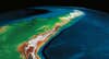
Glaciers Fill the Lakes
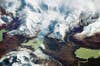
Warm weather and waning precipitation are causing the glaciers of the Patagonia region in southern Chile to retreat. At Ultima Esperanza Fjord, the “Last Hope” in Spanish, one glacier now flows into a lake, creating a stunning scene. Meltwater from the glacier’s foot runs down into a valley, forming a lake that glows emerald-green from the minerals in the rock. Humid air blowing in toward the mountains cools when it reaches a certain altitude, creating clouds over the ice.
A Landscape Changes Uphill
Africa’s tallest peak, the volcano Kilimanjaro, rises 15,100 feet from the surrounding plains, with a summit 19,340 feet above sea level. The climate changes on the way up and, along with it, the landscapes. The red areas of the image represent abundant vegetation growing near the base, while grassy moorlands are found higher up in the wine-colored region. The southern side [in the lower area of the photo] has the lushest growth; prevailing winds come from the southeast and dump life-giving precipitation on this slope before passing over the mountain. The green band near the peak is a rocky, debris-filled glacial zone topped off by a snowy summit.
Ice Hides a Mountain Range
The highest peaks of Antarctica’s Ellsworth Mountains, led by the 16,066-foot Vinson Massif [in circle], poke through a blanket of ice created by the confluence of many small glaciers that make up the famed Ronne Ice Shelf. Constant frigid temperatures prevent the ice from ever melting. Instead, the glaciers continue all the way to the sea, their white surfaces broken only where the ice has pressed down over a sharp ridge. There, the ice splits and creates crevasses averaging 150 feet deep.
Mountains Make Way for a Glacier
Only a satellite image can capture the entirety of the gigantic Malaspina glacier, which spans 1,500 square miles on the southeastern Alaskan coast. The glacier can be seen here [in circle] flowing toward the coast through a pass between mountains. It carries large amounts of rocks and gravel with it. At its edges, where the ice melts, this material is deposited, creating a landscape called a moraine [brown area]. Summer vegetation fills a swath of land between the glacier and the Gulf of Alaska. This landscape typifies the more widespread glacial action during the last ice age.
A Volcano Erupts
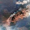
Sicily’s Mount Etna is one of the world’s most active volcanoes. Its latest eruption began in 2002 and spewed ash and lava for months. The ash formed a cloud 300 miles long that drifted east and was visible from space. Etna, which has been active for more than 2.5 million years, is a composite volcano with a tall main cone consisting of ash, pumice and hardened lava ejected by the volcano. Unlike other similar volcanoes, Etna has more than one active center and possesses several smaller cones, which have formed on lateral fissures that extend down the mountain’s sides.
Snow Tops the World
The expansive Himalayas are home to Mount Everest [in circle]—the highest peak on Earth—which rises 29,029 feet on the border between Nepal and China. In this image of Sagarmatha National Park, the seasonal monsoon clouds are absent over the mountain range. Everest is covered by a fresh coat of snow this time of year, and the area is ready for thousands of visiting hikers. Over many years, the snow on the mountainsides compresses into ice, creating large glaciers that move down through valleys. When the ice melts, rivers form that will flow for hundreds of miles before reaching the sea.
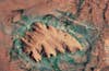
A Rock Waters the Desert
In the center of the Australian continent, Uluru, or Ayers Rock, rises 1,142 feet out of the dry plains, providing shade and water to plants and animals. The area’s sparse rainfall trickles down the rock formation and drains out slowly to form little springs where plants can grow. Small amounts of oxidized iron embedded in the sandstone give Uluru its famous shifting color as the sun passes over it. At sunset, the formation appears to glow red. In 1987, the rock along with the surrounding Uluru-Kata Tjuta National Park was designated a World Heritage Site.
![At 16,024 feet, New Guinea's Puncak Jaya—known by mountain climbers as the Carstensz Pyramid—is the world's tallest mountain found on an island [its peak is in the small circle]. Intensive mining has caused great environmental damage to the unique area. The hole to the west of the peak [large circle] marks what used to be a second towering mountain but is now Grasberg, the world's richest copper and gold mine. The removal of 125,000 tons of ore has replaced the peak with a 1,300-foot crater. The shrinking remnants of three rare equatorial glaciers in fast retreat are also visible [numbered].](https://www.popsci.com/uploads/2019/03/18/UMZWCHZA6NA4QEFJZ4E4RVYY4A.jpg?auto=webp&optimize=high&width=100)
![Africa's tallest peak, the volcano Kilimanjaro, rises 15,100 feet from the surrounding plains, with a summit 19,340 feet above sea level. The climate changes on the way up and, along with it, the landscapes. The red areas of the image represent abundant vegetation growing near the base, while grassy moorlands are found higher up in the wine-colored region. The southern side [in the lower area of the photo] has the lushest growth; prevailing winds come from the southeast and dump life-giving precipitation on this slope before passing over the mountain. The green band near the peak is a rocky, debris-filled glacial zone topped off by a snowy summit.](https://www.popsci.com/uploads/2019/03/18/YU7PEALMLCYXJJXKWPPALOI3HY.jpg?auto=webp&optimize=high&width=100)
![The highest peaks of Antarctica's Ellsworth Mountains, led by the 16,066-foot Vinson Massif [in circle], poke through a blanket of ice created by the confluence of many small glaciers that make up the famed Ronne Ice Shelf. Constant frigid temperatures prevent the ice from ever melting. Instead, the glaciers continue all the way to the sea, their white surfaces broken only where the ice has pressed down over a sharp ridge. There, the ice splits and creates crevasses averaging 150 feet deep.](https://www.popsci.com/uploads/2019/03/18/QSD5VR6ND3DJQITSDQFR75D45I.jpg?auto=webp&optimize=high&width=100)
![Only a satellite image can capture the entirety of the gigantic Malaspina glacier, which spans 1,500 square miles on the southeastern Alaskan coast. The glacier can be seen here [in circle] flowing toward the coast through a pass between mountains. It carries large amounts of rocks and gravel with it. At its edges, where the ice melts, this material is deposited, creating a landscape called a moraine [brown area]. Summer vegetation fills a swath of land between the glacier and the Gulf of Alaska. This landscape typifies the more widespread glacial action during the last ice age.](https://www.popsci.com/uploads/2019/03/18/AA7ATRKMW7CGJSGUFJRU6TAMIM.jpg?auto=webp&optimize=high&width=100)
![The expansive Himalayas are home to Mount Everest [in circle]—the highest peak on Earth—which rises 29,029 feet on the border between Nepal and China. In this image of Sagarmatha National Park, the seasonal monsoon clouds are absent over the mountain range. Everest is covered by a fresh coat of snow this time of year, and the area is ready for thousands of visiting hikers. Over many years, the snow on the mountainsides compresses into ice, creating large glaciers that move down through valleys. When the ice melts, rivers form that will flow for hundreds of miles before reaching the sea.](https://www.popsci.com/uploads/2019/03/18/J2OB73HKCAFBG4ERU37SOG5CTM.jpg?auto=webp&optimize=high&width=100)