This phantom lake in California is back with a vengeance
Tulare Lake has filled and dried up at many points in history. But this time, towns and farms stand in the way.
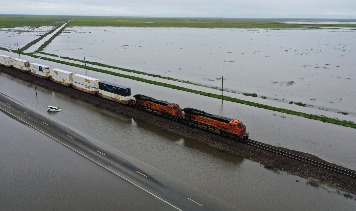
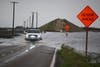
Water is quickly flooding back into California’s Tulare Lake Basin, engulfing towns and farms, submerging roads, and reviving a so-called phantom lake. Tulare was once the largest freshwater lake west of the Mississippi until settlers diverted its source rivers, forcing it to vanish by the mid-20th century. Now, it seems Tulare Lake is back with a vengeance.
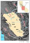
According to a 2007 study for the US Environmental Protection Agency, Tulare Lake was once a permanent feature of the San Joaquin Valley. It covered an estimated 790 square miles, creating a biodiverse wetlands ecosystem that encompassed approximately 10 percent of California. In the late 1800s, settlers began diverting Tulare’s tributaries for agricultural purposes, incrementally drying the lake and exposing nutrient-rich soil.
[Related: Rain, storms, and mudslides batter California]
Now, the lake-turned-farmland is one of the most important agricultural regions in the state, worth an estimated $2 billion dollars in dairy products and crops like grapes, cotton, corn, alfalfa, almonds, and pistachios. While an influx of water is a relief to many in California, easing a years-long drought and refilling reservoirs, it spells disaster for regions like the Tulare Basin. Residents are already seeing vast amounts of water threaten their livelihoods—and it’s only just beginning. If current conditions keep up, says UCLA climate scientist Daniel Swain,this may be the worst flood for the Lake Tulare Basin yet.

What is a phantom lake?
A phantom lake is a seasonal body of water, typically reviving during periods of intense precipitation. These lakes are usually not very deep, as far as lakes go: Prior to water diversion, Tulare was estimated to be about 37 feet deep. Shallow lakes dry up much faster than deeper ones, owing to their larger surface area to volume ratio, allowing the sun to heat up and evaporate the water quickly. The California Central Valley’s hot, arid climate makes its phantom lakes especially ephemeral.
Owens Lake, 220 miles north of Los Angeles, is another ghost that has recently resurrected. The construction of Los Angeles’ aqueduct depleted the freshwater body by diverting its tributary in 1913, but the lake is now rapidly refilling for the first time in 110 years.
Tulare Lake has a similar backstory. It comprises a natural watershed for the Sierra Nevada mountain range, which feeds meltwater through multiple rivers and into the basin. Today, levees and dams prevent water from entering the basin by diverting or blocking these rivers. Though, as evidenced by the recent storms, those systems can only do so much to prevent flooding in the face of an extreme influx of water.
Why is Tulare Lake flooding again?
Atmospheric rivers—long, narrow plumes of atmospheric moisture—are to blame for the region’s recent storms. They originate in the tropics, where warm air can take up much more water than in colder climates. Climate change is raising temperatures and the atmosphere’s capacity for holding water, amplifying storms in California and many parts of the world.
Despite the already significant flooding, most of the water that will enter the Tulare Basin hasn’t done so yet, Swain explains. Plenty of snow can still melt and flow down from the Sierra Nevada mountain range.
Flood risk will likely rise across California following an uptick in extreme precipitation events, but the Tulare Lake area is the most vulnerable. With its low elevations and proximity to the Sierra Nevadas, “[the basin] is the place where we very strongly anticipate that flood risk will increase the most in a warming climate,” Swain says.
With global heating driving up temperatures and the amount of water vapor in the atmosphere, rain has begun to replace snow at high elevations and snowmelt has accelerated earlier in the year. Swain also points out that a much more severe flood could occur in a future scenario with slightly warmer temperatures, but the same amount of precipitation. Rain and snow create the flood, but rising temperatures intensify it.
Where is all the water coming from?
The Sierra Nevada mountain range lies east of the San Joaquin Valley. Each spring, as temperatures warm, the snowpack accumulated over the winter begins to melt. As it does so, gravity pulls meltwater down from the mountains and into the lowest regions of the valley—namely, the Tulare Lake Basin./p>
This year, the Sierra Nevada snowpack is three times larger than normal and still growing. As of April 4, 2023, the estimated snowpack for the southern Sierras is 302-percent above average.
“All of that water is eventually going to have to enter the San Joaquin watershed, and a lot of it’s going to pass through the Tulare Lake Basin,” Swain says. “That’s going to present some serious challenges—I mean bigger challenges than we’re currently seeing.”
In the coming weeks, the Tulare Lake Basin and larger San Joaquin Valley will, unfortunately, experience deeper and more widespread flooding.
“There’s just that much water up in the mountains, it can’t go anywhere else, right?” Swain adds. “… In the end, the water always wins.”
How long with the Tulare Lake flood last?
Tulare Lake is an isolated, shallow body of water. It has no tributaries or outlets, so whatever water enters the basin sits there until it evaporates. An impermeable layer of clay underneath the former lake prevents most water from exiting through the ground.
[Related: What is a flash flood?]
The lake has occasionally been revived in the past. In the last big flood event in 1982 and 1983, the second wettest period in recorded history in the area, the lake did not fully disappear until 1985, per the Fresno Bee. The amount of water that has already accumulated in this year’s flood could take months or even years to evaporate—and there’s still a lot of snow waiting to melt in the wings. As of April 5, current precipitation levels in the Tulare Lake Basin rival its wettest years on record, 1968 and 1969.
What are the solutions to the flooding?
Restoring natural floodplains, adding levee setbacks and recharge basins, and “essentially giving water more room to roam in places where we’ve pre-designated it so it doesn’t cause too many problems” are among the list of solutions for the Tulare Lake region and its residents, Swain says.
But implementing land use changes is easier said than done. The San Joaquin valley has a long history of water wars, and no single entity has the authority to make these changes. Private landowners are responsible for many of these decisions, leading to extralegal activity and political conflict.
“This is a very difficult problem legally, practically, and ethically, and I don’t think there are any obvious solutions,” Swain notes. “Even though there are some obvious land use changes that would help the broader problem, getting there and implementing them in an equitable way is far from a straightforward thing to do.”
It’s already too late to do anything this spring besides survive the influx of water and try to control the damage. The challenge now lies in long-term planning for future floods. Moving forward, local conversations about these decisions should be held, including Indigenous groups like the Yokut people who were forcibly removed from the area in the 1800s.
“We’re really in a tough spot where these are big problems that have been known for a long time,” Swain says. In the coming months, he expects water will inundate some places that are now dry. Not only that, but adding water to farmland that has been treated with fertilizers, pesticides, and other chemicals may mobilize contaminants. Farms with animal agriculture produce lots of fecal waste, threatening microbial contamination. Tulare County has already issued a health warning regarding floodwater contamination.
“It’s going to be a long spring for some in the San Joaquin Valley and the Tulare Basin, in particular,” Swain says.