Your Local Weather Radar on Google Earth
Morale could use a little boost here at PopSci HQ this evening—our long awaited first office softball game has been...
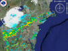
Morale could use a little boost here at PopSci HQ this evening—our long awaited first office softball game has been postponed due to the approach of inclement weather. Alas, our poor opponents will have to wait another week to face our softball wrath. One good thing has come out of Mother Nature’s cruel trick, however: the discovery of the National Weather Service’s free Doppler Radar service on Google Earth.
If you ask me, Doppler radar is one of the finer developments of our time. From switching over to the local cable channel that used to show all-radar-all-the-time as a kid to witnessing the news channels’ eternal Doppler arms race (New! Doppler Super Hawk Vision 3000!), much ballyhoo has always surrounded our ability to visualize the approach of oncoming storm clouds and prepare ourselves accordingly.
I don’t know if it will ever get better than this, though: simply head over to the NWS’s special site, choose your region and the type of radar you want (Composite Reflectivity! Storm Relative Motion!) and open the resulting file in Google Earth. Awesome. —John Mahoney
Link – NWS Enhanced Radar Images