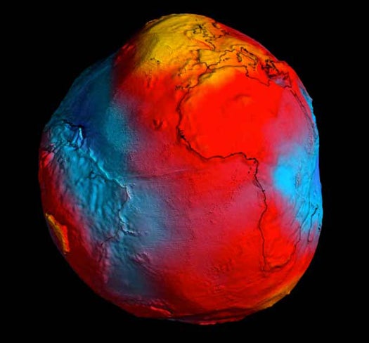
Since 2009 the European Space Agency’s Gravity field and steady-state Ocean Circulation Explorer (GOCE) has been mapping the Earth’s gravitational field, and today the agency released its most detailed model of the geoid to date. More potato-shaped than spherical, this latest model shows just how different gravity can be at different points on our planet.
The geoid is, roughly speaking, a model of the earth that doesn’t follow the surface of the crust but rather the average ocean surface if the oceans were at equilibrium and extended through the continents--in other words, the shape the earth would take based on its existing gravitational field if the tides, currents, and crust features didn’t distort things. It’s an idea that’s been around for well more than a century but only recently has been modeled precisely, largely thanks to GOCE.
Today’s new geoid marks the most precise model to date. In the above image, yellow indicates the strongest gravitational pull while blue indicates the lowest. And while we experience these differences in gravity as negligible, they have a big impact on ocean dynamics and the movement of heat around the planet--key to understanding atmospheric conditions and climate change.The geoid also informs geology, a field of study recently punctuated in no small degree by the string of earthquakes in and around Japan that have wrought serious devastation. Researchers hope that GOCE’s data--more of which will be made available this fall--will help explain and define these big movements in the Earth’s crust.
Click the BBC link below for a full 360-degree view of Earth through GOCE’s eyes.

[BBC]
Five amazing, clean technologies that will set us free, in this month's energy-focused issue. Also: how to build a better bomb detector, the robotic toys that are raising your children, a human catapult, the world's smallest arcade, and much more.


Online Content Director: Suzanne LaBarre | Email
Senior Editor: Paul Adams | Email
Associate Editor: Dan Nosowitz | Email
Assistant Editor: Colin Lecher | Email
Assistant Editor: Rose Pastore | Email
Contributing Writers:
Kelsey D. Atherton | Email
Francie Diep | Email
Shaunacy Ferro | Email
I find it amazing to see our planet as it really is.. and not as a perfectly round object. We really are living on a woobly egg.
That GOCE is pretty sexy.
It comes as no surprise
To see with your very eyes
that the Canadians to the ground closest adhere
While Chavez oil land is leaping off the sphere
Solid feet to the ground in our Midwest
rarely rufled, values up to any test
We cannot the Golden State's intensity of hue
But I will bet it's the bluest of the blue
Life style ideas floating off into space
Are we Californians part of the human race?
With a Moonbeam for a governor and a sea of red ink
It's enough to make one pick up a drink
But in this state of fruits and nuts
Of which we have an awesome glut
At least the our home looks like a product of the Emerald Isle
That and being Irish catching a wave brings out a smile.
nice poetry alaskan!
It would be great to see how the moon affects the gravity field as it orbits (I assume they eliminated the moon's effects to make this map). They could put together a really cool video clip showing the geoid bulging and shrinking with the tides.
This is not what the Earth actually looks like. This is a gravity map, it displays the strength of gravity in different regions of the globe. Contrary to popular belief gravity is not equal around the globe it differs according to mass. For example The Rockies are going to have more mass so its gravity will be slightly stronger. On the other hand the Sahara dessert will be lower in mass making gravity weeker. When you use this information to create a globe its going to display strong gravity as peaks and low gravity as valleys making the globe looks like a slightly squashed potato. The Earth of course is not completely round but its more oval due to the spinning which makes the equater slightly bulge.
Very interesting proposal Trireme. If you had a very acurate, constantly updating gravity map you would see that the gravity of the region directly below the moon would be slighlty less. This is because the gravity of the moon would tug on that region negating a very small portion of Earth's gravity. I've heard that the moon cause the Earths ground to bulge about a foot, where on the moon the ground can swell as much as 20 feet.
Fun fact: people in Southern India can jump straight into space.
One question I have about this would be how does this related to concentrations of heavy elements in the earths crust? Because wouldn't the heavier elements cause the mass in those areas to be higher then the surrounding areas?
yeah it would but it would also depend on how concentrated the heavier elements are. Most really heavy elements are sparse and compared to the lighter very rare. So elements such as gold, silver, uranium would make minor changes due to the fact that it wasn't very abundant. Also the majority of the Earths heavy elements are closer to the core. The heavier elements near the surface are only there because of volcanic eruptions and the moving of the techtonic plates.
Did anyone else notice the pattern in relation to tectonics?
cheers, eh
I know that is satellite but, men does it look like a space ship from(insert Sci-Fi franchise here)and it is awesome.
I heard that Puerto Rico is the lowest point of gravity on earth and from the map I could lite to dark blue on the Caribbean.
It is interesting that the blue and red has the rough appearance of a baseball and the yellow is the closes to the North Pole.
It is also interesting that the magnetic North Pole has been tracking into closer to Siberia by about 40 miles per a year but I wonder if the South Pole has been tracking into the Australia area the same way.
This map could be an indication to the next earth axis rotation flip.
"The geoid is, roughly speaking, a model of the earth that doesn’t follow the surface of the crust but rather the average ocean surface if the oceans were at equilibrium and extended through the continents" this definition of GEOID is wrong...its actually the definition of the SPHERIOD, while the GEOID is the surveyed shape of the earth using mean sea level IN ADDITION TO general elevation of the land extension...as you can see from the picture, the image produced was not an idealized shape, or else it would have been round and smooth, as the provided definition suggests. but it is bumpy and asymmetrical, making it the textbook definition of a GEOID.