Has the lost continent been found?

Atlantis? courtesy Google

There's no denying that Google Earth has changed the way we view our planet's landscape. With a click of your mouse, you can "fly" around your own neighborhood, zooming in from space to street level. Curious about volcanoes? Dart over to the east coast of the Big Island of Hawaii and at times you can actually see the steam where lava enters the ocean. You can even explore the whitewater rapids on the Colorado River in the Grand Canyon.

But it was Google Earth's "Ocean" layer that recently caused quite a stir among 3D geeks. The ocean-mapping capability enables users to explore undersea features like the Mid-Atlantic Ridge, an underwater mountain range in the Atlantic Ocean, and the Lo'ihi Seamount, an up-and-coming volcanic island in Hawaii.

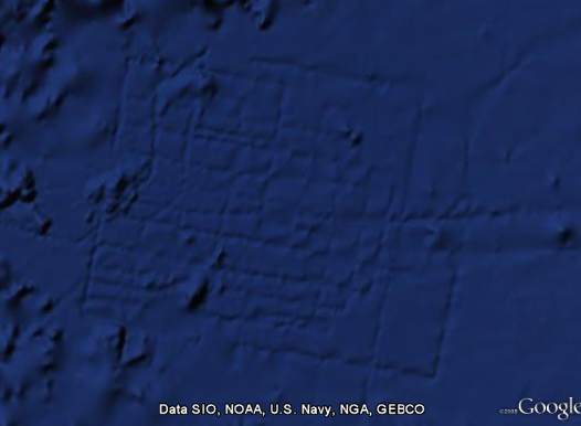
Last week, a strange-looking pattern off the west coast of Africa triggered speculations that the undersea marks might be the ruins of the lost city of Atlantis -- a legendary island that, according to the Greek philosopher Plato, sank into the Atlantic Ocean.

But two scientists -- Walter Smith of the National Oceanic and Atmospheric Administration and David Sandwell of Scripps Institution of Oceanography -- say the explanation for the patterns is a bit less exotic: the marks are actually "ship tracks" created during the process of echosounding. Sunlight, lasers, and other electromagnetic radiation can only travel less than 100 feet below the ocean's surface, but the ocean, on average, is more than two and a half miles deep. Through the process of echosounding, scientists measure the time it takes for sound to travel from a ship to the sea floor and back, which gives them an idea of how far away the seafloor is. But because the process involves mapping only a strip of the seafloor directly under the ship, the maps it generates often show the path the ship took -- hence, the "ship tracks."

If the markings were indeed the city of Atlantis, some of the city blocks would have to be over eight miles long, which is about 50 times the size of a New York City block. In reality, patterns like this can be seen over much of the ocean floor in Google Earth.

But what if we really wanted to find Atlantis? Smith and Sandwell say we probably couldn't do it with satellites, because human-made structures aren't big enough to be measured that way. But for about $2 billion, we could map the whole ocean using ships. A study by the U.S. Navy found that it would take about 200 ship-years (i.e., using one ship for 200 years) at an operational cost of about $25,000 per day. So for the price of, say, a new sports stadium, we might be able to locate Atlantis at last.

Want to learn more about breakthroughs in electronics, medicine, nanotech, and more?
Subscribe to Popular Science today, for less than $1 per issue!

19 Comments

With all due respect to Mr. Smith and Mr. Sandwell, being in the U.S. Navy I have been on a ship or two, and there is Absolutely no way that a ship can go straight enough or even make the sharp enough turns to make anything that resembles this. On top of all that if a ship were to be sailing around an area making tracks that close together it would erase the ones next to it. Idk what to tell you but it defiantly was not made by any ship.

For anyone who is interested, this feature can be found at 31 17’36.51” N 24 32’51.76” W

"In reality, patterns like this can be seen over much of the ocean floor in Google Earth. "

If anyone knows the location of others, I'd really like to see them.

I don't think that this is Atlantis but I'd like a second opinion on the "ship track" theory...

I found another "feature" with very similar properties i.e. depth/scale that cannot be "ship tracks" Check it out at 0°21'19.69"N 94°45'40.57"E

The ship tracks are artifacts in the data, not physical marks on the seafloor. Directly beneath a ship doing echosounding, the data will be quite good. Elsewhere (the 'inside' of the rectangles) may seem offset. A 'better looking' graphic representation of the data might be to trust the strips more, and fit the rest of the data to match. But one could also decry that approach as messing with the data :-).

As far as the straightness - sure, most shipping concentrates on getting from point a to point b, in between only needing to stay in the general "shipping lanes" which outside of choke points like straits can probably be broad. So ships can wander a bit with current and wind. But a research ship intent upon doing echosounding to map the seafloor can indeed hold a pretty precise path. At least these days with GPS input, one knows exactly where one's data lies on the globe.

The 0°21'19.69"N 94°45'40.57"E markings - yeah, seeing miles-high alphanumeric annotation on the seafloor off Malaysia is kind of freaky. But it's way more likely another instance of the data being wonky, not the seafloor.

jbgibson I didn't mean to imply that I thought that any of these markings were physically on the sea floor...

i dont really buy the excuse given by the scientists - if the tracks were made by the boats, then wouldn't you see them throughout the map? (you dont). also, i highly doubt the boats make perfect right angle turns while they are making thier sweeps...

1) To be a sunken island, you would still need an island. There is no percievable island ridge remander around this feature.
2) The lines are too straight. Ancient cities were not that well planned (usually they had to sprawl, burn to the ground, and then rebuild to have any sense of order, ala Nero's Rome or London in 1666).
3) The lines are too straint. A geological shift great enough to sink an island left a happy square city?
4) Square and straight does not mean "man made." Slate fields and salt crystals are just examples of straight and square things occuring in nature. (Note I am not saying that these shapes are even on the ocean floor, only that such shapes do not prove intellegent design.)

Some people (like erokv) don't want to believe Google's or scientists expalnations.... Ships were doing grids which causes small zig zags while the sonar scans the width of the lines... (the ship route is never straight but at THE EARTHS scale when they are drawn they look almost straight!!!)

The areas between the lines are blank... They need other ships to cover those areas!!!...

Remember the ships are mini scanners in a HUMONGOUS sea!!!... Ships use GPS and compass to navigate as straight as they can!...

I have not downloaded the update yet to check this stuff out.
It's in shallow waters, but has anyone looked at what data is there for known sunken cities like Port Royal? 1692 earthquake left it underwater, are there similar patterns visible?
There are also known sunken cities off Turkey and Egypt in the Med that might be worth a look as well for patterns.

Look at coordinates 0°21'19.69"N 94°45'40.57"E, you can almost see letters in the water. I read D T S I S T O. It is visible from many miles out, there is no way those are ship tracks but they arent a city either. New form of crop circles perhaps?

No, not crop circles. More like the face and supposed city in the Cydonia region of Mars. If those aren't ship tracks, then the scale alone crushes any theory that it represents a city grid.

In response to the letters: I think everyone here should take a step back and remember that Google Earth is compiled by people, and people sometimes make mistakes. I'm sure they do their best at Google to make sure that they find every impurity in their data for the program, but how many times have we gotten an accidental wrong turn on directions because a road changed? What I'm trying to say is that the letters are most likely a left over marking on a photograph or data set which was mistakenly left in. It's easy to miss if you're not at the correct viewing level. Most certainly it's not anything written in the ocean. The idea that something that collosal would be written, in english lettering no less, is perposterous.

Addressing the "ship tracks,": I agree with Free Brain. A ship's course is obviously never a straight line, but if you look at it from far enough away, all you can see is the overall route, which unless they wanted to be as ineffecient as possible, was probably as straight as they could keep it. As for the sharp turns, again, remember the scale! According to Google Earth's ruler, the corner is almost a mile long! I think given an entire mile, a small vessel could pull a turn, especially with the assistence of GPS. Besides, these ships aren't just randomly scanning the ocean and turning in whatever they find. They're usually given set coordinates to scan, and I would imagine that they would plan and carry out an efficient pattern in order to complete their job, which looks to be what we have here.

Lastly, I understand that this is a place of free discussion, and I respect that to the fullest degree, but if you're going to disagree with scientists who obviously have some merit to their words (I'm sure the good folks at Popular Science don't go to a chemist for advice on aerodynamics) you might want to do some research for yourself to see if you can back up your own words.
-Chase

I don't even see what's so surprising about cities beneath ocean waters.

Our planet has experienced much upheaval.

Too much evidence points to previous civilizations.

Probably more old pyramid bases or structures beneath the sea.

A real mystery: What were pyramids really good for? Must be something - they're way too much hard work to be just for decoration.

Another possible factor is that Google Earth is no where near "live" data, and is sometimes "edited".

Having a son in the Navy, I know for a fact that the vessel on which he serves will often be seen in port for MONTHS while they are in fact deployed to sea, and that I have never been able to find their fleet at sea when I know they were in a specific area. It is my understanding that, for security reasons, any military items are 'removed' from the maps when they are in certain areas.

So this site's apprearance might just be some editing anomaly as well.

Disclaimer: I'm a Santorini advocate for the location of Atlantis.

And I've never been in the Navy, but I once worked for a seismic data brokerage company here in Houston and what the tracks look like to me (especially considering the scale) are the result of a seismic exploration survey. The way they work is that the ships tow long lines of detecters behind the ship while noisemakers - usually either explosives or compressed air "bubblers" - which are bounced off of the sea floor to create seismic waves which are picked up by the detecters. After each run (let's say from east to west), the ship reels in the detecter array, makes a large turn, deploys the array and heads in the opposite direction. After completing the east-west runs, the ship completes the 90 degree grid by running north to south. This gives enough information to make a computerized 3D image of the subsurface geology. Then, if a certain area warrants more investigation, the ship makes a more detailed examination of the area in question.

But there are indeed anomalies off shore from the Bahamas to Japan to India to the eastern Med and the Black Sea which need more investigation. And has anyone used Google Earth to take a look at Mt Atarat?

You can find some of the most amazing places caught from google earth at
caughtfromabove.com
Hope you enjoy ;)

Sonar tracks, hmm, looking like WEATHER BALOON to me.

Some posts on here make me wanna bash my head open on a brick wall to experience life with half a brain.


June 2013: American Energy Independence

Five amazing, clean technologies that will set us free, in this month's energy-focused issue. Also: how to build a better bomb detector, the robotic toys that are raising your children, a human catapult, the world's smallest arcade, and much more.


Online Content Director: Suzanne LaBarre | Email
Senior Editor: Paul Adams | Email
Associate Editor: Dan Nosowitz | Email
Assistant Editor: Colin Lecher | Email
Assistant Editor: Rose Pastore | Email

Contributing Writers:
Rebecca Boyle | Email
Kelsey D. Atherton | Email
Francie Diep | Email
Shaunacy Ferro | Email

circ-top-header.gif
circ-cover.gif
bmxmag-ps