East Coast residents are bracing for this monster, headed their way with 125-mph winds, as a fleet of NASA satellites and airplanes monitors its evolution.
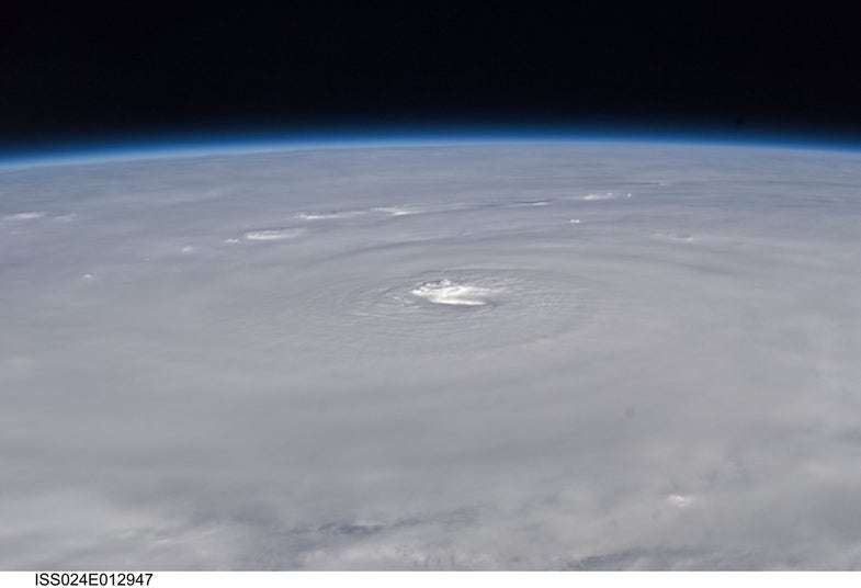
As of Wednesday morning, Hurricane Earl was a Category 3 storm, but an especially large one. Storm-force winds extend 200 miles from its eye, seen above in a photo snapped from the International Space Station.
NASA scientists are flying airplanes into this swirling mass, measuring the hurricane’s wind speeds, precipitation and more. As part of NASA's GRIP program — Genesis and Rapid Intensification Processes — a NASA DC-8 flew through Earl’s eye six times as the hurricane intensified from a Category 2 to a Category 4 storm.
Meanwhile, an ISS crew member used a digital camera with a 50mm lens to take the above photo, from a much safer distance.
138 years of Popular Science at your fingertips.
Each issue has been completely reimagined for your iPad. See our amazing new vision for magazines that goes far beyond the printed page
Stay up to date on the latest news of the future of science and technology from your iPhone or Android phone with full articles, images and offline viewing
Featuring every article from the magazine and website, plus links from around the Web. Also see our PopSci DIY feed
Science is reinventing play, from extreme sports to gamification to ridiculous roller coasters to the playgrounds of tomorrow, and this issue is chock full of fun. Also, on a less fun note: Did global warming destroy my hometown?
Earl is a category 4 as of this moment with 140 mph winds. It could stay that way all day Thursday and if it jumps 50 to 100 miles to the West then the entire coast of Eastern USA is in big trouble! Including DC, New York, Boston and more. This could be a perfect storm with it's track that it's on if the eye tracks close to the shore within 25 miles oh boy your going to have storm surges something terrible for a thousand miles of coastline. Ouch.
Storms track for storms like Earl are more difficult to predict as they hug the coast line and can be a source of significant damage to most of the Atlantic coastline as comunities/built environment face some of the strongest winds in a hurricane with attendant surge and wave action.