Anchorage suffered a 7.0 magnitude earthquake, but was spared a tsunami
No injuries have been reported.
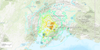
Roads broke apart, cracks radiated up buildings, and books fell from shelves today when a magnitude 7.0 earthquake rocked Anchorage, Alaska and surrounding areas.
The quake struck around 8:30 a.m. local time (12:30 p.m. on the East Coast), triggering a tsunami warning and driving some residents to evacuate inland. A number of aftershocks between magnitudes 4 and 5.8 continued to hit the Cook Inlet, just south of where the Aleutian Islands meet the mainland, before the tsunami warning was canceled. At press time, no injuries had been reported.
The ground shook for more than a minute, forcing people to take shelter under desks and doorframes as seen in this footage taken by KTVA 11 from an Anchorage courthouse.
This is what happened on the 6th floor of the Nesbett Courthouse during the Anchorage #earthquake. Both attorneys jumped under their desks. Evacuated the building after the shaking stopped. pic.twitter.com/dqHGPCv6XO
— Heather Hintze (@HeatherHintze) November 30, 2018
The shaking substantially damaged infrastructure, reducing multiple roads to fractured slabs, cutting power, and sending cracks through buildings. The Ted Stevens Anchorage International Airport has halted flights, and utilities warned residents to watch out for gas leaks and downed electrical wires.
Here’s the islanded car at the wrecked anchorage off ramp. pic.twitter.com/626As53hzF
— Nat Herz (@Nat_Herz) November 30, 2018
Anchorage’s geology may have exacerbated the effects, according to ABC News. The city sits on a sediment basin—ground closer in consistency to sand than to rock—which can slow waves down and amplify them. The extent of the event is being compared to a 1989 earthquake that struck San Francisco during the World Series.
Seismograph needles jumped as far away as Kentucky, underscoring the force of the event. On the Richter Scale, the magnitude represents how far the needle swings, but is measured logarithmically, so moving up one level brings a 10-fold increase in shaking and about a 30-fold increase in energy released. That means the original magnitude 7 shaking was 100 times more violent than any magnitude 5 aftershocks. Earthquakes also become much rarer as you move up the scale, with fewer than 20 of the size that occurred today taking place globally each year.
Alaska, which sits at the top of the geologically active Ring of Fire, feels about 40,000 annual earthquakes, and experienced the most powerful earthquake in U.S. history—a magnitude 9.2 that shook Prince William sound in 1962. That quake marked the second largest in recorded history, after a magnitude 9.5 that hit Chile two years before.
