A hotter planet might make hurricanes more destructive
Here's how.
In October 2016, Hurricane Matthew killed more than 550 people and caused $15 billion in property damages. The most powerful storm to hit the Caribbean and Southeastern United States in a decade, it whipped winds up to 160 miles per hour and pushed a 10-foot surge of seawater onto the coast. Unfortunately, Matthew might be more of a harbinger than an outlier. Based on computer models and historical records, many climatologists think that warming oceans might make storms like Matthew more common. Research suggests that a hotter planet might create the perfect weather conditions for forming these exceptionally strong, dangerous tropical cyclones. Here’s why.

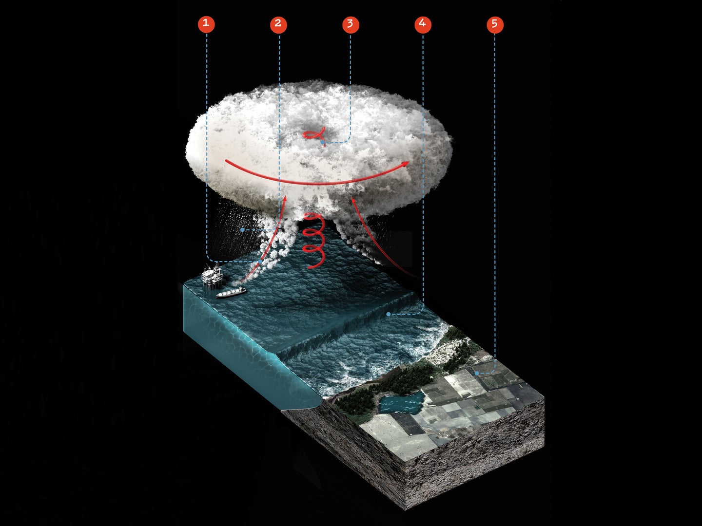
1. Pressure Cooker
A hurricane starts as a low- pressure area. It sucks in the adjacent air and gathers moisture from the balmy seawater below. In 100 years, warmer ocean surfaces will evaporate more easily, adding more hurricane fuel to the system.
2. Making It Rain
Water vapor in the low-pressure area condenses into clouds and rain. Some climate scientists predict a 20 percent increase in hurricane-related precipitation this century, which could make hurricanes even more destructive.
3. Wind Tunnel
Condensation heats the air and lowers the pressure even further. The area sucks in air harder and faster, until winds reach hurricane status at 74 mph or more. By 2100, hurricane wind speeds might increase by 2 to 11 percent.
4. Surging Forward
Strong winds sweep up a swell of water in front of a hurricane. When it hits land, this storm surge—combined with climate change- boosted sea levels—could shove floodwaters farther inland in the future, especially at high tide.
“A larger storm can push a lot more water than a small storm,” says Jim Kossin, an atmospheric scientist from the National Oceanic and Atmospheric Administration.
5. Coastal Creep
Large landmasses and cooler waters currently help buffer North Atlantic coasts from most intense hurricanes. But as sea and air temperatures rise, hurricane paths might become even less predictable and could shift northward. That could be potentially disastrous, says Kossin, because “places that are not used to being hit by tropical cycles are the least prepared for it.”
This article was originally published in the July/August 2017 Extreme Weather issue of Popular Science.